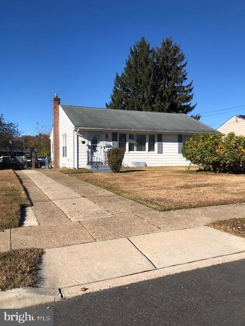


1045 Ashton Ave Beverly, NJ 08010
Estimated payment $2,021/month
Highlights
- Rambler Architecture
- No HOA
- 4-minute walk to Joseph C. Phile Field
- Wood Flooring
- Forced Air Heating and Cooling System
About This Home
Whether you're looking for your first home or downsizing, this delightful ranch style home may be just what you're looking for! No need to spend money on the natural hardwood flooring in all three bedrooms or for storage when there's a full basement (ideal for storage, romping room, or whatever kind of get-away space you envision). You'll enjoy the benefit of driving and parking in your own driveway, and surely, you'll value the fenced rear yard to make use of to your heart's content. Convenient to commuter light rail service to Trenton and Camden, where you can readily connect to AMTRAK, NJ Transit, or SEPTA. This property is being sold in its "AS IS" condition. Buyer(s) will be responsible for all inspections, certifications, and/or repairs if necessary, but don't let this deter you from being the next proud homeowner.
Listing Agent
(609) 500-4119 admin@kinniebrewassociates.com Kinniebrew Associates, Inc. Brokerage Phone: 6095004119 License #8739107 Listed on: 10/27/2025
Home Details
Home Type
- Single Family
Est. Annual Taxes
- $6,333
Year Built
- Built in 1950
Lot Details
- 6,500 Sq Ft Lot
- Lot Dimensions are 65.00 x 100.00
- Property is in average condition
Parking
- Driveway
Home Design
- Rambler Architecture
- Block Foundation
- Frame Construction
- Asphalt Roof
Interior Spaces
- 1,026 Sq Ft Home
- Property has 1 Level
- Gas Oven or Range
Flooring
- Wood
- Carpet
Bedrooms and Bathrooms
- 3 Main Level Bedrooms
- 1 Full Bathroom
Basement
- Basement Fills Entire Space Under The House
- Laundry in Basement
Schools
- Palmyra High School
Utilities
- Forced Air Heating and Cooling System
- Heating System Uses Natural Gas
- Natural Gas Water Heater
- Municipal Trash
Community Details
- No Home Owners Association
- None Ava Ilable Subdivision
Listing and Financial Details
- Tax Lot 00014
- Assessor Parcel Number 02-00205-00014
Map
Home Values in the Area
Average Home Value in this Area
Tax History
| Year | Tax Paid | Tax Assessment Tax Assessment Total Assessment is a certain percentage of the fair market value that is determined by local assessors to be the total taxable value of land and additions on the property. | Land | Improvement |
|---|---|---|---|---|
| 2025 | $6,335 | $127,900 | $58,100 | $69,800 |
| 2024 | $6,382 | $127,900 | $58,100 | $69,800 |
| 2023 | $6,382 | $127,900 | $58,100 | $69,800 |
| 2022 | $6,462 | $127,900 | $58,100 | $69,800 |
| 2021 | $5,845 | $127,900 | $58,100 | $69,800 |
| 2020 | $6,132 | $127,900 | $58,100 | $69,800 |
| 2019 | $5,973 | $127,900 | $58,100 | $69,800 |
| 2018 | $5,830 | $127,900 | $58,100 | $69,800 |
| 2017 | $5,758 | $127,900 | $58,100 | $69,800 |
| 2016 | $5,677 | $127,900 | $58,100 | $69,800 |
| 2015 | $5,614 | $127,900 | $58,100 | $69,800 |
| 2014 | $5,351 | $127,900 | $58,100 | $69,800 |
Property History
| Date | Event | Price | List to Sale | Price per Sq Ft |
|---|---|---|---|---|
| 01/13/2026 01/13/26 | Pending | -- | -- | -- |
| 10/27/2025 10/27/25 | For Sale | $289,900 | -- | $283 / Sq Ft |
Purchase History
| Date | Type | Sale Price | Title Company |
|---|---|---|---|
| Bargain Sale Deed | $102,800 | Congress Title Corp |
Mortgage History
| Date | Status | Loan Amount | Loan Type |
|---|---|---|---|
| Open | $87,380 | No Value Available |
Source: Bright MLS
MLS Number: NJBL2098526
APN: 02-00205-0000-00014
Disclaimer: Certain information contained herein is derived from information provided by parties other than Homes.com. All information provided is deemed reliable, but is not guaranteed to be accurate and should be independently verified.
![]() The data relating to real estate for sale on this website appears in part through the BRIGHT Internet Data Exchange program, a voluntary cooperative exchange of property listing data between licensed real estate brokerage firms, and is provided by BRIGHT through a licensing agreement.
The data relating to real estate for sale on this website appears in part through the BRIGHT Internet Data Exchange program, a voluntary cooperative exchange of property listing data between licensed real estate brokerage firms, and is provided by BRIGHT through a licensing agreement.
Listing information is from various brokers who participate in the Bright MLS IDX program and not all listings may be visible on the site.
The property information being provided on or through the website is for the personal, non-commercial use of consumers and such information may not be used for any purpose other than to identify prospective properties consumers may be interested in purchasing.
Some properties which appear for sale on the website may no longer be available because they are for instance, under contract, sold or are no longer being offered for sale.
Property information displayed is deemed reliable but is not guaranteed.
Copyright 2026 Bright MLS, Inc.
- 390 Wheatley Ave
- 410 Illinois Ave
- 610 Lee Ave
- 617 3rd St
- 400 Magnolia St
- 530 Magnolia St
- 301 Broad St
- 509 Laurel St
- 13 River Ln Unit V13
- 213 Laurel St
- 504 Bridge St
- 6 Fawn Ct Unit Z6
- 740 Perkins Ln
- 32 Quail Dr
- 19 Fox Ct Unit EE19
- 310 Front St
- 44 River Ln Unit HH44
- 124 Cooper St
- 212 Warren St
- 505 Jennings St

Ask me questions while you tour the home.