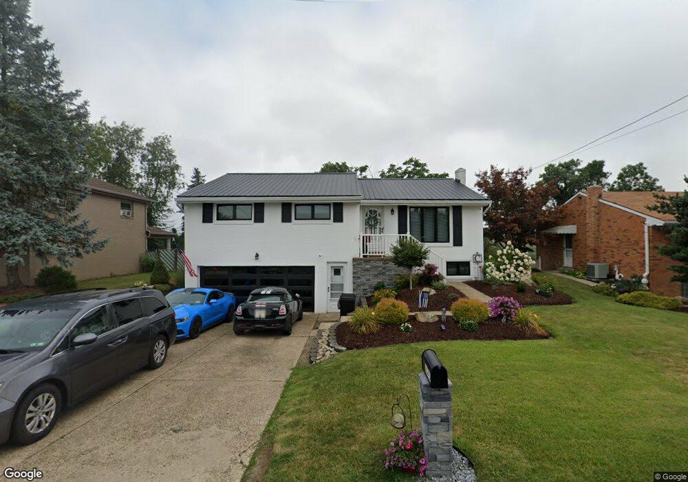
1045 Huston Dr Unit 15122 West Mifflin, PA 15122
Estimated Value: $232,841 - $254,000
3
Beds
3
Baths
1,310
Sq Ft
$186/Sq Ft
Est. Value
About This Home
This home is located at 1045 Huston Dr Unit 15122, West Mifflin, PA 15122 and is currently estimated at $243,210, approximately $185 per square foot. 1045 Huston Dr Unit 15122 is a home located in Allegheny County with nearby schools including West Mifflin Area High School, Walnut Grove Christian School, and Cornerstone Leadership Academy.
Ownership History
Date
Name
Owned For
Owner Type
Purchase Details
Closed on
Jul 29, 2019
Sold by
Goff Hal
Bought by
Campolong Richard J and Campolong Kristin A
Current Estimated Value
Home Financials for this Owner
Home Financials are based on the most recent Mortgage that was taken out on this home.
Original Mortgage
$53,000
Outstanding Balance
$46,513
Interest Rate
3.8%
Mortgage Type
New Conventional
Estimated Equity
$196,697
Purchase Details
Closed on
Jul 25, 2019
Sold by
Lewis Justin J
Bought by
Boost Capital Management Llc
Home Financials for this Owner
Home Financials are based on the most recent Mortgage that was taken out on this home.
Original Mortgage
$53,000
Outstanding Balance
$46,513
Interest Rate
3.8%
Mortgage Type
New Conventional
Estimated Equity
$196,697
Purchase Details
Closed on
Sep 10, 2004
Sold by
Ennis Rick
Bought by
Goff Hal
Create a Home Valuation Report for This Property
The Home Valuation Report is an in-depth analysis detailing your home's value as well as a comparison with similar homes in the area
Home Values in the Area
Average Home Value in this Area
Purchase History
| Date | Buyer | Sale Price | Title Company |
|---|---|---|---|
| Campolong Richard J | $153,000 | Attorney | |
| Boost Capital Management Llc | $45,000 | Attorney | |
| Goff Hal | $145,000 | -- |
Source: Public Records
Mortgage History
| Date | Status | Borrower | Loan Amount |
|---|---|---|---|
| Open | Campolong Richard J | $53,000 |
Source: Public Records
Tax History Compared to Growth
Tax History
| Year | Tax Paid | Tax Assessment Tax Assessment Total Assessment is a certain percentage of the fair market value that is determined by local assessors to be the total taxable value of land and additions on the property. | Land | Improvement |
|---|---|---|---|---|
| 2025 | $4,800 | $98,800 | $18,300 | $80,500 |
| 2024 | $4,800 | $98,800 | $18,300 | $80,500 |
| 2023 | $4,736 | $98,800 | $18,300 | $80,500 |
| 2022 | $4,597 | $98,800 | $18,300 | $80,500 |
| 2021 | $467 | $98,800 | $18,300 | $80,500 |
| 2020 | $4,509 | $98,800 | $18,300 | $80,500 |
| 2019 | $4,366 | $98,800 | $18,300 | $80,500 |
| 2018 | $467 | $98,800 | $18,300 | $80,500 |
| 2017 | $3,666 | $98,800 | $18,300 | $80,500 |
| 2016 | $467 | $98,800 | $18,300 | $80,500 |
| 2015 | $467 | $98,800 | $18,300 | $80,500 |
| 2014 | $3,634 | $98,800 | $18,300 | $80,500 |
Source: Public Records
Map
Nearby Homes
- 3326 New England Rd
- 436 Lisa Dr
- 1717 Gina Dr
- 436 Spring Valley Rd
- 444 Spring Valley Rd
- 446 Lewis Run Rd
- 0 Clairton Rd
- 609 Shadyside Dr
- 712 Shadyside Dr
- 1704 Clairton Rd
- 415 Dennison Dr
- 416 Delano Dr
- 264 Nantucket Dr
- 223 Nantucket Dr
- 198 Lynn Dr
- 300 Picture Dr
- 177 Sunrise Dr
- 280 Old Lebanon Church Rd
- 823 Blackberry St
- 148 Audrey Dr