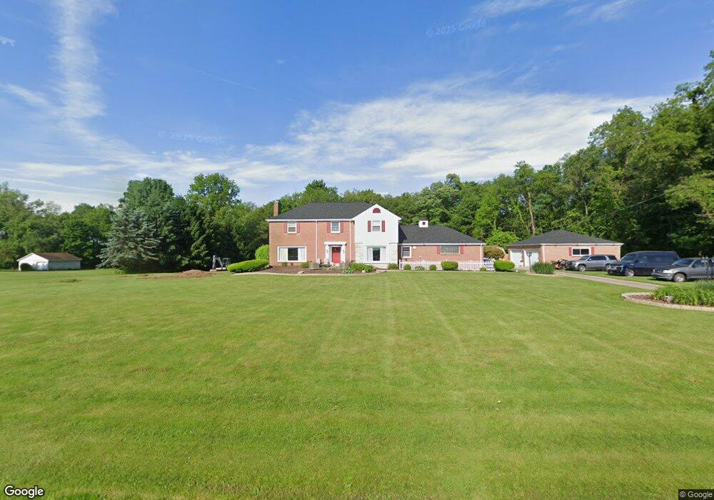
10450 New Buffalo Rd Canfield, OH 44406
Estimated Value: $436,000 - $449,000
4
Beds
3
Baths
2,682
Sq Ft
$165/Sq Ft
Est. Value
About This Home
This home is located at 10450 New Buffalo Rd, Canfield, OH 44406 and is currently estimated at $442,998, approximately $165 per square foot. 10450 New Buffalo Rd is a home located in Mahoning County with nearby schools including South Range Elementary School, South Range Middle School, and South Range High School.
Ownership History
Date
Name
Owned For
Owner Type
Purchase Details
Closed on
Oct 30, 2023
Sold by
Darkadakis William
Bought by
Darkadakis William T
Current Estimated Value
Purchase Details
Closed on
Apr 13, 2023
Sold by
Darkadakis William
Bought by
Darkadakis William T
Purchase Details
Closed on
Jul 28, 2003
Bought by
William Darkadakis
Purchase Details
Closed on
Apr 17, 1989
Bought by
Nicolaidis Argero
Create a Home Valuation Report for This Property
The Home Valuation Report is an in-depth analysis detailing your home's value as well as a comparison with similar homes in the area
Home Values in the Area
Average Home Value in this Area
Purchase History
| Date | Buyer | Sale Price | Title Company |
|---|---|---|---|
| Darkadakis William T | -- | -- | |
| Darkadakis William T | -- | -- | |
| William Darkadakis | -- | -- | |
| Nicolaidis Argero | -- | -- |
Source: Public Records
Tax History Compared to Growth
Tax History
| Year | Tax Paid | Tax Assessment Tax Assessment Total Assessment is a certain percentage of the fair market value that is determined by local assessors to be the total taxable value of land and additions on the property. | Land | Improvement |
|---|---|---|---|---|
| 2024 | $5,174 | $104,140 | $14,970 | $89,170 |
| 2023 | $4,634 | $104,140 | $14,970 | $89,170 |
| 2022 | $4,539 | $89,560 | $13,790 | $75,770 |
| 2021 | $4,595 | $89,560 | $13,790 | $75,770 |
| 2020 | $4,615 | $89,560 | $13,790 | $75,770 |
| 2019 | $4,002 | $76,930 | $13,790 | $63,140 |
| 2018 | $4,555 | $76,930 | $13,790 | $63,140 |
| 2017 | $4,421 | $76,930 | $13,790 | $63,140 |
| 2016 | $4,289 | $70,640 | $13,310 | $57,330 |
| 2015 | $4,214 | $70,640 | $13,310 | $57,330 |
| 2014 | $4,263 | $70,640 | $13,310 | $57,330 |
| 2013 | $4,230 | $70,640 | $13,310 | $57,330 |
Source: Public Records
Map
Nearby Homes
- 9974 New Buffalo Rd
- 9501 New Buffalo Rd
- 10396 Detwiler Rd
- 11158 Detwiler Rd
- 3396 W Western Reserve Rd
- 2680 W South Range Rd
- 1924 Mallard Landing
- 3079 W South Range Rd
- 1482 Lake Front Blvd
- 11695 Basinger Rd
- 1484 Lake Front Blvd
- 1486 Lake Front Blvd
- 11375 Fox Run Ln
- 699 Berklee Dr
- 11400 Sharrott Rd
- Lot 43 Berklee Dr
- Lot 44 Berklee Dr
- Lot 36 Berklee Dr
- Lot 37 Berklee Dr
- 635 Berklee Dr
- 10464 New Buffalo Rd
- 10302 New Buffalo Rd
- 10480 New Buffalo Rd
- 3014 Lynn Rd
- 2978 Lynn Rd
- 10286 New Buffalo Rd
- 10299 New Buffalo Rd
- 10268 New Buffalo Rd
- 3046 Lynn Rd
- 10277 New Buffalo Rd
- 10250 New Buffalo Rd
- 10509 New Buffalo Rd
- 10548 New Buffalo Rd
- 10247 New Buffalo Rd
- 3110 Lynn Rd
- 10230 New Buffalo Rd
- 10576 New Buffalo Rd
- 10219 New Buffalo Rd
- 10202 New Buffalo Rd
- 2751 Lynn Rd