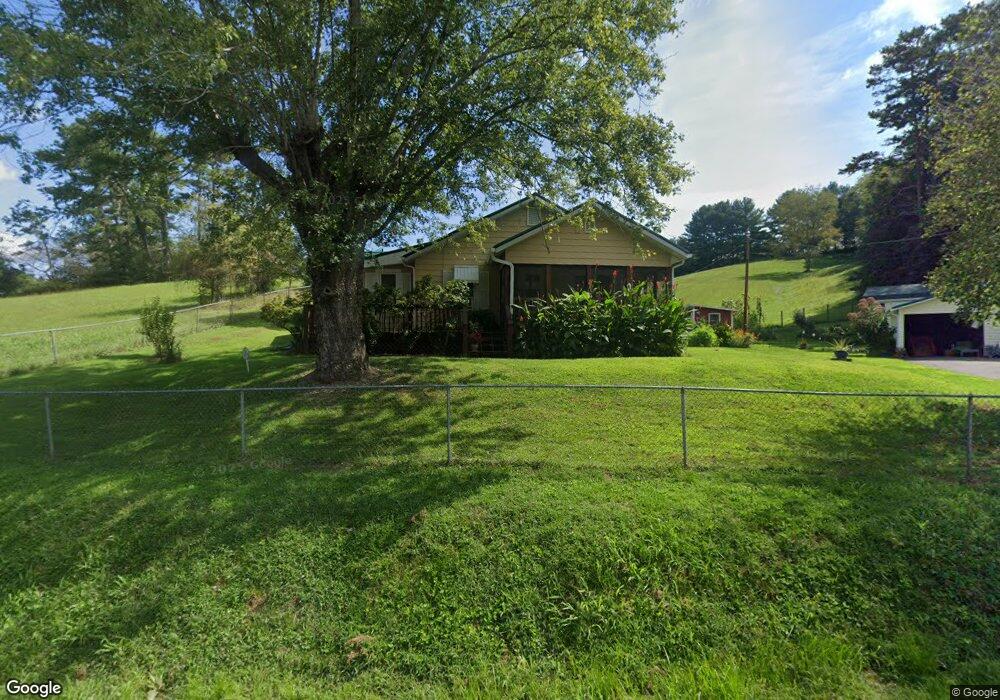
1046 Clark Branch Rd Asheville, NC 28806
West Asheville NeighborhoodEstimated Value: $371,523 - $493,000
2
Beds
2
Baths
1,130
Sq Ft
$377/Sq Ft
Est. Value
About This Home
This home is located at 1046 Clark Branch Rd, Asheville, NC 28806 and is currently estimated at $426,131, approximately $377 per square foot. 1046 Clark Branch Rd is a home located in Buncombe County with nearby schools including Clyde A. Erwin High School, West Buncombe Elementary School, and Clyde A. Erwin Middle School.
Ownership History
Date
Name
Owned For
Owner Type
Purchase Details
Closed on
Feb 12, 2010
Sold by
Hendrix Charles Rex and Hendrix Paulette
Bought by
Skenandore Roxanne Howard
Current Estimated Value
Home Financials for this Owner
Home Financials are based on the most recent Mortgage that was taken out on this home.
Original Mortgage
$186,558
Outstanding Balance
$124,270
Interest Rate
5.16%
Mortgage Type
FHA
Estimated Equity
$301,861
Create a Home Valuation Report for This Property
The Home Valuation Report is an in-depth analysis detailing your home's value as well as a comparison with similar homes in the area
Home Values in the Area
Average Home Value in this Area
Purchase History
| Date | Buyer | Sale Price | Title Company |
|---|---|---|---|
| Skenandore Roxanne Howard | $190,000 | None Available |
Source: Public Records
Mortgage History
| Date | Status | Borrower | Loan Amount |
|---|---|---|---|
| Open | Skenandore Roxanne Howard | $186,558 |
Source: Public Records
Tax History Compared to Growth
Tax History
| Year | Tax Paid | Tax Assessment Tax Assessment Total Assessment is a certain percentage of the fair market value that is determined by local assessors to be the total taxable value of land and additions on the property. | Land | Improvement |
|---|---|---|---|---|
| 2025 | $1,414 | $216,700 | $74,500 | $142,200 |
| 2024 | $1,414 | $216,700 | $89,500 | $127,200 |
| 2023 | $1,414 | $216,700 | $89,500 | $127,200 |
| 2022 | $1,350 | $216,700 | $0 | $0 |
| 2021 | $1,350 | $216,700 | $0 | $0 |
| 2020 | $1,207 | $180,400 | $0 | $0 |
| 2019 | $1,207 | $180,400 | $0 | $0 |
| 2018 | $1,189 | $180,400 | $0 | $0 |
| 2017 | $1,189 | $161,400 | $0 | $0 |
| 2016 | $1,169 | $161,400 | $0 | $0 |
| 2015 | $1,169 | $161,400 | $0 | $0 |
| 2014 | $1,136 | $161,400 | $0 | $0 |
Source: Public Records
Map
Nearby Homes
- 99999 New Leicester Hwy
- 1024 Bear Creek Rd
- 122 Ramsey Rd
- 59 Knollview Dr
- 7 Brookshire Rd
- 61 Blue Ridge Acres Rd
- 124 Shadow View Dr
- 1293 Bear Creek Rd
- 16 Sun Valley Ct
- 116 Dix Creek Chapel Rd
- 117 Old Dairy Dr
- 40 Mountain Shadows Dr
- 18 Bianca Way
- 48 Sherry Ln
- 61 Frisbee Rd
- 207 Emily Ln
- 14 H G Buckner Meadows Rd
- 99999 Lawson Ridge Rd Unit 13
- 99999 Lawson Ridge Rd Unit 11
- 14 H G Buckner Meadows
- 1029 Clark Branch Rd
- 1054 Old Leicester Hwy
- 1011 Clark Branch Rd
- 34 Heavens Above
- 34 Heavens Above None
- 1068 Clark Branch Rd
- 1000 Old Leicester Hwy
- 22 Tate Dr
- 109 Lost Ridge Rd
- 109 Lost Ridge Dr
- 35 Rose Point Dr Unit 95
- 14 Rodeo Dr
- 111 Lost Ridge Dr
- 1078 Clark Branch Rd
- 101 Lost Ridge Rd
- 5 Tate Dr
- 101 Lost Ridge Dr Unit 5
- 101 Lost Ridge Dr
- 27 Rodeo Dr