Estimated Value: $158,337 - $243,000
--
Bed
1
Bath
1,032
Sq Ft
$210/Sq Ft
Est. Value
About This Home
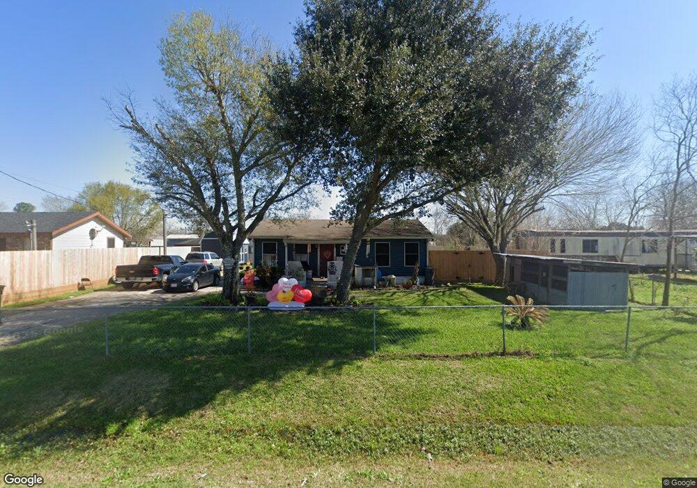
This home is located at 1046 County Road 712c, Alvin, TX 77511 and is currently estimated at $216,834, approximately $210 per square foot. 1046 County Road 712c is a home located in Brazoria County with nearby schools including Hood-Case Elementary School, G.W. Harby Junior High School, and Alvin High School.
Ownership History
Date
Name
Owned For
Owner Type
Purchase Details
Closed on
Dec 15, 2010
Sold by
American General Financial Services Inc
Bought by
Soto Sergio and Soto Sylvia
Current Estimated Value
Purchase Details
Closed on
Oct 13, 2009
Sold by
Peralta Mario and Peralta Mary
Bought by
American General Financial Services Inc
Purchase Details
Closed on
Jun 9, 2004
Sold by
Epp Inc and Eppler Roy T
Bought by
Peralta Chano and Peralta Luciana
Home Financials for this Owner
Home Financials are based on the most recent Mortgage that was taken out on this home.
Original Mortgage
$45,192
Interest Rate
6.26%
Mortgage Type
New Conventional
Purchase Details
Closed on
Apr 13, 1994
Sold by
Mynah Corp
Bought by
Eep Inc
Create a Home Valuation Report for This Property
The Home Valuation Report is an in-depth analysis detailing your home's value as well as a comparison with similar homes in the area
Home Values in the Area
Average Home Value in this Area
Purchase History
| Date | Buyer | Sale Price | Title Company |
|---|---|---|---|
| Soto Sergio | -- | Ameripoint Title | |
| Soto Sergio | -- | Ameripoint Title | |
| American General Financial Services Inc | $60,000 | None Available | |
| Peralta Chano | -- | -- | |
| Peralta Mario | -- | -- | |
| Peralta Chano | -- | -- | |
| Eep Inc | -- | -- |
Source: Public Records
Mortgage History
| Date | Status | Borrower | Loan Amount |
|---|---|---|---|
| Previous Owner | Peralta Mario | $45,192 |
Source: Public Records
Tax History Compared to Growth
Tax History
| Year | Tax Paid | Tax Assessment Tax Assessment Total Assessment is a certain percentage of the fair market value that is determined by local assessors to be the total taxable value of land and additions on the property. | Land | Improvement |
|---|---|---|---|---|
| 2025 | $449 | $83,107 | $7,700 | $76,620 |
| 2023 | $449 | $68,684 | $7,700 | $78,710 |
| 2022 | $1,330 | $62,440 | $6,160 | $56,280 |
| 2021 | $1,345 | $60,620 | $6,680 | $53,940 |
| 2020 | $1,258 | $60,620 | $6,680 | $53,940 |
| 2019 | $1,177 | $50,840 | $5,910 | $44,930 |
| 2018 | $1,180 | $50,840 | $5,910 | $44,930 |
| 2017 | $1,090 | $54,730 | $6,160 | $48,570 |
| 2016 | $991 | $54,730 | $6,160 | $48,570 |
| 2015 | $825 | $47,720 | $5,140 | $42,580 |
| 2014 | $825 | $34,870 | $5,140 | $29,730 |
Source: Public Records
Map
Nearby Homes
- 000 Herring at Cr 144 Rd
- 3629 County Road 870
- 1816 County Road 936b
- 2052 County Road 540
- 3046 County Road 529
- 1950 County Road 540
- 1871 County Road 936
- 0 County Road 540
- 432 Kendall Crest Dr
- 00 County Road 152
- 424 Kendall Crest Dr
- 415 Kendall Crest Dr
- 406 Kendall Crest Dr
- 397 Kendall Crest Dr
- 431 Kendall Crest Dr
- 418 Kendall Crest Dr
- 414 Kendall Crest Dr
- 404 Kendall Crest Dr
- 390 Kendall Crest Dr
- 396 Kendall Crest Dr
- 1050 County Road 712c
- 19 Wendi Ln
- 1051 County Road 712c
- 1025 County Road 712b
- 1064 County Road 712c
- 3277 County Road 712a
- 1075 County Road 712b
- 1076 County Road 712c
- 1093 County Road 712c
- 1093 County Road 712c
- 1048 County Road 855a
- 1052 County Road 855a
- 1044 County Road 855a
- 1040 County Road 855a
- 1018 County Road 712b
- 1032 County Road 855a
- 1089 County Road 712b
- 1036 County Road 855a
- 3274 County Road 712a
- 1028 County Road 855a