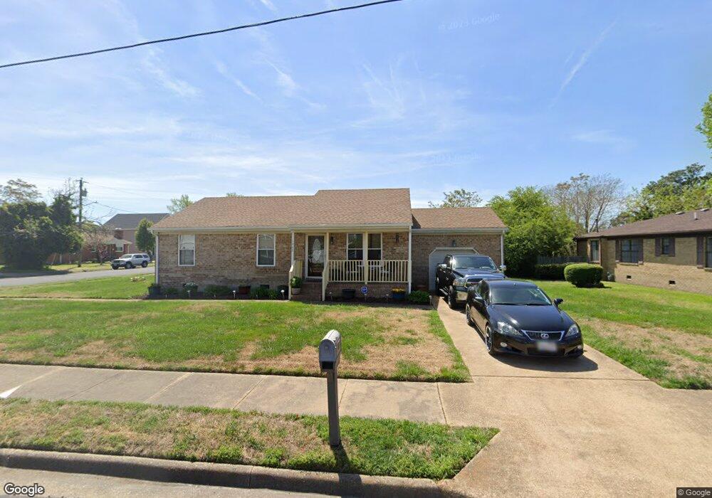
1048 Portland St Chesapeake, VA 23324
South Norfolk NeighborhoodEstimated Value: $230,000 - $273,985
3
Beds
2
Baths
1,170
Sq Ft
$218/Sq Ft
Est. Value
About This Home
This home is located at 1048 Portland St, Chesapeake, VA 23324 and is currently estimated at $254,996, approximately $217 per square foot. 1048 Portland St is a home located in Chesapeake City with nearby schools including Rena B. Wright Primary School, Truitt Intermediate School, and Oscar Smith Middle School.
Ownership History
Date
Name
Owned For
Owner Type
Purchase Details
Closed on
Dec 19, 2012
Sold by
Us Bank National Association
Bought by
Blessed Properties Inc
Current Estimated Value
Purchase Details
Closed on
Oct 27, 2004
Sold by
Brownridge Latis
Bought by
Malenda Mabiala
Home Financials for this Owner
Home Financials are based on the most recent Mortgage that was taken out on this home.
Original Mortgage
$115,000
Interest Rate
5.69%
Mortgage Type
New Conventional
Create a Home Valuation Report for This Property
The Home Valuation Report is an in-depth analysis detailing your home's value as well as a comparison with similar homes in the area
Home Values in the Area
Average Home Value in this Area
Purchase History
| Date | Buyer | Sale Price | Title Company |
|---|---|---|---|
| Blessed Properties Inc | $80,000 | -- | |
| Malenda Mabiala | $115,000 | -- |
Source: Public Records
Mortgage History
| Date | Status | Borrower | Loan Amount |
|---|---|---|---|
| Previous Owner | Malenda Mabiala | $115,000 |
Source: Public Records
Tax History Compared to Growth
Tax History
| Year | Tax Paid | Tax Assessment Tax Assessment Total Assessment is a certain percentage of the fair market value that is determined by local assessors to be the total taxable value of land and additions on the property. | Land | Improvement |
|---|---|---|---|---|
| 2025 | $2,322 | $246,300 | $85,000 | $161,300 |
| 2024 | $2,322 | $229,900 | $75,000 | $154,900 |
| 2023 | $2,014 | $219,600 | $75,000 | $144,600 |
| 2022 | $2,004 | $198,400 | $60,000 | $138,400 |
| 2021 | $1,830 | $174,300 | $55,000 | $119,300 |
| 2020 | $1,778 | $169,300 | $55,000 | $114,300 |
| 2019 | $1,778 | $169,300 | $55,000 | $114,300 |
| 2018 | $1,699 | $161,800 | $55,000 | $106,800 |
| 2017 | $1,657 | $157,800 | $55,000 | $102,800 |
| 2016 | $1,636 | $155,800 | $55,000 | $100,800 |
| 2015 | $1,636 | $155,800 | $55,000 | $100,800 |
| 2014 | $1,636 | $155,800 | $55,000 | $100,800 |
Source: Public Records
Map
Nearby Homes
- 830 Partridge Ave
- 1011 Melton St
- 1215 Hoover Ave
- 1027 Chesapeake Ave
- 1236 Old Atlantic Ave
- 2046 Christian Ave
- 2106 Liberty St
- 1138 Seaboard Ave
- 616 Leonard Ave
- 1309 Hoover Ave
- 611 Quail Ave
- 1012 Oldwood St
- 1010 Oldwood St
- 1008 Oldwood St
- 1322 Hoover Ave
- 2042 Berkley Ave
- 714 B St
- 1321 Seaboard Ave
- 1305 Chesapeake Ave
- 1616 Manson St
- 1004 Fitchett St
- 1044 Portland St
- 1008 Fitchett St
- 1040 Portland St
- 1005 Fitchett St
- 1009 Fitchett St
- 1012 Fitchett St
- 1017 Fitchett St
- 1036 Portland St
- 1016 Fitchett St
- 1021 Fitchett St
- 1004 Latham St
- 1008 Latham St
- 1014 Latham St
- 1709 Liberty St
- 1007 Nelson St
- 1705 Liberty St
- 1001 Nelson St
- 1020 Fitchett St
- 1016 Latham St