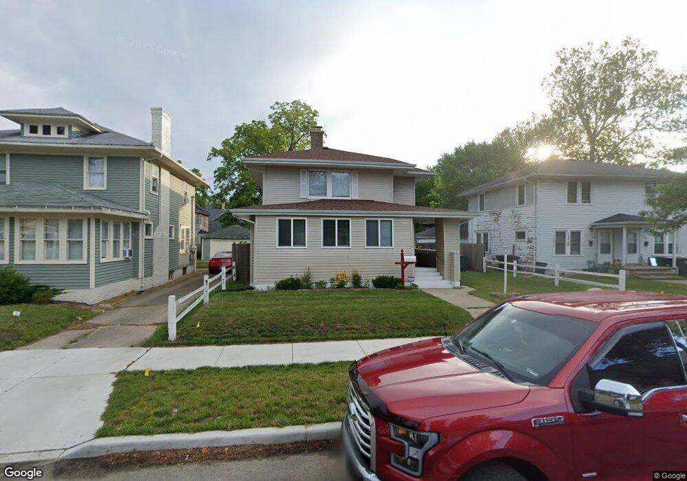
1048 Woodward Ave South Bend, IN 46616
Near Northwest NeighborhoodEstimated Value: $169,000 - $246,000
3
Beds
2
Baths
1,508
Sq Ft
$141/Sq Ft
Est. Value
About This Home
This home is located at 1048 Woodward Ave, South Bend, IN 46616 and is currently estimated at $211,940, approximately $140 per square foot. 1048 Woodward Ave is a home located in St. Joseph County with nearby schools including Muessel Primary Center, Edison Middle School, and Clay High School.
Ownership History
Date
Name
Owned For
Owner Type
Purchase Details
Closed on
Aug 8, 2006
Sold by
Mojarrad Ali
Bought by
Moore Barbara L
Current Estimated Value
Home Financials for this Owner
Home Financials are based on the most recent Mortgage that was taken out on this home.
Original Mortgage
$80,100
Outstanding Balance
$52,866
Interest Rate
8.67%
Mortgage Type
Adjustable Rate Mortgage/ARM
Estimated Equity
$159,074
Purchase Details
Closed on
Nov 4, 2005
Sold by
Hardy Stephen M and Bureau Credit
Bought by
Household Finance Corp Iii
Create a Home Valuation Report for This Property
The Home Valuation Report is an in-depth analysis detailing your home's value as well as a comparison with similar homes in the area
Home Values in the Area
Average Home Value in this Area
Purchase History
| Date | Buyer | Sale Price | Title Company |
|---|---|---|---|
| Moore Barbara L | -- | None Available | |
| Household Finance Corp Iii | -- | None Available |
Source: Public Records
Mortgage History
| Date | Status | Borrower | Loan Amount |
|---|---|---|---|
| Open | Moore Barbara L | $80,100 |
Source: Public Records
Tax History Compared to Growth
Tax History
| Year | Tax Paid | Tax Assessment Tax Assessment Total Assessment is a certain percentage of the fair market value that is determined by local assessors to be the total taxable value of land and additions on the property. | Land | Improvement |
|---|---|---|---|---|
| 2024 | $2,440 | $165,000 | $15,000 | $150,000 |
| 2023 | $2,093 | $199,100 | $18,000 | $181,100 |
| 2022 | $2,136 | $178,200 | $18,000 | $160,200 |
| 2021 | $1,936 | $162,200 | $20,400 | $141,800 |
| 2020 | $1,389 | $118,300 | $14,900 | $103,400 |
| 2019 | $1,379 | $135,600 | $32,000 | $103,600 |
| 2018 | $1,095 | $94,000 | $22,400 | $71,600 |
| 2017 | $1,117 | $93,500 | $22,400 | $71,100 |
| 2016 | $1,133 | $93,500 | $22,400 | $71,100 |
| 2014 | $1,030 | $88,500 | $22,400 | $66,100 |
Source: Public Records
Map
Nearby Homes
- 1040 Woodward Ave
- 1052 Portage Ave
- 703 Portage Ct
- 1116 Allen St
- 816 Allen St
- 1201 Allen St
- 602 W Angela Blvd
- 1245 Woodward Ave
- 803 Park Ave
- 715 Blaine Ave
- 328 Parkovash Ave
- 745 Allen St
- 920 Cleveland Ave
- 628 Portage Ave
- 310 Ostemo Place
- 716 Blaine Ave
- 617 Portage Ave
- 1253 Diamond Ave
- 1102 Diamond Ave
- 212 Marquette Ave
- 1044 Woodward Ave Unit 46
- 1052 Woodward Ave
- 1052 Woodward Ave Unit 1st Floor
- 1054 Woodward Ave
- 812 Golden Ave
- 1056 Woodward Ave
- 1071 Riverside Dr
- 808 Golden Ave
- 1069 Riverside Dr
- 1027 de Maude Ave
- 1067 Riverside Dr
- 1038 Woodward Ave
- 1025 de Maude Ave
- 1061 Riverside Dr
- 1075 Riverside Dr
- 1051 Woodward Ave
- 1053 Woodward Ave
- 1059 Riverside Dr
- 1034 Woodward Ave
- 1023 de Maude Ave