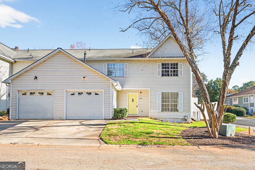
1049 Knights Bridge Ct Norcross, GA 30093
Estimated payment $1,939/month
Highlights
- Vaulted Ceiling
- Traditional Architecture
- Corner Lot
- McClure Health Science High School Rated A-
- End Unit
- Great Room
About This Home
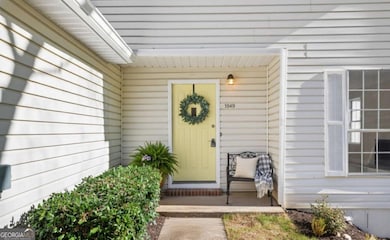
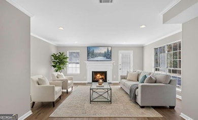
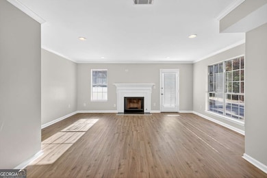
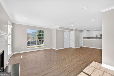
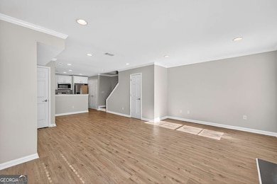
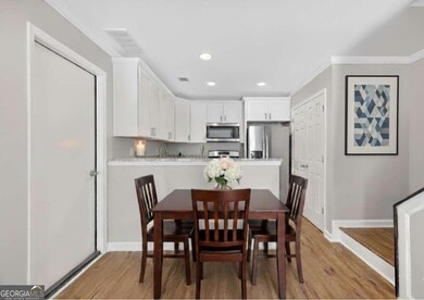
Discover this fully updated and beautifully remodeled end-unit townhome, perfectly positioned on a desirable corner lot in a prime location. Offering an attached garage and driveway, this home welcomes you with a covered entry that leads into a modern, move-in-ready interior. Enjoy new flooring throughout, an all-new kitchen featuring upgraded cabinetry, granite countertops, stainless steel appliances, and updated plumbing and fixtures. Every bathroom has been refreshed with new vanities and desirable finishes. The thoughtful layout includes two en-suite bedrooms for added privacy, ideal for roommates or a guest room. Yard maintenance is included making low-maintenance living effortless! The community also features a relaxing pool area. Situated near I-85, this townhome provides unmatched convenience with quick access to major commuter routes and a variety of shopping and dining options, including Costco, Mega Mart, parks, schools, golf courses, and year-round entertainment. A rare combination of comfort, style, and location that truly provides a standout opportunity and investment.
Open House Schedule
-
Saturday, November 15, 202511:00 am to 2:00 pm11/15/2025 11:00:00 AM +00:0011/15/2025 2:00:00 PM +00:00Add to Calendar
Townhouse Details
Home Type
- Townhome
Est. Annual Taxes
- $3,404
Year Built
- Built in 1984 | Remodeled
Lot Details
- 1,307 Sq Ft Lot
- End Unit
- 1 Common Wall
- Level Lot
HOA Fees
- $290 Monthly HOA Fees
Home Design
- Traditional Architecture
- Slab Foundation
- Composition Roof
- Vinyl Siding
Interior Spaces
- 1,272 Sq Ft Home
- 2-Story Property
- Roommate Plan
- Vaulted Ceiling
- Ceiling Fan
- Family Room with Fireplace
- Great Room
- Pull Down Stairs to Attic
- Laundry Room
Kitchen
- Oven or Range
- Microwave
- Dishwasher
- Stainless Steel Appliances
- Solid Surface Countertops
- Disposal
Flooring
- Carpet
- Tile
Bedrooms and Bathrooms
- 2 Bedrooms
- Walk-In Closet
Home Security
Parking
- 1 Car Garage
- Parking Accessed On Kitchen Level
- Garage Door Opener
Eco-Friendly Details
- Energy-Efficient Appliances
Outdoor Features
- Patio
- Porch
Schools
- Ferguson Elementary School
- Louise Radloff Middle School
- Meadowcreek High School
Utilities
- Forced Air Heating and Cooling System
- Heating System Uses Natural Gas
- Cable TV Available
Community Details
Overview
- Association fees include maintenance exterior, ground maintenance, sewer, swimming, water
- Dover Place Subdivision
Recreation
- Community Pool
Security
- Fire and Smoke Detector
Map
Home Values in the Area
Average Home Value in this Area
Tax History
| Year | Tax Paid | Tax Assessment Tax Assessment Total Assessment is a certain percentage of the fair market value that is determined by local assessors to be the total taxable value of land and additions on the property. | Land | Improvement |
|---|---|---|---|---|
| 2024 | $3,404 | $87,000 | $14,000 | $73,000 |
| 2023 | $3,404 | $77,040 | $12,000 | $65,040 |
| 2022 | $1,919 | $62,720 | $8,000 | $54,720 |
| 2021 | $1,675 | $50,080 | $8,000 | $42,080 |
| 2020 | $1,610 | $46,640 | $6,600 | $40,040 |
| 2019 | $1,450 | $41,120 | $6,600 | $34,520 |
| 2018 | $1,248 | $34,320 | $6,600 | $27,720 |
| 2016 | $852 | $22,360 | $4,800 | $17,560 |
| 2015 | $712 | $18,200 | $4,000 | $14,200 |
| 2014 | -- | $18,200 | $4,000 | $14,200 |
Property History
| Date | Event | Price | List to Sale | Price per Sq Ft |
|---|---|---|---|---|
| 11/14/2025 11/14/25 | For Sale | $259,000 | -- | $204 / Sq Ft |
Purchase History
| Date | Type | Sale Price | Title Company |
|---|---|---|---|
| Warranty Deed | $167,000 | -- | |
| Warranty Deed | -- | -- | |
| Deed | $95,000 | -- |
Mortgage History
| Date | Status | Loan Amount | Loan Type |
|---|---|---|---|
| Previous Owner | $90,000 | New Conventional |
Source: Georgia MLS
MLS Number: 10643998
APN: 6-173A-011
Disclaimer: Certain information contained herein is derived from information provided by parties other than Homes.com. All information provided is deemed reliable, but is not guaranteed to be accurate and should be independently verified.
![]() The data relating to real estate for sale on this web site comes in part from the Broker Reciprocity Program of Georgia MLS. Real estate listings held by brokerage firms other than Redfin are marked with the Broker Reciprocity logo and detailed information about them includes the name of the listing brokers. Information deemed reliable but not guaranteed. Copyright 2025 Georgia MLS. All rights reserved.
The data relating to real estate for sale on this web site comes in part from the Broker Reciprocity Program of Georgia MLS. Real estate listings held by brokerage firms other than Redfin are marked with the Broker Reciprocity logo and detailed information about them includes the name of the listing brokers. Information deemed reliable but not guaranteed. Copyright 2025 Georgia MLS. All rights reserved.
- 1037 Dover Way
- 1066 Rock Creek Ln
- 1089 Brittwood Place
- 1098 Mansfield Ct
- 1097 Rock Creek Ln
- 1090 Brittwood Place
- 5016 Comanche Ct NW
- 5148 Whited Way NW Unit 1
- 1411 Indian Way NW
- 1033 Park Forest Ct NW
- 1020 Park Forest Dr NW
- 5181 Cold Springs Dr NW
- 862 Brandlwood Way NW Unit 2
- 1360 Dickens Rd NW
- 4608 Rosemear Ct Unit 9
- 849 Cadet Ct NW
- 1066 Worcester Place NW Unit 4
- 1336 Sugarwood Ln
- 1043 Rock Creek Ln
- 4897 Warners Trail
- 1077 Mansfield Ct
- 1066 Rock Creek Ln
- 1100 Indian Trail Lilburn Rd
- 1058 Mansfield Ct
- 1121 Indian Trial Rd
- 4966 Cold Springs Dr NW
- 1006 Park Forest Trail NW
- 868 Wilton Ln NW
- 5176 Paisley Ct NW
- 799 Jodeco Cir NW
- 1088 Riva Ridge Dr NW
- 1086 Riva Ridge Dr
- 806 Houndstooth Trail NW
- 1335 Indian Trail Liburn Rd NW
- 796 Indian Lake Dr NW
- 50 Stoneview Trail NW
- 760 Indian Lake Dr NW
- 6126 Rockbridge School Rd
