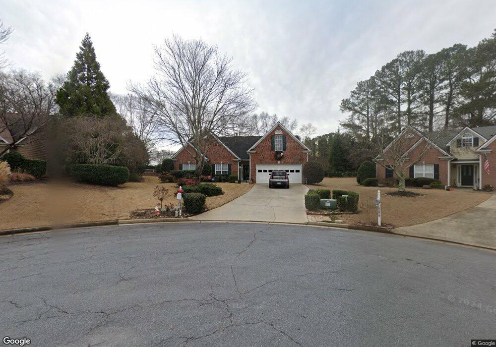
1049 Rolling Rock Ct Sugar Hill, GA 30518
Estimated Value: $433,205 - $486,000
3
Beds
2
Baths
2,443
Sq Ft
$186/Sq Ft
Est. Value
About This Home
This home is located at 1049 Rolling Rock Ct, Sugar Hill, GA 30518 and is currently estimated at $455,051, approximately $186 per square foot. 1049 Rolling Rock Ct is a home located in Gwinnett County with nearby schools including Sugar Hill Elementary School, Lanier Middle School, and Lanier High School.
Ownership History
Date
Name
Owned For
Owner Type
Purchase Details
Closed on
May 6, 2003
Sold by
Windcrest Homes Inc
Bought by
Canty Donna
Current Estimated Value
Home Financials for this Owner
Home Financials are based on the most recent Mortgage that was taken out on this home.
Original Mortgage
$144,400
Outstanding Balance
$61,987
Interest Rate
5.86%
Mortgage Type
New Conventional
Estimated Equity
$393,064
Create a Home Valuation Report for This Property
The Home Valuation Report is an in-depth analysis detailing your home's value as well as a comparison with similar homes in the area
Home Values in the Area
Average Home Value in this Area
Purchase History
| Date | Buyer | Sale Price | Title Company |
|---|---|---|---|
| Canty Donna | $185,400 | -- |
Source: Public Records
Mortgage History
| Date | Status | Borrower | Loan Amount |
|---|---|---|---|
| Open | Canty Donna | $144,400 |
Source: Public Records
Tax History Compared to Growth
Tax History
| Year | Tax Paid | Tax Assessment Tax Assessment Total Assessment is a certain percentage of the fair market value that is determined by local assessors to be the total taxable value of land and additions on the property. | Land | Improvement |
|---|---|---|---|---|
| 2025 | $656 | $182,120 | $40,000 | $142,120 |
| 2024 | $4,172 | $162,360 | $28,000 | $134,360 |
| 2023 | $4,172 | $162,360 | $28,000 | $134,360 |
| 2022 | $4,017 | $154,120 | $19,760 | $134,360 |
| 2021 | $3,260 | $113,680 | $19,760 | $93,920 |
| 2020 | $3,759 | $113,680 | $19,760 | $93,920 |
| 2019 | $2,890 | $100,840 | $19,760 | $81,080 |
| 2018 | $3,359 | $100,840 | $19,760 | $81,080 |
| 2016 | $2,890 | $82,400 | $13,200 | $69,200 |
| 2015 | $2,915 | $82,400 | $13,200 | $69,200 |
| 2014 | -- | $70,760 | $13,200 | $57,560 |
Source: Public Records
Map
Nearby Homes
- 4950 Rolling Rock Dr
- 815 Woods Chapel Rd
- 0 (4989 ?) Hidden Branch Dr
- 5028 Hidden Branch Dr
- 5008/4998 Hidden Branch Dr
- 5008 Hidden Branch Dr
- 5152 Park Vale Dr
- 5059 Hidden Branch Dr
- 5000 Sugar Creek Dr
- 4687 Riley Run Ct Unit 1
- 1091 Level Creek Rd
- 4679 Gold Dust Trail Unit 1
- 384 Sunset Hollow St Unit 2
- 384 Sunset Hollow St
- 5166 Thorin Oak Cir Unit 7
- 5229 Pine Branch Ct
- 5109 Dogwood Hills Dr
- Schubert Plan at Park Ridge at Sugar Hill
- Mendelssohn Plan at Park Ridge at Sugar Hill
- 4812 Moonview Ln Unit 4
- 1039 Rolling Rock Ct
- 1059 Rolling Rock Ct
- 1038 Rolling Rock Ct
- 0 Rolling Rock Ct Unit 8366250
- 0 Rolling Rock Ct Unit 3204251
- 0 Rolling Rock Ct Unit 7083596
- 0 Rolling Rock Ct Unit 9051765
- 0 Rolling Rock Ct Unit 7301300
- 0 Rolling Rock Ct Unit 7437835
- 4915 Rolling Rock Dr
- 1048 Rolling Rock Ct Unit N/a
- 1048 Rolling Rock Ct
- 916 Level Creek Rd
- 4900 Rolling Rock Dr
- 5080 Rolling Rock Dr
- 4925 Rolling Rock Dr
- 4910 Rolling Rock Dr
- 5070 Rolling Rock Dr
- 4920 Rolling Rock Dr
- 906 Level Creek Rd