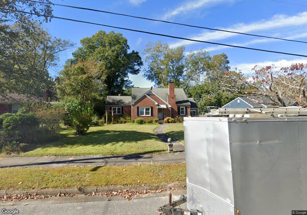
105 Barnard Dr Wilmington, NC 28405
Carolina Heights NeighborhoodEstimated Value: $338,000 - $460,000
3
Beds
2
Baths
1,656
Sq Ft
$243/Sq Ft
Est. Value
About This Home
This home is located at 105 Barnard Dr, Wilmington, NC 28405 and is currently estimated at $403,235, approximately $243 per square foot. 105 Barnard Dr is a home located in New Hanover County with nearby schools including Rachel Freeman School of Engineering, Williston Middle School, and New Hanover High School.
Ownership History
Date
Name
Owned For
Owner Type
Purchase Details
Closed on
Jun 19, 2025
Sold by
Maggard Carla M
Bought by
Wise Johnathon and Wise Allison
Current Estimated Value
Purchase Details
Closed on
Apr 30, 2018
Sold by
Robertson Heather L
Bought by
Maggard Carla M
Purchase Details
Closed on
Jul 26, 2012
Sold by
Mcfadyen Betty A
Bought by
Mcfadyen Betty A Life Estate
Purchase Details
Closed on
May 7, 2002
Sold by
Mcfadyen Johnnie C
Bought by
Mcfadyen Betty A
Purchase Details
Closed on
Aug 11, 1970
Sold by
Moore James E Ann Slocum
Bought by
Mcfadyen Johnnie C Betty A
Create a Home Valuation Report for This Property
The Home Valuation Report is an in-depth analysis detailing your home's value as well as a comparison with similar homes in the area
Home Values in the Area
Average Home Value in this Area
Purchase History
| Date | Buyer | Sale Price | Title Company |
|---|---|---|---|
| Wise Johnathon | $341,000 | None Listed On Document | |
| Maggard Carla M | -- | None Available | |
| Mcfadyen Betty A Life Estate | -- | -- | |
| Mcfadyen Betty A | -- | -- | |
| Mcfadyen Johnnie C Betty A | $17,000 | -- |
Source: Public Records
Tax History Compared to Growth
Tax History
| Year | Tax Paid | Tax Assessment Tax Assessment Total Assessment is a certain percentage of the fair market value that is determined by local assessors to be the total taxable value of land and additions on the property. | Land | Improvement |
|---|---|---|---|---|
| 2025 | $3,073 | $522,100 | $120,400 | $401,700 |
| 2024 | $1,995 | $229,300 | $66,800 | $162,500 |
| 2023 | $1,995 | $229,300 | $66,800 | $162,500 |
| 2022 | $1,949 | $229,300 | $66,800 | $162,500 |
| 2021 | $1,962 | $229,300 | $66,800 | $162,500 |
| 2020 | $1,948 | $184,900 | $42,300 | $142,600 |
| 2019 | $1,948 | $184,900 | $42,300 | $142,600 |
| 2018 | $1,948 | $184,900 | $42,300 | $142,600 |
| 2017 | $1,948 | $184,900 | $42,300 | $142,600 |
| 2016 | $1,716 | $154,900 | $36,000 | $118,900 |
| 2015 | $1,640 | $154,900 | $36,000 | $118,900 |
| 2014 | $1,571 | $154,900 | $36,000 | $118,900 |
Source: Public Records
Map
Nearby Homes
- 102 N 25th St
- 221 N 26th St
- 106 Kenwood Ave
- 2612 Princess Place Dr
- 110 Kenwood Ave
- 2906 Market St Unit 202
- 6 Keaton Ave
- 115 Forest Hills Dr
- 2401 Westminister Way
- 2208 Carlton Ave
- 17 Montgomery Ave
- 2024 Market St
- 418 Forest Hills Dr
- 222 Evans St
- 2020 Princess Place Dr
- 2117 Plaza Dr
- 421 Evans St
- 2119 Metts Ave
- 115 Covil Ave Unit 102
- 123 Covil Ave Unit 203