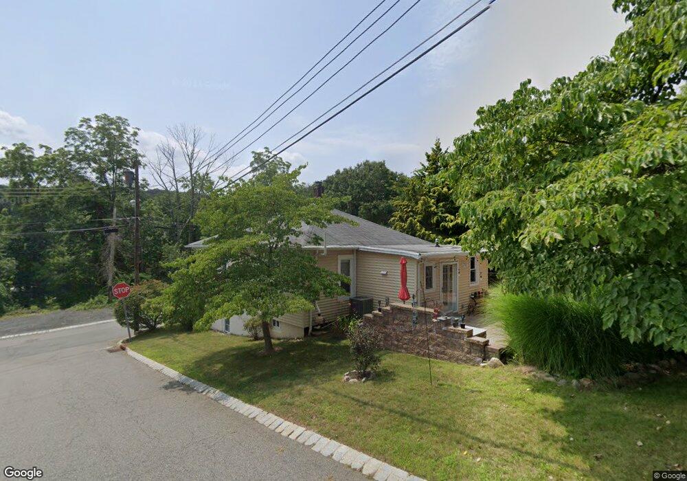
105 Birch St Wharton, NJ 07885
Estimated Value: $371,000 - $472,000
--
Bed
--
Bath
898
Sq Ft
$455/Sq Ft
Est. Value
About This Home
This home is located at 105 Birch St, Wharton, NJ 07885 and is currently estimated at $408,544, approximately $454 per square foot. 105 Birch St is a home located in Morris County with nearby schools including Marie V. Duffy Elementary School and A C Mac Kinnon Middle School.
Ownership History
Date
Name
Owned For
Owner Type
Purchase Details
Closed on
Jun 27, 2007
Sold by
Segura Francisco and Penaga Christopher J
Bought by
Anturi Freddy and Marin Mary Y
Current Estimated Value
Home Financials for this Owner
Home Financials are based on the most recent Mortgage that was taken out on this home.
Original Mortgage
$204,000
Interest Rate
6.74%
Mortgage Type
Purchase Money Mortgage
Purchase Details
Closed on
Mar 10, 2003
Sold by
Bencel James
Bought by
Segura Francisco and Penaga Chris
Home Financials for this Owner
Home Financials are based on the most recent Mortgage that was taken out on this home.
Original Mortgage
$168,150
Interest Rate
5.9%
Purchase Details
Closed on
Dec 13, 2000
Sold by
Turbeck Andrew
Bought by
Bencel James
Purchase Details
Closed on
Jun 29, 1999
Sold by
Turbeck Andrew
Bought by
Bencel James and Turbeck Andrew
Create a Home Valuation Report for This Property
The Home Valuation Report is an in-depth analysis detailing your home's value as well as a comparison with similar homes in the area
Home Values in the Area
Average Home Value in this Area
Purchase History
| Date | Buyer | Sale Price | Title Company |
|---|---|---|---|
| Anturi Freddy | $255,000 | Commonwealth Land Title Insu | |
| Segura Francisco | $177,000 | -- | |
| Bencel James | -- | -- | |
| Bencel James | -- | -- |
Source: Public Records
Mortgage History
| Date | Status | Borrower | Loan Amount |
|---|---|---|---|
| Closed | Anturi Freddy | $38,250 | |
| Previous Owner | Anturi Freddy | $204,000 | |
| Previous Owner | Segura Francisco | $168,150 |
Source: Public Records
Tax History Compared to Growth
Tax History
| Year | Tax Paid | Tax Assessment Tax Assessment Total Assessment is a certain percentage of the fair market value that is determined by local assessors to be the total taxable value of land and additions on the property. | Land | Improvement |
|---|---|---|---|---|
| 2025 | $8,617 | $319,500 | $110,100 | $209,400 |
| 2024 | $7,308 | $291,200 | $105,100 | $186,100 |
| 2023 | $7,308 | $244,100 | $100,100 | $144,000 |
| 2022 | $6,846 | $232,900 | $100,100 | $132,800 |
| 2021 | $6,048 | $224,400 | $100,100 | $124,300 |
| 2020 | $6,635 | $213,400 | $95,100 | $118,300 |
| 2019 | $6,048 | $196,100 | $95,100 | $101,000 |
| 2018 | $5,787 | $191,500 | $95,100 | $96,400 |
| 2017 | $5,624 | $184,100 | $90,100 | $94,000 |
| 2016 | $5,241 | $184,100 | $90,100 | $94,000 |
| 2015 | $5,522 | $182,600 | $90,100 | $92,500 |
| 2014 | $5,536 | $181,100 | $90,100 | $91,000 |
Source: Public Records
Map
Nearby Homes
- 10 Fernandez Ln
- 42 Fern Ave
- 8 Baker Ave
- 17 Anderson Rd
- 19123 Westview Unit 19123
- 18116 Westview Unit 116E
- 18116 Westview
- 22145 Westview
- 399 N Main St
- 37 Garden Ave
- 18 Wabash Ave
- 52 W Union Turnpike
- 62 U S 46
- 0 U S 46
- 417 W Black Well St Ab
- 8 N Elk Ave
- 29 Drake Ave
- 00 5th Ave
- 3 Sickle St
- 322 P7 Richard Mine Rd Unit 7