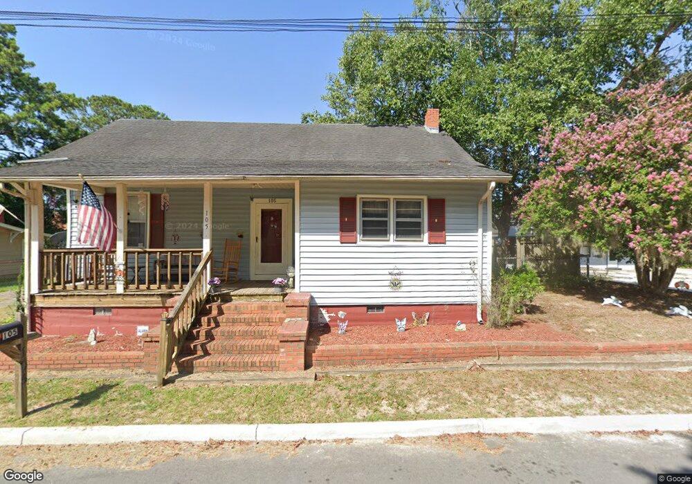
105 Buchanan St N Darlington, SC 29532
Estimated Value: $85,230 - $120,000
3
Beds
1
Bath
1,124
Sq Ft
$87/Sq Ft
Est. Value
About This Home
This home is located at 105 Buchanan St N, Darlington, SC 29532 and is currently estimated at $97,308, approximately $86 per square foot. 105 Buchanan St N is a home located in Darlington County with nearby schools including St. Johns Elementary School, Darlington Middle School, and Darlington High School.
Ownership History
Date
Name
Owned For
Owner Type
Purchase Details
Closed on
Jul 21, 2015
Sold by
Cox Frances B
Bought by
Riddle Billy Joe
Current Estimated Value
Home Financials for this Owner
Home Financials are based on the most recent Mortgage that was taken out on this home.
Original Mortgage
$48,979
Outstanding Balance
$38,271
Interest Rate
3.92%
Mortgage Type
New Conventional
Estimated Equity
$59,037
Purchase Details
Closed on
Aug 20, 2001
Sold by
Estate Of William P Cox and Coy Frances B
Bought by
Cox Frances B
Create a Home Valuation Report for This Property
The Home Valuation Report is an in-depth analysis detailing your home's value as well as a comparison with similar homes in the area
Home Values in the Area
Average Home Value in this Area
Purchase History
| Date | Buyer | Sale Price | Title Company |
|---|---|---|---|
| Riddle Billy Joe | $48,000 | -- | |
| Cox Frances B | -- | -- |
Source: Public Records
Mortgage History
| Date | Status | Borrower | Loan Amount |
|---|---|---|---|
| Open | Riddle Billy Joe | $48,979 |
Source: Public Records
Tax History Compared to Growth
Tax History
| Year | Tax Paid | Tax Assessment Tax Assessment Total Assessment is a certain percentage of the fair market value that is determined by local assessors to be the total taxable value of land and additions on the property. | Land | Improvement |
|---|---|---|---|---|
| 2024 | $456 | $2,250 | $280 | $1,970 |
| 2023 | $518 | $2,070 | $280 | $1,790 |
| 2022 | $518 | $2,070 | $280 | $1,790 |
| 2021 | $518 | $2,070 | $280 | $1,790 |
| 2020 | $411 | $2,070 | $280 | $1,790 |
| 2019 | $421 | $2,070 | $280 | $1,790 |
| 2018 | $356 | $1,940 | $280 | $1,660 |
| 2017 | $329 | $1,940 | $280 | $1,660 |
| 2016 | $304 | $1,940 | $280 | $1,660 |
| 2014 | $53 | $980 | $280 | $700 |
| 2013 | $35 | $980 | $280 | $700 |
Source: Public Records
Map
Nearby Homes
- 116 Cleveland St
- 113 Cleveland St
- 1011 Pearl St
- 0 Harry Byrd Hwy
- 500 Alexander St
- 1983 E Paces Trail
- 1970 E Paces Trail
- 1977 E Paces Trail
- 5183 Shallowford Rd
- 5189 Shallowford Rd
- 5177 Shallowford Rd
- 265 Syracuse St
- 527 Stanley Cir
- 2213 Highway 52
- 2225 Highway 52
- TBD Lamar Hwy
- 0 Stanley Cir
- 406 Pine St
- 640 Stanley Cir
- Lot 14 Wildshall Rd
- 107 Buchanan St N
- 103 Buchanan St N
- 106 N Twitty St
- 102 N Twitty St
- 708 Pearl St
- 728 Pearl St
- 712 Pearl St
- 776 Pearl St
- 865 Pearl St
- 707 Pearl St
- 0 Pearl St
- 108 Buchanan St S
- tbd Highway 340
- 108 Buchanan St N
- tbd Lot 4 Hwy 340
- 889 Pearl St
- TBD Lot3 S Carolina 340
- 104 Buchanan St S
- 103 S Twitty St
- 102 S Twitty St