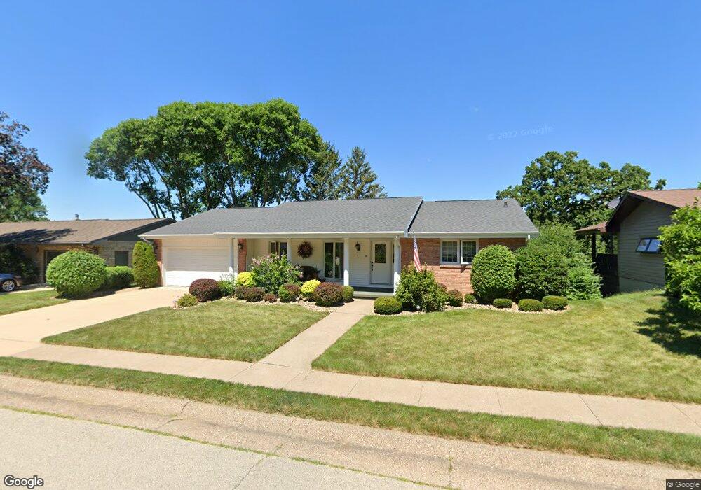
105 Croydon Crest Dubuque, IA 52001
Estimated Value: $338,142 - $367,000
3
Beds
3
Baths
2,274
Sq Ft
$155/Sq Ft
Est. Value
About This Home
This home is located at 105 Croydon Crest, Dubuque, IA 52001 and is currently estimated at $351,786, approximately $154 per square foot. 105 Croydon Crest is a home located in Dubuque County with nearby schools including Irving Elementary School, George Washington Middle School, and Dubuque Senior High School.
Ownership History
Date
Name
Owned For
Owner Type
Purchase Details
Closed on
Sep 14, 2023
Sold by
Asbury Mark W and Asbury Christine J
Bought by
Mark W Asbury Trust and Christine J Asbury Trust
Current Estimated Value
Purchase Details
Closed on
Oct 25, 2005
Sold by
Carlisle Mary L
Bought by
Asbury Mark W and Asbury Christine J
Home Financials for this Owner
Home Financials are based on the most recent Mortgage that was taken out on this home.
Original Mortgage
$120,000
Interest Rate
5.98%
Mortgage Type
New Conventional
Create a Home Valuation Report for This Property
The Home Valuation Report is an in-depth analysis detailing your home's value as well as a comparison with similar homes in the area
Purchase History
We collect this data history from publicly available records. To have your information removed, we recommend requesting removal directly through your county’s website.
| Date | Buyer | Sale Price | Title Company |
|---|---|---|---|
| Mark W Asbury Trust | -- | None Listed On Document | |
| Asbury Mark W | $198,000 | None Available |
Source: Public Records
Mortgage History
We collect this data history from publicly available records. To have your information removed, we recommend requesting removal directly through your county’s website.
| Date | Status | Borrower | Loan Amount |
|---|---|---|---|
| Previous Owner | Asbury Mark W | $120,000 |
Source: Public Records
Tax History
| Year | Tax Paid | Tax Assessment Tax Assessment Total Assessment is a certain percentage of the fair market value that is determined by local assessors to be the total taxable value of land and additions on the property. | Land | Improvement |
|---|---|---|---|---|
| 2025 | $4,476 | $356,800 | $37,600 | $319,200 |
| 2024 | $4,476 | $335,200 | $35,700 | $299,500 |
| 2023 | $4,436 | $335,200 | $35,700 | $299,500 |
| 2022 | $4,282 | $257,230 | $33,800 | $223,430 |
| 2021 | $4,106 | $257,230 | $33,800 | $223,430 |
| 2020 | $3,966 | $231,850 | $31,920 | $199,930 |
| 2019 | $3,980 | $231,850 | $31,920 | $199,930 |
| 2018 | $3,914 | $222,540 | $30,050 | $192,490 |
| 2017 | $3,718 | $222,540 | $30,050 | $192,490 |
| 2016 | $3,718 | $201,000 | $30,050 | $170,950 |
| 2015 | $3,638 | $201,000 | $30,050 | $170,950 |
| 2014 | $3,538 | $201,000 | $30,050 | $170,950 |
Source: Public Records
Map
Nearby Homes
- 2678 Beverly Ave
- 1629 McPoland Ave
- 105 Cherokee Dr
- 1594 Drexel Ave
- 1350 O'Hagen St
- 3063 Brunskill Rd
- 2163 Lombard St
- 2844 Oak Meadow Ct
- 1975 Hale St
- 2935 Van Buren St
- 1674 Avoca St
- 2628 University Ave
- 1821 Glendale Ct
- 1725 Bristol Dr
- 33 Meadow Ln
- 2002 Decorah St
- 1909 Asbury Rd
- 1776 Grace St
- 2335 Rosedale Ave
- 275 N Grandview Ave
- 99 Croydon Crest
- 135 Croydon Crest
- 2676 Mineral St
- 2680 Mineral St
- 93 Croydon Crest
- 155 Croydon Crest
- 2660 Mineral St
- 120 Croydon Crest
- 100 Croydon Crest
- 2690 Mineral St
- 140 Croydon Crest
- 96 Croydon Crest
- 2652 Mineral St
- 85 Croydon Crest
- 175 Croydon Crest
- 2702 Mineral St
- 90 Croydon Crest
- 160 Croydon Crest
- 99 Cambridge Ct
- 93 Cambridge Ct
Your Personal Tour Guide
Ask me questions while you tour the home.