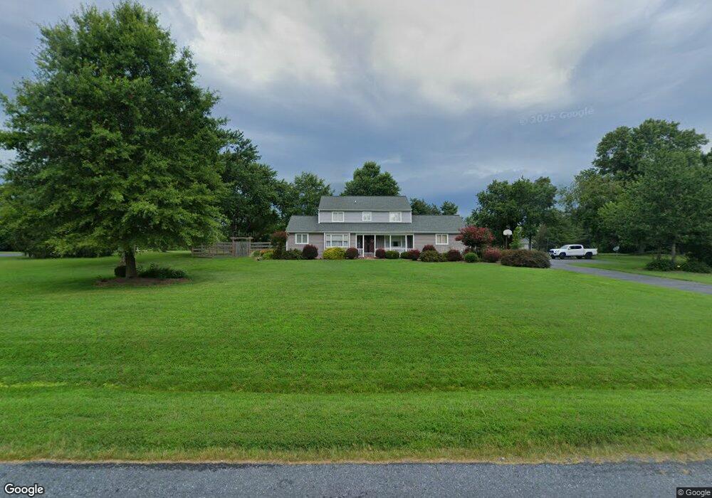
105 Indian Plantation Dr Stevensville, MD 21666
Estimated Value: $607,000 - $745,000
--
Bed
3
Baths
2,164
Sq Ft
$304/Sq Ft
Est. Value
About This Home
This home is located at 105 Indian Plantation Dr, Stevensville, MD 21666 and is currently estimated at $657,879, approximately $304 per square foot. 105 Indian Plantation Dr is a home located in Queen Anne's County with nearby schools including Matapeake Elementary School, Matapeake Middle School, and Kent Island High School.
Ownership History
Date
Name
Owned For
Owner Type
Purchase Details
Closed on
Jun 29, 1999
Sold by
Wroten C Curtis
Bought by
Veditz Frank B and Veditz Leigh A
Current Estimated Value
Purchase Details
Closed on
Jan 6, 1986
Sold by
Jesse Corp
Bought by
Wroten Wroten C and Wroten Mary A
Home Financials for this Owner
Home Financials are based on the most recent Mortgage that was taken out on this home.
Original Mortgage
$80,000
Interest Rate
10.81%
Create a Home Valuation Report for This Property
The Home Valuation Report is an in-depth analysis detailing your home's value as well as a comparison with similar homes in the area
Home Values in the Area
Average Home Value in this Area
Purchase History
| Date | Buyer | Sale Price | Title Company |
|---|---|---|---|
| Veditz Frank B | $219,000 | -- | |
| Wroten Wroten C | $21,700 | -- |
Source: Public Records
Mortgage History
| Date | Status | Borrower | Loan Amount |
|---|---|---|---|
| Previous Owner | Wroten Wroten C | $80,000 | |
| Closed | Veditz Frank B | -- |
Source: Public Records
Tax History Compared to Growth
Tax History
| Year | Tax Paid | Tax Assessment Tax Assessment Total Assessment is a certain percentage of the fair market value that is determined by local assessors to be the total taxable value of land and additions on the property. | Land | Improvement |
|---|---|---|---|---|
| 2025 | $4,331 | $466,600 | $0 | $0 |
| 2024 | $4,120 | $438,100 | $0 | $0 |
| 2023 | $3,918 | $409,600 | $179,400 | $230,200 |
| 2022 | $3,787 | $395,600 | $0 | $0 |
| 2021 | $3,586 | $381,600 | $0 | $0 |
| 2020 | $3,586 | $367,600 | $169,400 | $198,200 |
| 2019 | $3,430 | $351,367 | $0 | $0 |
| 2018 | $3,272 | $335,133 | $0 | $0 |
| 2017 | $3,119 | $318,900 | $0 | $0 |
| 2016 | -- | $313,067 | $0 | $0 |
| 2015 | $1,751 | $307,233 | $0 | $0 |
| 2014 | $1,751 | $301,400 | $0 | $0 |
Source: Public Records
Map
Nearby Homes
- 114 Queens Colony High Rd
- 303 Queens Colony High Rd
- 312 Queens Colony High Rd
- 0 Reynolds Ave
- 0 Allen Ave
- 410 5 Farms Dr
- 206 Columbia Ln
- 116 Mallard Dr
- 122 Mallard Dr
- 412 Five Farms Dr
- 303 Queen Anne Club Dr
- Lot 7 Maple Rd
- 103 Chesapeake Estates Dr
- 114 Birch Rd
- 124 Eareckson Ln
- 0 Chesapeake Estates Dr
- 100 Eareckson Ln
- 101 Oak St
- 116 Talbot Rd
- 107 Bay Dr
- 107 Indian Plantation Dr
- 103 Indian Plantation Dr
- 106 Indian Plantation Dr
- 104 Indian Plantation Dr
- 108 Indian Plantation Dr
- 111 Indian Plantation Dr
- 109 Indian Plantation Dr
- 117 Emory Cir
- 99 Indian Plantation Dr
- 101 Indian Plantation Dr
- 109 Shipping Creek Rd
- 104 Emory Cir
- 105 Shipping Creek Rd
- 107 Shipping Creek Rd
- 111 Shipping Creek Rd
- 110 Indian Plantation Dr
- 3265 Romancoke Rd
- 113 Indian Plantation Dr
- 103 Shipping Creek Rd
- 112 Indian Plantation Dr