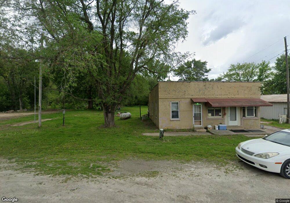
105 Main St Weston, MO 64098
Estimated Value: $132,799 - $247,000
2
Beds
2
Baths
1,088
Sq Ft
$191/Sq Ft
Est. Value
About This Home
This home is located at 105 Main St, Weston, MO 64098 and is currently estimated at $208,266, approximately $191 per square foot. 105 Main St is a home located in Platte County with nearby schools including Central Elementary School and West Platte High School.
Ownership History
Date
Name
Owned For
Owner Type
Purchase Details
Closed on
Jun 23, 2020
Sold by
Smither Pamela K and Smither Louis B
Bought by
Crockett Kyle Dennis
Current Estimated Value
Purchase Details
Closed on
Jul 24, 2015
Sold by
Smither Louis B and Smither
Bought by
Smither Louis B and Smither Pamela K
Purchase Details
Closed on
May 11, 2011
Sold by
Naatz David A and Mortensen Ginah K
Bought by
Smither Louis B and Smither Pamela K
Purchase Details
Closed on
Apr 28, 2006
Sold by
Carver Craig T
Bought by
Naatz David A and Mortensen Ginah K
Create a Home Valuation Report for This Property
The Home Valuation Report is an in-depth analysis detailing your home's value as well as a comparison with similar homes in the area
Purchase History
| Date | Buyer | Sale Price | Title Company |
|---|---|---|---|
| Crockett Kyle Dennis | -- | None Available | |
| Smither Louis B | -- | None Available | |
| Smither Louis B | -- | -- | |
| Naatz David A | -- | Platte County Title & Abstra |
Source: Public Records
Tax History
| Year | Tax Paid | Tax Assessment Tax Assessment Total Assessment is a certain percentage of the fair market value that is determined by local assessors to be the total taxable value of land and additions on the property. | Land | Improvement |
|---|---|---|---|---|
| 2025 | $473 | $7,210 | $950 | $6,260 |
| 2024 | $473 | $7,210 | $950 | $6,260 |
| 2023 | $473 | $7,210 | $950 | $6,260 |
| 2022 | $442 | $6,676 | $950 | $5,726 |
| 2021 | $440 | $6,676 | $950 | $5,726 |
| 2020 | $395 | $5,871 | $950 | $4,921 |
| 2019 | $395 | $5,871 | $950 | $4,921 |
| 2018 | $394 | $5,871 | $950 | $4,921 |
| 2017 | $399 | $5,871 | $950 | $4,921 |
| 2016 | $424 | $6,266 | $950 | $5,316 |
| 2015 | $422 | $6,266 | $950 | $5,316 |
| 2013 | $442 | $6,266 | $0 | $0 |
Source: Public Records
Map
Nearby Homes
- 34355 Iatan Rd
- 58.4 AC Brown Rd
- 00 Brown Rd
- 36680 Brown Rd
- 30105 Salem Rd
- 0 State Route M
- 19115 Missouri 45
- M Highway
- 27900 E Dye Store Rd
- 24200 N Us 45 Hwy
- 0 169th St
- 34287 167th St
- 27135 Webster Ct
- 18879 Kickapoo Ridge Rd
- 19104 Library Dr
- 908 Washington St
- 131 Ash St
- 22745 King Rd
- 20108 Grove Cir
- 605 4th St
Your Personal Tour Guide
Ask me questions while you tour the home.