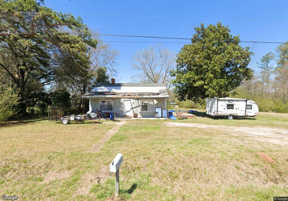
105 Marchman Dr Lagrange, GA 30241
Estimated Value: $20,000 - $503,000
2
Beds
1
Bath
832
Sq Ft
$320/Sq Ft
Est. Value
About This Home
This home is located at 105 Marchman Dr, Lagrange, GA 30241 and is currently estimated at $266,482, approximately $320 per square foot. 105 Marchman Dr is a home located in Troup County with nearby schools including Hollis Hand Elementary School, Franklin Forest Elementary School, and Ethel W. Kight Elementary School.
Ownership History
Date
Name
Owned For
Owner Type
Purchase Details
Closed on
Jan 13, 2023
Sold by
Mathis Christie L
Bought by
Won Min Investments Inc
Current Estimated Value
Purchase Details
Closed on
Aug 22, 2012
Sold by
Carson Patricia Ann
Bought by
Noles Christie Lynn
Purchase Details
Closed on
Dec 2, 1996
Sold by
Danny Mathis
Bought by
Carson Robert H and Carson Patricia A
Purchase Details
Closed on
Jan 1, 1945
Sold by
Harmon Charles C
Bought by
Danny Mathis
Create a Home Valuation Report for This Property
The Home Valuation Report is an in-depth analysis detailing your home's value as well as a comparison with similar homes in the area
Purchase History
| Date | Buyer | Sale Price | Title Company |
|---|---|---|---|
| Won Min Investments Inc | $175,000 | -- | |
| Noles Christie Lynn | -- | -- | |
| Carson Robert H | $2,000 | -- | |
| Danny Mathis | $2,100 | -- |
Source: Public Records
Tax History
| Year | Tax Paid | Tax Assessment Tax Assessment Total Assessment is a certain percentage of the fair market value that is determined by local assessors to be the total taxable value of land and additions on the property. | Land | Improvement |
|---|---|---|---|---|
| 2025 | $9,084 | $333,080 | $159,040 | $174,040 |
| 2024 | $4,337 | $159,040 | $159,040 | $0 |
| 2023 | $1,909 | $70,000 | $67,960 | $2,040 |
| 2022 | $387 | $13,880 | $7,520 | $6,360 |
| 2021 | $311 | $10,320 | $7,520 | $2,800 |
| 2020 | $288 | $9,560 | $7,520 | $2,040 |
| 2019 | $286 | $9,492 | $7,492 | $2,000 |
| 2018 | $280 | $9,292 | $7,492 | $1,800 |
| 2017 | $280 | $9,292 | $7,492 | $1,800 |
| 2016 | $283 | $9,398 | $7,492 | $1,906 |
| 2015 | $284 | $9,398 | $7,492 | $1,906 |
| 2014 | $281 | $9,298 | $7,492 | $1,806 |
| 2013 | -- | $14,378 | $7,492 | $6,886 |
Source: Public Records
Map
Nearby Homes
- 100 Dove Creek Ct
- 113 Pine Cir
- 200 River Meadow Dr
- 302 Glenhaven Dr Unit 2D
- 503 Headwater Ct Unit 4D
- 507 Headwater Ct Unit 6
- 502 Headwater Ct Unit 8D
- 129 Mallory Dr
- 109 Shenandoah Ln
- 111 Shenandoah Ln
- 106 Shenandoah Ln Unit 26E
- 106 Shenandoah Ln
- 240 River Meadow Dr
- 242 River Meadow Dr
- 249 River Meadow Dr
- 117 Shenandoah Ln Unit 22D
- 114 Shenandoah Ln
- 202 Freshwater Ct
- 204 Freshwater Ct
- 206 Freshwater Ct Unit 34E
- 103 Marchman Dr
- 109 Harmon Rd
- 107 Harmon Rd
- 104 Riley Rd
- 106 Riley Rd
- 105 Harmon Rd
- 203 Marchman Dr
- 103 Harmon Rd
- 204 Marchman Dr
- 204 Harmon Rd
- 201 Eichelberger Dr
- 105 Riley Rd
- 203 Eichelberger Dr
- 301 Harmon Rd
- 1415 Lafayette Pkwy
- 300 Eichelberger Dr
- 103 Riley Rd
- 1409 Lafayette Pkwy
- 205 Eichelberger Dr
- 207 Eichelberger Dr
Your Personal Tour Guide
Ask me questions while you tour the home.