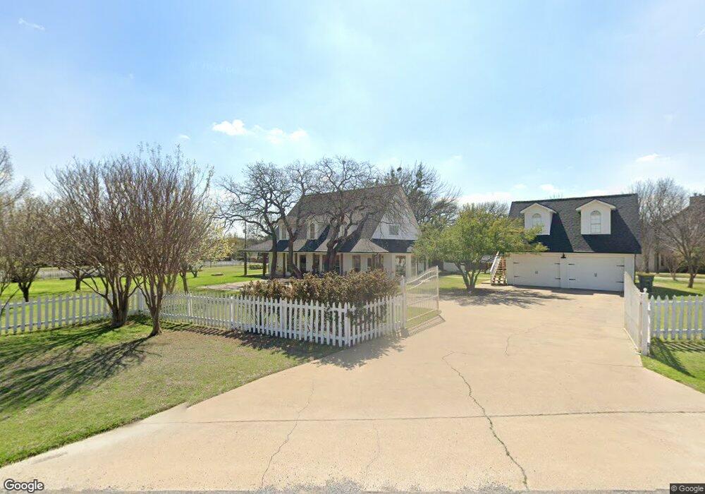
105 Mariah Dr Weatherford, TX 76087
Estimated Value: $533,000 - $610,000
3
Beds
3
Baths
2,723
Sq Ft
$210/Sq Ft
Est. Value
About This Home
This home is located at 105 Mariah Dr, Weatherford, TX 76087 and is currently estimated at $570,941, approximately $209 per square foot. 105 Mariah Dr is a home located in Parker County with nearby schools including Austin Elementary School, Hall Middle School, and Weatherford High School.
Ownership History
Date
Name
Owned For
Owner Type
Purchase Details
Closed on
Nov 27, 2013
Sold by
Wilkie Roy G and Hale Claudia
Bought by
Sellers Brian David and Sellers Katherine Irene
Current Estimated Value
Home Financials for this Owner
Home Financials are based on the most recent Mortgage that was taken out on this home.
Original Mortgage
$204,081
Outstanding Balance
$153,315
Interest Rate
4.34%
Mortgage Type
New Conventional
Estimated Equity
$417,626
Purchase Details
Closed on
Oct 26, 2006
Sold by
Pritchard Edmund W and Pritchard Karen
Bought by
Sellers Brian David and Katherine Irene
Home Financials for this Owner
Home Financials are based on the most recent Mortgage that was taken out on this home.
Original Mortgage
$35,800
Interest Rate
8.65%
Mortgage Type
Stand Alone Second
Purchase Details
Closed on
Oct 6, 2006
Bought by
Sellers Brian David and Katherine Irene
Home Financials for this Owner
Home Financials are based on the most recent Mortgage that was taken out on this home.
Original Mortgage
$35,800
Interest Rate
8.65%
Mortgage Type
Stand Alone Second
Purchase Details
Closed on
Sep 18, 2006
Sold by
Pritchard Edmund W and Pritchard Karen L
Bought by
American Escrow & Closing Company
Home Financials for this Owner
Home Financials are based on the most recent Mortgage that was taken out on this home.
Original Mortgage
$35,800
Interest Rate
8.65%
Mortgage Type
Stand Alone Second
Purchase Details
Closed on
Jul 8, 2004
Sold by
Dean Eric and Dean Robin
Bought by
Sellers Brian David and Katherine Irene
Purchase Details
Closed on
Jul 2, 2004
Sold by
Toholsky David J and Toholsky Michelle
Bought by
Sellers Brian David and Katherine Irene
Purchase Details
Closed on
May 14, 1997
Bought by
Sellers Brian David and Katherine Irene
Purchase Details
Closed on
Apr 30, 1993
Bought by
Sellers Brian David and Katherine Irene
Purchase Details
Closed on
Aug 7, 1990
Bought by
Sellers Brian David and Katherine Irene
Create a Home Valuation Report for This Property
The Home Valuation Report is an in-depth analysis detailing your home's value as well as a comparison with similar homes in the area
Home Values in the Area
Average Home Value in this Area
Purchase History
| Date | Buyer | Sale Price | Title Company |
|---|---|---|---|
| Sellers Brian David | -- | Providence Title | |
| Sellers Brian David | -- | -- | |
| Sellers Brian David | -- | -- | |
| Sellers Brian David | -- | -- | |
| Not Provided | -- | None Available | |
| American Escrow & Closing Company | -- | None Available | |
| Sellers Brian David | -- | -- | |
| Sellers Brian David | -- | -- | |
| Sellers Brian David | -- | -- | |
| Sellers Brian David | -- | -- | |
| Sellers Brian David | -- | -- |
Source: Public Records
Mortgage History
| Date | Status | Borrower | Loan Amount |
|---|---|---|---|
| Open | Sellers Brian David | $204,081 | |
| Previous Owner | American Escrow & Closing Company | $35,800 | |
| Previous Owner | Not Provided | $143,200 | |
| Previous Owner | American Escrow & Closing Company | $143,200 |
Source: Public Records
Tax History Compared to Growth
Tax History
| Year | Tax Paid | Tax Assessment Tax Assessment Total Assessment is a certain percentage of the fair market value that is determined by local assessors to be the total taxable value of land and additions on the property. | Land | Improvement |
|---|---|---|---|---|
| 2025 | $5,021 | $489,730 | $80,000 | $409,730 |
| 2024 | $5,021 | $373,384 | -- | -- |
| 2023 | $5,021 | $339,440 | $0 | $0 |
| 2022 | $5,739 | $308,590 | $50,000 | $258,590 |
| 2021 | $6,214 | $308,590 | $50,000 | $258,590 |
| 2020 | $5,769 | $285,150 | $30,000 | $255,150 |
| 2019 | $5,730 | $285,150 | $30,000 | $255,150 |
| 2018 | $5,255 | $265,900 | $30,000 | $235,900 |
| 2017 | $4,875 | $265,900 | $30,000 | $235,900 |
| 2016 | $4,432 | $199,650 | $30,000 | $169,650 |
| 2015 | $3,973 | $199,650 | $30,000 | $169,650 |
| 2014 | $3,998 | $198,140 | $30,000 | $168,140 |
Source: Public Records
Map
Nearby Homes
- 128 Southwinds Dr
- 1001 Trinity Oaks Rd
- 425 Fm 1708
- 8300 Norris Cir
- XXX Tin Top Rd
- 113 Oaks Springs Ln
- 145 Tobiano Trace
- 133 Tobiano Trace
- TBD Tbd
- 5444 Meadow Ridge Dr
- 650 Spring Creek Pkwy
- tbd Pinnacle Peak Ln
- TBD Thompson Rd
- 1001 Bluebonnet Ridge
- 4640 Tin Top Rd
- 6140 Meadow Ridge Dr
- 1019 Bluebonnet Ridge
- 0000 Walter Joseph Way
- 1020 Bluebonnet Ridge
- 2008 Walter Joseph Way
- 109 Mariah Dr
- 00 Southwinds Dr
- 121 Southwinds Dr
- 124 Southwinds Dr
- 106 Mariah Dr
- 129 Southwinds Dr
- 113 Mariah Dr
- 110 Mariah Dr
- 106 Southwinds Dr
- 114 Mariah Dr
- 125 Mariah Dr
- 109 Southwinds Dr
- 135 Southwinds Dr
- 129 Mariah Dr
- 118 Mariah Dr
- 132 Southwinds Dr
- 105 Southwinds Dr
- 137 Mariah Dr
- 143 Southwinds Dr
- 101 Mariah Dr