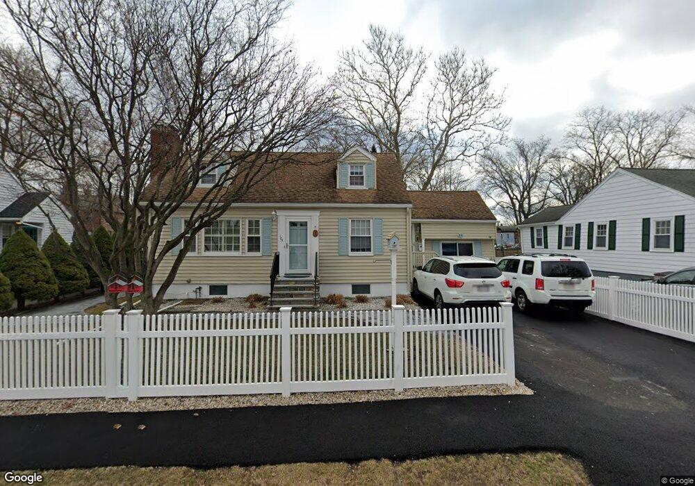
105 N Union St Arlington, MA 02474
East Arlington NeighborhoodEstimated Value: $904,000 - $1,115,000
3
Beds
2
Baths
1,670
Sq Ft
$612/Sq Ft
Est. Value
About This Home
This home is located at 105 N Union St, Arlington, MA 02474 and is currently estimated at $1,021,493, approximately $611 per square foot. 105 N Union St is a home located in Middlesex County with nearby schools including Thompson School, Ottoson Middle School, and Arlington High School.
Ownership History
Date
Name
Owned For
Owner Type
Purchase Details
Closed on
Feb 26, 2025
Sold by
Janelle Pauline F and Perno Janet T
Bought by
P Janelle & J T Perno Ft and Perno
Current Estimated Value
Purchase Details
Closed on
May 29, 1998
Sold by
Treat Lisa M and Rey Rodrique D
Bought by
Janelle Pauline F and Perno Janet T
Purchase Details
Closed on
Jul 22, 1994
Sold by
Dacosta Antonio T and Dacosta Madalena C
Bought by
Treat Lisa M and Rey Rodrigue D
Purchase Details
Closed on
Oct 19, 1990
Sold by
Hunter Daniel E
Bought by
Dacosta Antonio T
Create a Home Valuation Report for This Property
The Home Valuation Report is an in-depth analysis detailing your home's value as well as a comparison with similar homes in the area
Home Values in the Area
Average Home Value in this Area
Purchase History
| Date | Buyer | Sale Price | Title Company |
|---|---|---|---|
| P Janelle & J T Perno Ft | -- | None Available | |
| P Janelle & J T Perno Ft | -- | None Available | |
| Janelle Pauline F | $205,000 | -- | |
| Treat Lisa M | $177,000 | -- | |
| Dacosta Antonio T | $188,000 | -- | |
| Dacosta Antonio T | $188,000 | -- |
Source: Public Records
Mortgage History
| Date | Status | Borrower | Loan Amount |
|---|---|---|---|
| Previous Owner | Dacosta Antonio T | $337,500 | |
| Previous Owner | Dacosta Antonio T | $20,000 |
Source: Public Records
Tax History Compared to Growth
Tax History
| Year | Tax Paid | Tax Assessment Tax Assessment Total Assessment is a certain percentage of the fair market value that is determined by local assessors to be the total taxable value of land and additions on the property. | Land | Improvement |
|---|---|---|---|---|
| 2025 | $9,269 | $860,600 | $481,400 | $379,200 |
| 2024 | $8,501 | $802,700 | $457,300 | $345,400 |
| 2023 | $7,886 | $703,500 | $409,200 | $294,300 |
| 2022 | $7,609 | $666,300 | $385,100 | $281,200 |
| 2021 | $6,752 | $657,000 | $385,100 | $271,900 |
| 2020 | $7,268 | $657,100 | $385,100 | $272,000 |
| 2019 | $6,413 | $569,500 | $349,000 | $220,500 |
| 2018 | $6,690 | $551,500 | $331,000 | $220,500 |
| 2017 | $6,397 | $509,300 | $288,800 | $220,500 |
| 2016 | $5,980 | $467,200 | $246,700 | $220,500 |
| 2015 | $5,905 | $435,800 | $228,700 | $207,100 |
Source: Public Records
Map
Nearby Homes
- 6 Gordon Rd
- 2 Norcross Cir Unit 4
- 80 Broadway Unit 4C
- 80 Broadway Unit PH
- 166 Arlington St
- 79 Fairfax St Unit 79
- 395 Alewife Brook Pkwy Unit PH E
- 94 Rawson Rd Unit 94
- 69 Sterling St
- 327 Alewife Brook Pkwy Unit A
- 79 Park St
- 211 Arlington St
- 111 Sharon St Unit 1
- 99 Jerome St
- 78 Everett St
- 24 Park St Unit 2
- 65 Marathon St Unit L
- 31 Fairfax St
- 63 Marathon St Unit R
- 54 Marathon St Unit 1
- 101 N Union St
- 99 N Union St
- 109 N Union St
- 102 N Union St
- 95 N Union St
- 91 N Union St
- 126 N Union St
- 126 N Union St
- 5 Patrick St Unit 7
- 57 Patrick St
- 7 Patrick St
- 5 Patrick St Unit 2
- 5 Patrick St Unit 1
- 5 Patrick St
- 7 Patrick St Unit 2
- 6 Wheaton Rd
- 111 N Union St
- 115 N Union St
- 87 N Union St
- 9 Patrick St Unit 11