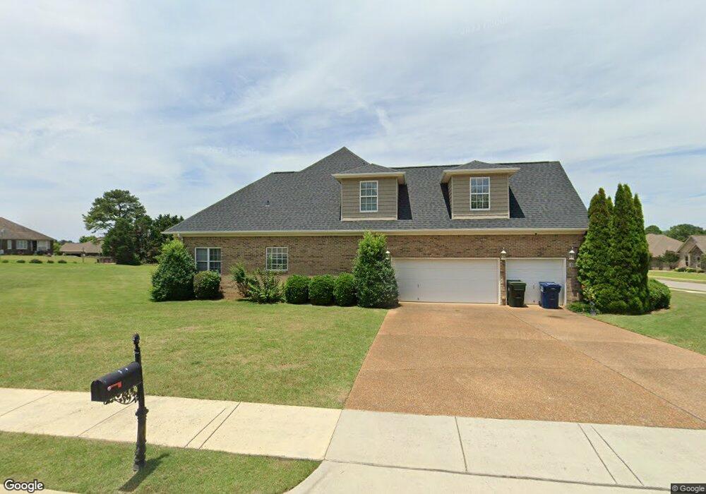
105 Southfork Dr Huntsville, AL 35811
Estimated Value: $491,475 - $546,000
4
Beds
4
Baths
3,284
Sq Ft
$158/Sq Ft
Est. Value
About This Home
This home is located at 105 Southfork Dr, Huntsville, AL 35811 and is currently estimated at $517,369, approximately $157 per square foot. 105 Southfork Dr is a home located in Madison County with nearby schools including Riverton Elementary School, Riverton Intermediate School, and Buckhorn Middle School.
Ownership History
Date
Name
Owned For
Owner Type
Purchase Details
Closed on
Jul 14, 2008
Sold by
Colonial Bank
Bought by
Stewart Patricia Y
Current Estimated Value
Home Financials for this Owner
Home Financials are based on the most recent Mortgage that was taken out on this home.
Original Mortgage
$240,000
Outstanding Balance
$156,394
Interest Rate
6.27%
Mortgage Type
New Conventional
Estimated Equity
$360,975
Purchase Details
Closed on
Apr 4, 2008
Sold by
Alabama Properties Llc
Bought by
Colonial Bank
Create a Home Valuation Report for This Property
The Home Valuation Report is an in-depth analysis detailing your home's value as well as a comparison with similar homes in the area
Home Values in the Area
Average Home Value in this Area
Purchase History
| Date | Buyer | Sale Price | Title Company |
|---|---|---|---|
| Stewart Patricia Y | -- | -- | |
| Colonial Bank | $211,407 | -- |
Source: Public Records
Mortgage History
| Date | Status | Borrower | Loan Amount |
|---|---|---|---|
| Open | Stewart Patricia Y | $240,000 |
Source: Public Records
Tax History Compared to Growth
Tax History
| Year | Tax Paid | Tax Assessment Tax Assessment Total Assessment is a certain percentage of the fair market value that is determined by local assessors to be the total taxable value of land and additions on the property. | Land | Improvement |
|---|---|---|---|---|
| 2024 | $1,272 | $43,420 | $3,000 | $40,420 |
| 2023 | $1,272 | $41,540 | $3,000 | $38,540 |
| 2022 | $1,324 | $37,840 | $3,000 | $34,840 |
| 2021 | $1,304 | $37,280 | $3,000 | $34,280 |
| 2020 | $1,163 | $33,410 | $3,000 | $30,410 |
| 2019 | $1,112 | $32,030 | $3,000 | $29,030 |
| 2018 | $1,039 | $30,020 | $0 | $0 |
| 2017 | $1,009 | $29,200 | $0 | $0 |
| 2016 | $1,009 | $29,200 | $0 | $0 |
| 2015 | $1,009 | $29,200 | $0 | $0 |
| 2014 | $1,084 | $31,340 | $0 | $0 |
Source: Public Records
Map
Nearby Homes
- 111 Saint Clair Ln
- 215 Saint Clair Ln
- 132 Southfork Dr
- 208 Dinner Tree Square
- 606 Bell Factory Rd
- 212 Dinner Tree Square
- 113 Richard Rd
- 115 Richard Rd
- 290 River Cove Rd
- 120 Mikaelas Way
- 208 Steppe Ct
- 229 Steppe Ct
- 292 Tercel Dr
- 294 Tercel Dr
- 206 Harlans Cir
- 113 Sidney Ruth Dr
- 109 Sidney Ruth Dr
- 111 Sidney Ruth Dr
- 115 Sidney Ruth Dr
- 125 Sidney Ruth Dr
- 102 Moore Springs Cir
- 0 Southfork Dr Unit 1099719
- 0 Southfork Dr Unit 1057958
- 0 Southfork Dr Unit 1065037
- 0 Southfork Dr Unit 860797
- 0 Southfork Dr Unit 1112852
- 104 Southfork Dr
- 106 Southfork Dr
- 104 Moore Springs Cir
- 101 Southfork Dr
- 111 Southfork Dr
- 102 Southfork Dr
- 115 Southfork Dr
- 103 Moore Springs Cir
- 108 Southfork Dr
- 105 Moore Springs Cir
- 100 Southfork Dr
- 108 Richard Rd
- 106 Moore Springs Cir
- 0001 Dinner Tree Square