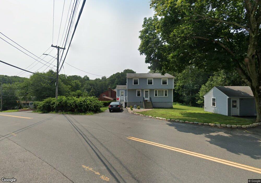
105 Stetson St Braintree, MA 02184
East Braintree NeighborhoodEstimated Value: $654,942 - $745,000
5
Beds
2
Baths
1,580
Sq Ft
$452/Sq Ft
Est. Value
About This Home
This home is located at 105 Stetson St, Braintree, MA 02184 and is currently estimated at $713,736, approximately $451 per square foot. 105 Stetson St is a home located in Norfolk County with nearby schools including Braintree High School, South Shore Christian Academy, and Sacred Heart Elementary School.
Ownership History
Date
Name
Owned For
Owner Type
Purchase Details
Closed on
Mar 25, 2014
Sold by
Riordan Michael F and Riordan Mary
Bought by
Riordan Mary
Current Estimated Value
Purchase Details
Closed on
Apr 29, 1966
Bought by
Riordan Mary
Create a Home Valuation Report for This Property
The Home Valuation Report is an in-depth analysis detailing your home's value as well as a comparison with similar homes in the area
Home Values in the Area
Average Home Value in this Area
Purchase History
| Date | Buyer | Sale Price | Title Company |
|---|---|---|---|
| Riordan Mary | -- | -- | |
| Riordan Mary | -- | -- | |
| Riordan Mary | -- | -- |
Source: Public Records
Tax History Compared to Growth
Tax History
| Year | Tax Paid | Tax Assessment Tax Assessment Total Assessment is a certain percentage of the fair market value that is determined by local assessors to be the total taxable value of land and additions on the property. | Land | Improvement |
|---|---|---|---|---|
| 2025 | $5,954 | $596,600 | $318,800 | $277,800 |
| 2024 | $5,349 | $564,200 | $297,300 | $266,900 |
| 2023 | $5,072 | $519,700 | $267,100 | $252,600 |
| 2022 | $4,913 | $493,800 | $241,200 | $252,600 |
| 2021 | $4,539 | $456,200 | $218,000 | $238,200 |
| 2020 | $4,303 | $436,400 | $198,200 | $238,200 |
| 2019 | $4,056 | $402,000 | $189,600 | $212,400 |
| 2018 | $3,964 | $376,100 | $172,300 | $203,800 |
| 2017 | $3,855 | $358,900 | $163,700 | $195,200 |
| 2016 | $3,530 | $321,500 | $137,900 | $183,600 |
| 2015 | $3,314 | $299,400 | $136,100 | $163,300 |
| 2014 | $3,147 | $275,600 | $124,100 | $151,500 |
Source: Public Records
Map
Nearby Homes
- 37 Lantern Ln
- 41 Lantern Ln
- 51 Faxon St
- 141 Commercial St Unit 9
- 15 Summer St
- 122 Washington St Unit 22
- 125 Allen St Unit A
- 11 Richmond St
- 23-25 Lindbergh Ave
- 16 Lindbergh Ave
- 19 Common St
- 124 Louise Rd
- 114 Broad St Unit D
- 19 Vine St Unit 3
- 19 Vine St Unit 1
- 298 Lisle St
- 33 Congress St
- 141 Hobart St
- 74 Magnolia St
- 67 Somerville Ave
- 5 Kenning Terrace
- 101 Stetson St
- 109 Bellevue Rd
- 112 Bellevue Rd
- 16 Pilgrim Rd
- 120 Stetson St
- 110 Bellevue Rd
- 15 Kenning Terrace
- 105 Bellevue Rd
- 124 Stetson St
- 137 Stetson St
- 108 Bellevue Rd
- 93 Stetson St
- 128 Stetson St
- 104 Bellevue Rd
- 101 Bellevue Rd
- 26 Pilgrim Rd
- 98 Stetson St
- 139 Stetson St
- 139-2 Stetson St