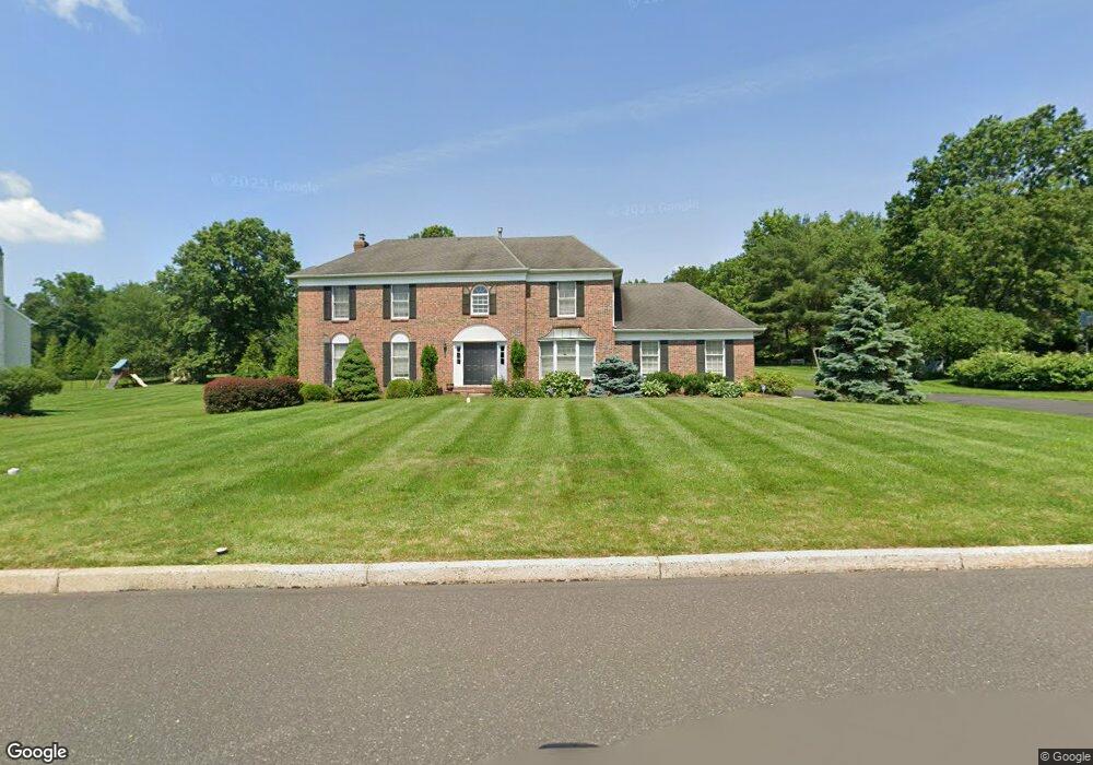
105 Windsong Dr Doylestown, PA 18901
Estimated Value: $890,991 - $991,000
4
Beds
3
Baths
2,558
Sq Ft
$361/Sq Ft
Est. Value
About This Home
This home is located at 105 Windsong Dr, Doylestown, PA 18901 and is currently estimated at $923,998, approximately $361 per square foot. 105 Windsong Dr is a home located in Bucks County with nearby schools including Groveland Elementary School, Tohickon Middle School, and Central Bucks High School-West.
Ownership History
Date
Name
Owned For
Owner Type
Purchase Details
Closed on
May 15, 1998
Sold by
Grenham William A and Grenham Christine M
Bought by
Ettorre Robert C
Current Estimated Value
Home Financials for this Owner
Home Financials are based on the most recent Mortgage that was taken out on this home.
Original Mortgage
$117,000
Interest Rate
7.03%
Purchase Details
Closed on
Oct 16, 1991
Bought by
Grenham William A and Grenham Christine M
Create a Home Valuation Report for This Property
The Home Valuation Report is an in-depth analysis detailing your home's value as well as a comparison with similar homes in the area
Home Values in the Area
Average Home Value in this Area
Purchase History
| Date | Buyer | Sale Price | Title Company |
|---|---|---|---|
| Ettorre Robert C | $317,000 | -- | |
| Grenham William A | $301,800 | -- |
Source: Public Records
Mortgage History
| Date | Status | Borrower | Loan Amount |
|---|---|---|---|
| Closed | Ettorre Robert C | $117,000 |
Source: Public Records
Tax History Compared to Growth
Tax History
| Year | Tax Paid | Tax Assessment Tax Assessment Total Assessment is a certain percentage of the fair market value that is determined by local assessors to be the total taxable value of land and additions on the property. | Land | Improvement |
|---|---|---|---|---|
| 2025 | $10,844 | $61,280 | $11,680 | $49,600 |
| 2024 | $10,844 | $61,280 | $11,680 | $49,600 |
| 2023 | $10,340 | $61,280 | $11,680 | $49,600 |
| 2022 | $10,225 | $61,280 | $11,680 | $49,600 |
| 2021 | $10,015 | $61,280 | $11,680 | $49,600 |
| 2020 | $9,969 | $61,280 | $11,680 | $49,600 |
| 2019 | $9,861 | $61,280 | $11,680 | $49,600 |
| 2018 | $9,831 | $61,280 | $11,680 | $49,600 |
| 2017 | $9,754 | $61,280 | $11,680 | $49,600 |
| 2016 | $9,693 | $61,280 | $11,680 | $49,600 |
| 2015 | -- | $61,280 | $11,680 | $49,600 |
| 2014 | -- | $61,280 | $11,680 | $49,600 |
Source: Public Records
Map
Nearby Homes
- 301 Windy Run Rd
- 100 Bishops Gate Ln Unit 67
- 194 Victoria Ct Unit 143
- 3711 Jacob Stout Rd Unit 5
- 114 Blackfriars Cir
- 3723 William Daves Rd
- 3765 William Daves Rd
- 4748 Bishop Cir
- 3838 Jacob Stout Rd
- 5437 Rinker Cir Unit 283
- 157 Pine Run Rd
- 3923 Ferry Rd
- 62 Constitution Ave
- 1 Gatehouse Ln
- 4 Old Colonial Dr Unit 254
- 90 Chapman Ave
- 418 North St
- 333 Dorset Ct Unit 333
- Lot 6 Henry Ct
- 215 N Franklin St
- 103 Windsong Dr
- 107 Windsong Dr
- 217 Southwind Dr
- 219 Southwind Dr
- 215 Southwind Dr
- 106 Windsong Dr
- 104 Windsong Dr
- 101 Windsong Dr
- 109 Windsong Dr
- 108 Windsong Dr
- 213 Southwind Dr
- 221 Southwind Dr
- 100 Windsong Dr
- 110 Windsong Dr
- 111 Windsong Dr
- 218 Southwind Dr
- 216 Southwind Dr
- 211 Southwind Dr
- 74 N Chapman Rd
- 1 S Pine St