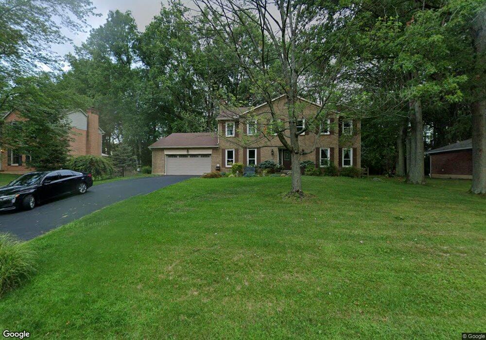
1050 Bridlepath Ln Loveland, OH 45140
Outer Loveland NeighborhoodEstimated Value: $472,000 - $519,000
4
Beds
3
Baths
2,572
Sq Ft
$191/Sq Ft
Est. Value
About This Home
This home is located at 1050 Bridlepath Ln, Loveland, OH 45140 and is currently estimated at $490,039, approximately $190 per square foot. 1050 Bridlepath Ln is a home located in Clermont County with nearby schools including Milford Senior High School, Milford Christian Academy, and St. Andrew - St. Elizabeth Ann Seton School.
Ownership History
Date
Name
Owned For
Owner Type
Purchase Details
Closed on
Aug 11, 2003
Sold by
Anderson Douglas M and Anderson Laura L
Bought by
Parker Steven G and Parker Joy C
Current Estimated Value
Home Financials for this Owner
Home Financials are based on the most recent Mortgage that was taken out on this home.
Original Mortgage
$184,000
Interest Rate
5.62%
Mortgage Type
Purchase Money Mortgage
Purchase Details
Closed on
Dec 20, 2002
Sold by
Springsteen David S and Springsteen Marylyn J
Bought by
Anderson Douglas M and Anderson Laura L
Home Financials for this Owner
Home Financials are based on the most recent Mortgage that was taken out on this home.
Original Mortgage
$120,000
Interest Rate
4.12%
Mortgage Type
Purchase Money Mortgage
Purchase Details
Closed on
Sep 8, 1993
Purchase Details
Closed on
Apr 3, 1991
Purchase Details
Closed on
Jul 1, 1989
Purchase Details
Closed on
Sep 1, 1985
Create a Home Valuation Report for This Property
The Home Valuation Report is an in-depth analysis detailing your home's value as well as a comparison with similar homes in the area
Home Values in the Area
Average Home Value in this Area
Purchase History
| Date | Buyer | Sale Price | Title Company |
|---|---|---|---|
| Parker Steven G | $230,000 | -- | |
| Anderson Douglas M | $220,000 | Classic Title Agency Inc | |
| -- | $176,800 | -- | |
| -- | $157,000 | -- | |
| -- | $159,900 | -- | |
| -- | $128,900 | -- |
Source: Public Records
Mortgage History
| Date | Status | Borrower | Loan Amount |
|---|---|---|---|
| Previous Owner | Parker Steven G | $184,000 | |
| Previous Owner | Anderson Douglas M | $120,000 | |
| Closed | Anderson Douglas M | $100,000 | |
| Closed | Parker Steven G | $34,500 |
Source: Public Records
Tax History Compared to Growth
Tax History
| Year | Tax Paid | Tax Assessment Tax Assessment Total Assessment is a certain percentage of the fair market value that is determined by local assessors to be the total taxable value of land and additions on the property. | Land | Improvement |
|---|---|---|---|---|
| 2024 | $6,115 | $132,200 | $21,910 | $110,290 |
| 2023 | $6,178 | $132,200 | $21,910 | $110,290 |
| 2022 | $5,849 | $95,100 | $15,750 | $79,350 |
| 2021 | $5,855 | $95,100 | $15,750 | $79,350 |
| 2020 | $5,616 | $95,100 | $15,750 | $79,350 |
| 2019 | $6,360 | $102,590 | $17,960 | $84,630 |
| 2018 | $6,362 | $102,590 | $17,960 | $84,630 |
| 2017 | $6,256 | $102,590 | $17,960 | $84,630 |
| 2016 | $6,130 | $89,990 | $15,750 | $74,240 |
| 2015 | $5,642 | $89,990 | $15,750 | $74,240 |
| 2014 | $5,642 | $89,990 | $15,750 | $74,240 |
| 2013 | $5,005 | $77,420 | $17,500 | $59,920 |
Source: Public Records
Map
Nearby Homes
- 1513 Charleston Ln
- 6211 Cook Rd
- 1113 Clover Field Dr
- 6141 Brandywine Ct
- 6149 Century Farm Dr
- 6379 Derbyshire Ln
- 6365 Ironwood Dr
- 1331 Harbor Cove
- 5933 Firm Stance Dr
- 1140 Weber Rd
- 2013 Weber Rd
- 6661 Paxton Guinea Rd
- 1803 Wheatfield Way
- 1706 Cottontail Dr
- 709 Middleton Way
- 899 Murle Ln
- 6211 Spires Dr
- 802 Andrea Dr
- 6469 Brittany Ln
- 945 Paul Vista Dr
- 1052 Bridlepath Ln
- 1048 Bridlepath Ln
- 1054 Bridlepath Ln
- 1046 Bridlepath Ln
- 6341 S Devonshire Dr
- 6230 Rustler Ct
- 6343 S Devonshire Dr
- 6339 S Devonshire Dr
- 1073 Tumbleweed Dr
- 6345 S Devonshire Dr
- 1056 Bridlepath Ln
- 1044 Bridlepath Ln
- 6337 S Devonshire Dr
- 6228 Rustler Ct
- 6235 Rustler Ct
- 1075 Tumbleweed Dr
- 6335 S Devonshire Dr
- 1058 Bridlepath Ln
- 1042 Bridlepath Ln
- 6347 S Devonshire Dr