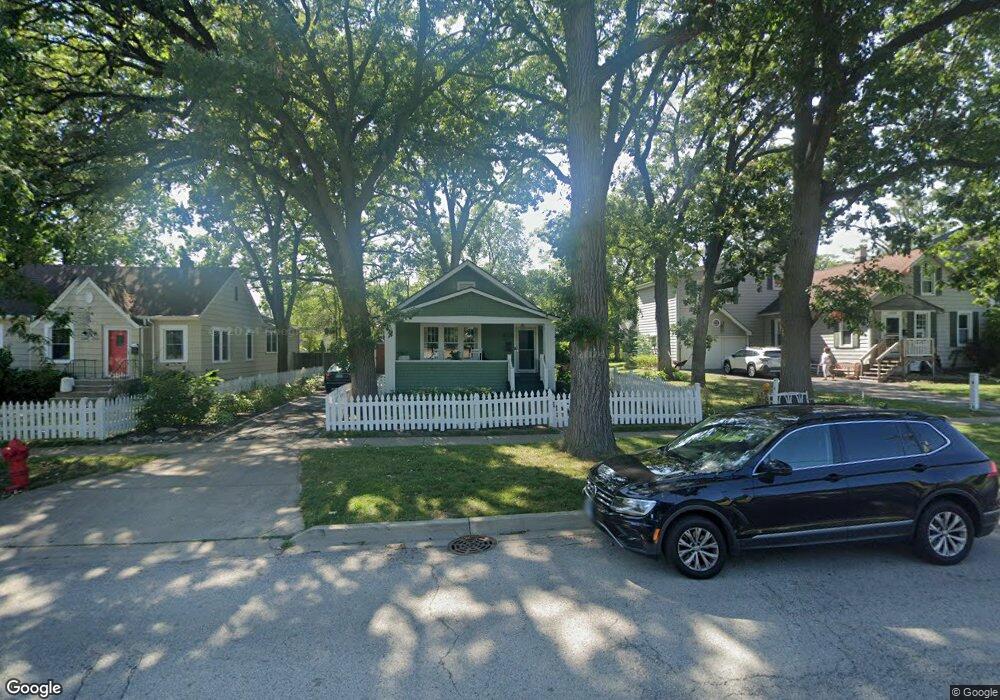
1050 Chestnut St Deerfield, IL 60015
Estimated Value: $380,953 - $419,000
2
Beds
2
Baths
984
Sq Ft
$407/Sq Ft
Est. Value
About This Home
This home is located at 1050 Chestnut St, Deerfield, IL 60015 and is currently estimated at $400,738, approximately $407 per square foot. 1050 Chestnut St is a home located in Lake County with nearby schools including Walden Elementary School, Alan B Shepard Middle School, and Deerfield High School.
Ownership History
Date
Name
Owned For
Owner Type
Purchase Details
Closed on
May 25, 2004
Sold by
Pagliai Bruce D
Bought by
Black Robert and Black Anne G
Current Estimated Value
Home Financials for this Owner
Home Financials are based on the most recent Mortgage that was taken out on this home.
Original Mortgage
$270,000
Outstanding Balance
$129,768
Interest Rate
5.75%
Mortgage Type
Unknown
Estimated Equity
$270,970
Create a Home Valuation Report for This Property
The Home Valuation Report is an in-depth analysis detailing your home's value as well as a comparison with similar homes in the area
Home Values in the Area
Average Home Value in this Area
Purchase History
| Date | Buyer | Sale Price | Title Company |
|---|---|---|---|
| Black Robert | $270,000 | -- |
Source: Public Records
Mortgage History
| Date | Status | Borrower | Loan Amount |
|---|---|---|---|
| Open | Black Robert | $270,000 |
Source: Public Records
Tax History
| Year | Tax Paid | Tax Assessment Tax Assessment Total Assessment is a certain percentage of the fair market value that is determined by local assessors to be the total taxable value of land and additions on the property. | Land | Improvement |
|---|---|---|---|---|
| 2024 | $6,841 | $84,041 | $29,785 | $54,256 |
| 2023 | $5,820 | $80,653 | $28,584 | $52,069 |
| 2022 | $5,820 | $67,388 | $30,702 | $36,686 |
| 2021 | $5,478 | $64,971 | $29,601 | $35,370 |
| 2020 | $5,269 | $65,107 | $29,663 | $35,444 |
| 2019 | $5,152 | $64,997 | $29,613 | $35,384 |
| 2018 | $4,980 | $65,464 | $31,387 | $34,077 |
| 2017 | $4,939 | $65,255 | $31,287 | $33,968 |
| 2016 | $4,791 | $62,788 | $30,104 | $32,684 |
| 2015 | $4,668 | $58,994 | $28,285 | $30,709 |
| 2014 | $4,607 | $57,584 | $31,652 | $25,932 |
| 2012 | $4,508 | $57,076 | $31,373 | $25,703 |
Source: Public Records
Map
Nearby Homes
- 1030 Chestnut St
- 1106 Waukegan Rd
- 826 Chestnut St
- 1285 Warwick Ct
- 1302 Hazel Ave
- 1151 Walden Ln
- 1440 Waukegan Rd
- 1165 Linden Ave
- 1423 Northwoods Rd
- 1420 Crowe Ave
- 926 Cedar St
- 1054 Broadmoor Place
- 1004 Broadmoor Place
- 1300 Knollwood Rd
- 950 Brookside Ln
- 1127 Kenton Rd
- 525 Mallard Ln
- 435 Kingston Terrace
- 1525 Hawthorne Place
- 534 Hermitage Dr
- 1058 Chestnut St
- 1040 Chestnut St
- 1100 Chestnut St
- 1045 Forest Ave
- 1034 Chestnut St
- 1051 Forest Ave
- 1041 Forest Ave
- 1035 Forest Ave
- 1055 Forest Ave
- 1029 Forest Ave
- 1059 Forest Ave
- 1104 Chestnut St
- 1025 Forest Ave
- 1063 Forest Ave
- 1110 Chestnut St
- 1026 Chestnut St
- 1021 Forest Ave
- 1067 Forest Ave
- 1020 Chestnut St
- 1015 Forest Ave
Your Personal Tour Guide
Ask me questions while you tour the home.