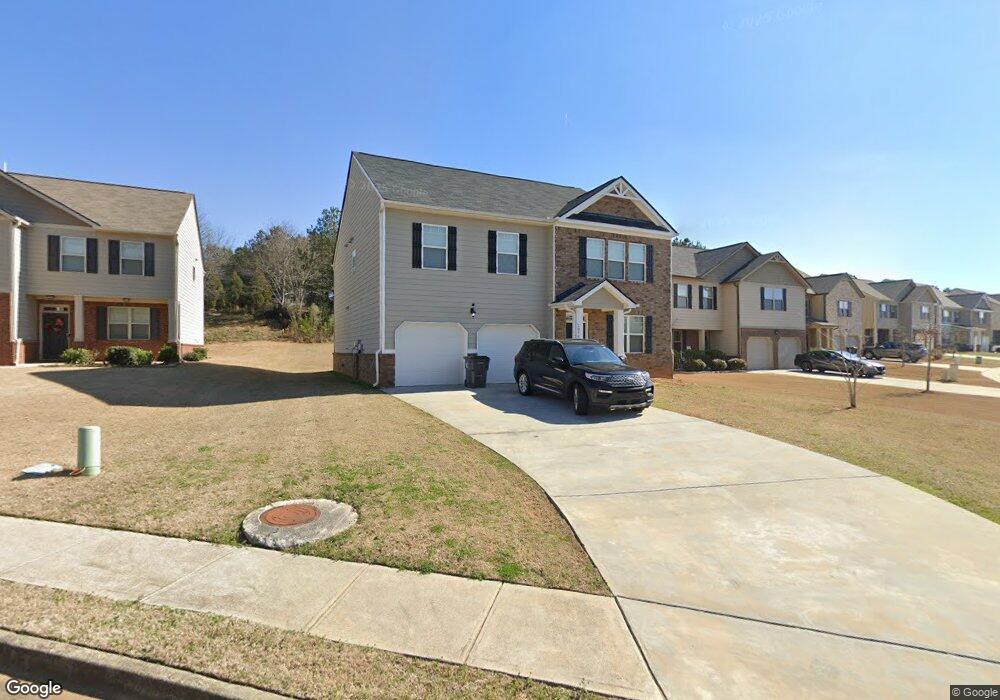
1050 Lear Dr Unit 345 Locust Grove, GA 30248
Estimated Value: $319,000 - $369,089
4
Beds
3
Baths
2,692
Sq Ft
$128/Sq Ft
Est. Value
About This Home
This home is located at 1050 Lear Dr Unit 345, Locust Grove, GA 30248 and is currently estimated at $343,272, approximately $127 per square foot. 1050 Lear Dr Unit 345 is a home located in Henry County with nearby schools including Locust Grove Elementary School, Locust Grove Middle School, and Locust Grove High School.
Ownership History
Date
Name
Owned For
Owner Type
Purchase Details
Closed on
Aug 28, 2020
Sold by
Basley Jermaine T
Bought by
Sneed Joseph
Current Estimated Value
Home Financials for this Owner
Home Financials are based on the most recent Mortgage that was taken out on this home.
Original Mortgage
$232,323
Outstanding Balance
$205,703
Interest Rate
2.9%
Mortgage Type
New Conventional
Estimated Equity
$137,569
Purchase Details
Closed on
Apr 25, 2019
Sold by
Dr Horton Inc
Bought by
Basley Jermaine T
Home Financials for this Owner
Home Financials are based on the most recent Mortgage that was taken out on this home.
Original Mortgage
$216,558
Interest Rate
4%
Purchase Details
Closed on
Aug 24, 2018
Sold by
Gdci Ga 6 Lp
Bought by
Dr Horton Inc
Create a Home Valuation Report for This Property
The Home Valuation Report is an in-depth analysis detailing your home's value as well as a comparison with similar homes in the area
Home Values in the Area
Average Home Value in this Area
Purchase History
| Date | Buyer | Sale Price | Title Company |
|---|---|---|---|
| Sneed Joseph | $230,000 | -- | |
| Sneed Joseph | $230,000 | -- | |
| Basley Jermaine T | $212,000 | -- | |
| Basley Jermaine T | $212,000 | -- | |
| Dr Horton Inc | $440,477 | -- | |
| Dr Horton Inc | $440,477 | -- |
Source: Public Records
Mortgage History
| Date | Status | Borrower | Loan Amount |
|---|---|---|---|
| Open | Sneed Joseph | $232,323 | |
| Previous Owner | Basley Jermaine T | $216,558 |
Source: Public Records
Tax History
| Year | Tax Paid | Tax Assessment Tax Assessment Total Assessment is a certain percentage of the fair market value that is determined by local assessors to be the total taxable value of land and additions on the property. | Land | Improvement |
|---|---|---|---|---|
| 2025 | $4,890 | $154,680 | $16,000 | $138,680 |
| 2024 | $4,890 | $135,040 | $16,000 | $119,040 |
| 2023 | $5,152 | $142,440 | $21,200 | $121,240 |
| 2022 | $4,190 | $114,880 | $21,200 | $93,680 |
| 2021 | $3,369 | $92,000 | $20,700 | $71,300 |
| 2020 | $3,100 | $84,560 | $12,000 | $72,560 |
| 2019 | $442 | $12,000 | $12,000 | $0 |
| 2018 | $0 | $8,000 | $8,000 | $0 |
| 2016 | $283 | $7,760 | $7,760 | $0 |
| 2015 | $190 | $5,040 | $5,040 | $0 |
| 2014 | $91 | $2,400 | $2,400 | $0 |
Source: Public Records
Map
Nearby Homes
- 116 Al Jennah Blvd
- 170 Al Jennah Blvd
- 161 Al Jennah Blvd
- 523 Carleton Place
- 2031 Theberton Trail
- 313 Harris Ave
- 409 Kirkland Dr
- 143 Massey Ln
- 269 Baumgard Way
- 188 Sophie Cir
- Cali Plan at Cedar Ridge - Locust Grove Station
- Belfort Plan at Cedar Ridge - Locust Grove Station
- Galen Plan at Cedar Ridge - Locust Grove Station
- Hayden Plan at Cedar Ridge - Locust Grove Station
- Packard Plan at Cedar Ridge - Locust Grove Station
- Flora Plan at Cedar Ridge - Locust Grove Station
- Penwell Plan at Cedar Ridge - Locust Grove Station
- 198 Aster Ave
- 194 Aster Ave
- 191 Aster Ave
- 1050 Lear Dr
- 1176 Werre Way
- 1052 Lear Dr
- 1172 Werre Way Unit 343
- 1172 Werre Way
- 1054 Lear Dr Unit 347
- 1053 Lear Dr
- 1053 Lear Dr Unit 303
- 1053 Lear Dr Unit Lot 1A
- 1169 Werre Way
- 1051 Lear Dr
- 1051 Lear Dr Unit 304
- 1168 Werre Way
- 1049 Lear Dr
- 1165 Werre Way
- 1164 Werre Way
- 1046 Lear Dr
- 1046 Lear Dr Unit 349
- 1325 Elmstead Place
- 1325 Elmstead Place Unit 302
Your Personal Tour Guide
Ask me questions while you tour the home.