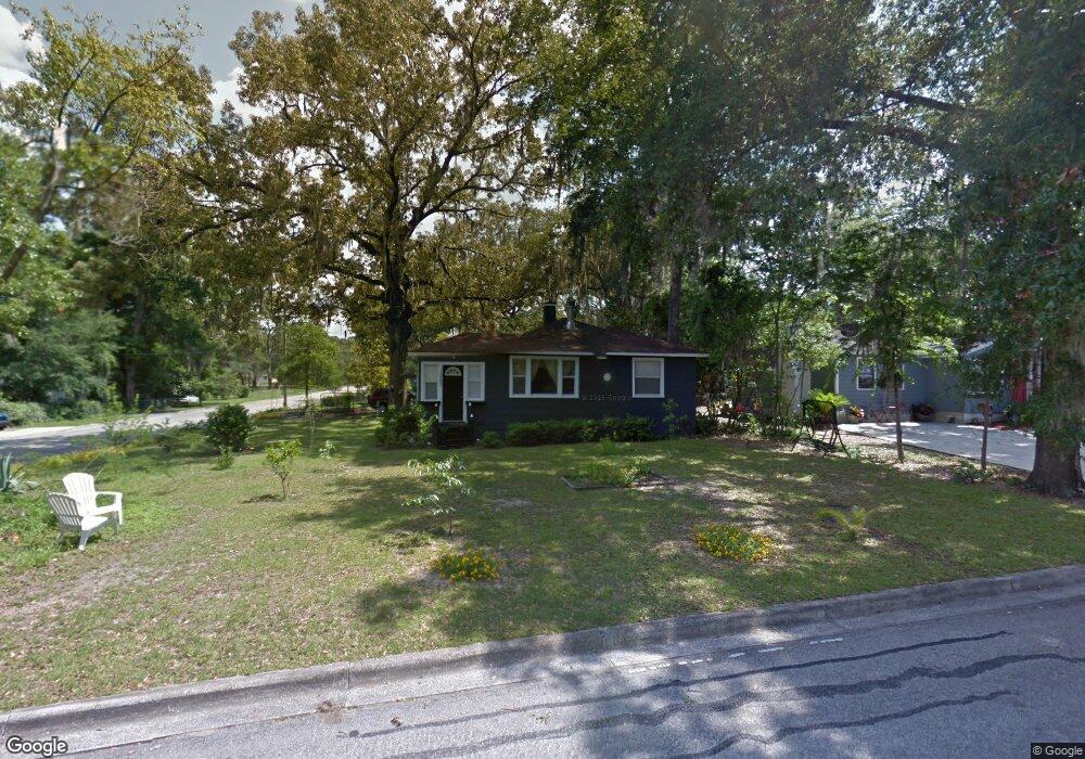
1050 NE 12th St Ocala, FL 34470
Northeast Ocala NeighborhoodEstimated Value: $164,000 - $250,000
3
Beds
2
Baths
1,421
Sq Ft
$147/Sq Ft
Est. Value
About This Home
This home is located at 1050 NE 12th St, Ocala, FL 34470 and is currently estimated at $209,185, approximately $147 per square foot. 1050 NE 12th St is a home located in Marion County with nearby schools including Wyomina Park Elementary School, Fort King Middle School, and Vanguard High School.
Ownership History
Date
Name
Owned For
Owner Type
Purchase Details
Closed on
Aug 9, 2024
Sold by
Sands Patricia R
Bought by
Asamusa Llc
Current Estimated Value
Purchase Details
Closed on
Oct 7, 2005
Sold by
Ulsh William A
Bought by
Sands Patricia R
Home Financials for this Owner
Home Financials are based on the most recent Mortgage that was taken out on this home.
Original Mortgage
$47,000
Interest Rate
7%
Mortgage Type
Purchase Money Mortgage
Purchase Details
Closed on
Apr 2, 2003
Sold by
Ulsh Kathy E
Bought by
Ulsh William Andrew
Create a Home Valuation Report for This Property
The Home Valuation Report is an in-depth analysis detailing your home's value as well as a comparison with similar homes in the area
Home Values in the Area
Average Home Value in this Area
Purchase History
| Date | Buyer | Sale Price | Title Company |
|---|---|---|---|
| Asamusa Llc | $220,000 | Brick City Title | |
| Sands Patricia R | $65,000 | -- | |
| Ulsh William Andrew | -- | -- |
Source: Public Records
Mortgage History
| Date | Status | Borrower | Loan Amount |
|---|---|---|---|
| Previous Owner | Sands Patricia R | $47,000 |
Source: Public Records
Tax History Compared to Growth
Tax History
| Year | Tax Paid | Tax Assessment Tax Assessment Total Assessment is a certain percentage of the fair market value that is determined by local assessors to be the total taxable value of land and additions on the property. | Land | Improvement |
|---|---|---|---|---|
| 2024 | $1,967 | $77,343 | -- | -- |
| 2023 | $1,938 | $70,312 | $0 | $0 |
| 2022 | $1,685 | $63,920 | $0 | $0 |
| 2021 | $1,587 | $109,835 | $37,500 | $72,335 |
| 2020 | $1,119 | $74,652 | $19,875 | $54,777 |
| 2019 | $926 | $53,501 | $9,375 | $44,126 |
| 2018 | $793 | $43,658 | $7,500 | $36,158 |
| 2017 | $802 | $43,426 | $7,500 | $35,926 |
| 2016 | $290 | $40,487 | $0 | $0 |
| 2015 | $289 | $40,206 | $0 | $0 |
| 2014 | $265 | $40,011 | $0 | $0 |
Source: Public Records
Map
Nearby Homes
- 1113 NE 11th St
- 1129 NE 12th St
- 1138 NE 12th St
- 910 NE 11th Ave
- 1137 NE 9th St
- 1152 NE 9th St
- 1136 NE 8th St
- 0 NE 8th Ave Unit MFROM700166
- 930 NE 14th Ave
- 1527 NE 13th Ave
- 1408 NE 15th Place
- 829 NE 15th Ave
- 430 NE 9th Ave
- 1116 NE 19th St
- 308 NE 12th Ave
- 1615 NE 9th St
- 1616 NE 16th Ave
- 1801 NE 14th Ave
- 0 NW 14th St Unit MFROM706382
- 0 NW 10th St
- 1044 NE 12th St
- 1108 NE 12th St
- 1036 NE 12th St
- 1043 NE 11th St
- 1051 NE 12th St
- 1114 NE 12th St
- 1043 NE 12th St
- 1035 NE 11th St
- 1030 NE 12th St
- 1107 NE 11th St
- 1105 NE 12th St
- 1037 NE 12th St
- 1029 NE 11th St
- 1124 NE 12th St
- 1113 NE 12th St
- 1022 NE 12th St
- 1027 NE 12th St
- 1130 NE 12th St
- 1121 NE 11th St
- 1021 NE 11th St