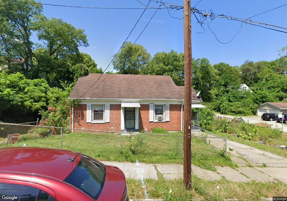
1051 Mcpherson Ave Cincinnati, OH 45205
East Price Hill NeighborhoodEstimated Value: $77,000 - $128,000
2
Beds
1
Bath
1,014
Sq Ft
$103/Sq Ft
Est. Value
About This Home
This home is located at 1051 Mcpherson Ave, Cincinnati, OH 45205 and is currently estimated at $103,986, approximately $102 per square foot. 1051 Mcpherson Ave is a home located in Hamilton County with nearby schools including Gilbert A. Dater High School, Western Hills High School, and Robert A. Taft Information Technology High School.
Ownership History
Date
Name
Owned For
Owner Type
Purchase Details
Closed on
Jun 11, 2025
Sold by
Larry Kay Construction Llc
Bought by
Escobar Rosani N Juarez and Escobar Mima E
Current Estimated Value
Purchase Details
Closed on
Mar 8, 2011
Sold by
Fannie Mae
Bought by
Larry Kay Construction Llc
Purchase Details
Closed on
Jan 5, 2011
Sold by
Alcorn Josephine
Bought by
Fannie Mae and Federal National Mortgage Association
Create a Home Valuation Report for This Property
The Home Valuation Report is an in-depth analysis detailing your home's value as well as a comparison with similar homes in the area
Home Values in the Area
Average Home Value in this Area
Purchase History
| Date | Buyer | Sale Price | Title Company |
|---|---|---|---|
| Escobar Rosani N Juarez | $65,230 | None Listed On Document | |
| Escobar Rosani N Juarez | $65,230 | None Listed On Document | |
| Larry Kay Construction Llc | $5,500 | Attorney | |
| Fannie Mae | $24,000 | Attorney |
Source: Public Records
Tax History Compared to Growth
Tax History
| Year | Tax Paid | Tax Assessment Tax Assessment Total Assessment is a certain percentage of the fair market value that is determined by local assessors to be the total taxable value of land and additions on the property. | Land | Improvement |
|---|---|---|---|---|
| 2024 | $1,458 | $22,831 | $2,881 | $19,950 |
| 2023 | $1,461 | $22,831 | $2,881 | $19,950 |
| 2022 | $722 | $10,032 | $2,538 | $7,494 |
| 2021 | $705 | $10,032 | $2,538 | $7,494 |
| 2020 | $707 | $10,032 | $2,538 | $7,494 |
| 2019 | $706 | $9,118 | $2,307 | $6,811 |
| 2018 | $707 | $9,118 | $2,307 | $6,811 |
| 2017 | $680 | $9,118 | $2,307 | $6,811 |
| 2016 | $151 | $1,870 | $1,523 | $347 |
| 2015 | $136 | $1,870 | $1,523 | $347 |
| 2014 | $136 | $1,870 | $1,523 | $347 |
| 2013 | $142 | $1,925 | $1,568 | $357 |
Source: Public Records
Map
Nearby Homes
- 1120 Carson Ave
- 1018 Sturm St
- 1215 Ridlen Ave
- 1232 Fairbanks Ave
- 963 Wells St
- 1248 Drott Ave
- 966 Fairbanks Ave
- 933 Enright Ave
- 3634 W Liberty St
- 1118 Seton Ave
- 1114 Seton Ave
- 1013 Del Monte Place
- 920 Enright Ave
- 1124 Elberon Ave
- 3742 Mayfield Ave
- 3744 Mayfield Ave
- 945 Oakland Ave
- 924 Fairbanks Ave
- 1605 Ross Ave
- 1043 Purcell Ave
- 1105 Mcpherson Ave
- 1049 Mcpherson Ave
- 3611 Lasalle Ave
- 1043 Mcpherson Ave
- 1111 Mcpherson Ave
- 1052 Mcpherson Ave
- 1056 Mcpherson Ave
- 3610 Laclede Ave
- 1046 Mcpherson Ave
- 3617 Lasalle Ave
- 3612 Laclede Ave
- 3608 Lasalle Ave
- 1039 Mcpherson Ave
- 1115 Mcpherson Ave
- 3612 Lasalle Ave
- 1044 Mcpherson Ave
- 3614 Laclede Ave
- 1100 Mcpherson Ave
- 1040 Mcpherson Ave
- 3616 Lasalle Ave