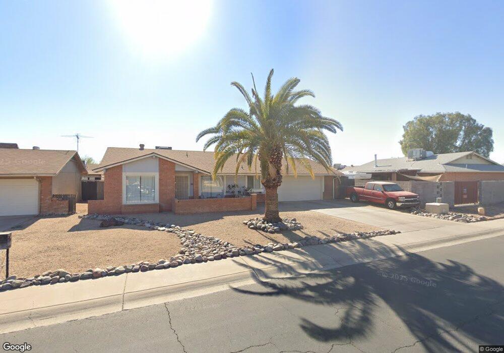
10517 W Royal Palm Rd Peoria, AZ 85345
Estimated Value: $285,281 - $364,000
--
Bed
2
Baths
1,386
Sq Ft
$240/Sq Ft
Est. Value
About This Home
This home is located at 10517 W Royal Palm Rd, Peoria, AZ 85345 and is currently estimated at $333,320, approximately $240 per square foot. 10517 W Royal Palm Rd is a home located in Maricopa County with nearby schools including Country Meadows Elementary School, Raymond S. Kellis, and Brighton Charter School.
Ownership History
Date
Name
Owned For
Owner Type
Purchase Details
Closed on
Jan 5, 2012
Sold by
Diamond Brenda Marie
Bought by
Savage Brenda Marie
Current Estimated Value
Purchase Details
Closed on
Jan 27, 1999
Sold by
Diamond Terry Arthur
Bought by
Diamond Brenda Marie
Purchase Details
Closed on
Sep 28, 1994
Sold by
Brewster C Wesley
Bought by
Diamond Terry Arthur and Diamond Brenda Marie
Home Financials for this Owner
Home Financials are based on the most recent Mortgage that was taken out on this home.
Original Mortgage
$59,050
Interest Rate
8.92%
Mortgage Type
Seller Take Back
Create a Home Valuation Report for This Property
The Home Valuation Report is an in-depth analysis detailing your home's value as well as a comparison with similar homes in the area
Home Values in the Area
Average Home Value in this Area
Purchase History
| Date | Buyer | Sale Price | Title Company |
|---|---|---|---|
| Savage Brenda Marie | -- | None Available | |
| Diamond Brenda Marie | -- | -- | |
| Diamond Terry Arthur | $66,000 | Chicago Title Insurance Co |
Source: Public Records
Mortgage History
| Date | Status | Borrower | Loan Amount |
|---|---|---|---|
| Previous Owner | Diamond Terry Arthur | $59,050 |
Source: Public Records
Tax History Compared to Growth
Tax History
| Year | Tax Paid | Tax Assessment Tax Assessment Total Assessment is a certain percentage of the fair market value that is determined by local assessors to be the total taxable value of land and additions on the property. | Land | Improvement |
|---|---|---|---|---|
| 2025 | $784 | $10,065 | -- | -- |
| 2024 | $772 | $9,586 | -- | -- |
| 2023 | $772 | $24,850 | $4,970 | $19,880 |
| 2022 | $756 | $19,170 | $3,830 | $15,340 |
| 2021 | $809 | $16,970 | $3,390 | $13,580 |
| 2020 | $817 | $15,930 | $3,180 | $12,750 |
| 2019 | $790 | $14,170 | $2,830 | $11,340 |
| 2018 | $764 | $12,630 | $2,520 | $10,110 |
| 2017 | $764 | $11,170 | $2,230 | $8,940 |
| 2016 | $757 | $10,150 | $2,030 | $8,120 |
| 2015 | $706 | $9,380 | $1,870 | $7,510 |
Source: Public Records
Map
Nearby Homes
- 10516 W Griswold Rd
- 8161 N 107th Ave Unit 109
- 10620 W Northern Ave Unit 5
- 8131 N 107th Ave Unit 74
- 8131 N 107th Ave Unit 66
- 8131 N 107th Ave Unit 82
- 8101 N 107th Ave Unit 23
- 8140 N 107th Ave Unit 125
- 8140 N 107th Ave Unit 287
- 8435 N 104th Dr Unit 3
- 10512 W Butler Dr
- 10815 W Northern Ave Unit 102
- 8301 N 103rd Ave Unit 177
- 8301 N 103rd Ave Unit 53
- 8582 N 107th Ln
- 10603 W Ruth Ave
- 7607 N 107th Dr
- 11003 W Griswold Rd
- 8566 N 108th Ln
- 10512 W Ruth Ave
- 10513 W Royal Palm Rd
- 8113 N 105th Ln
- 10514 W Harmont Dr
- 8109 N 105th Ln
- 8106 N 105th Dr
- 10509 W Royal Palm Rd
- 10518 W Royal Palm Rd
- 10522 W Royal Palm Rd
- 10514 W Royal Palm Rd
- 10510 W Harmont Dr
- 8105 N 105th Ln Unit 4
- 10510 W Royal Palm Rd
- 10526 W Royal Palm Rd
- 10439 W Royal Palm Rd
- 8102 N 105th Dr Unit 4
- 10506 W Harmont Dr
- 8114 N 105th Ln
- 8101 N 105th Ln
- 10513 W Griswold Rd
- 8110 N 105th Ln