


1052 Bones Chapel Rd Whitesboro, TX 76273
Estimated payment $49,520/month
Highlights
- 185.12 Acre Lot
- Agricultural
- Lot Has A Rolling Slope
- Pasture
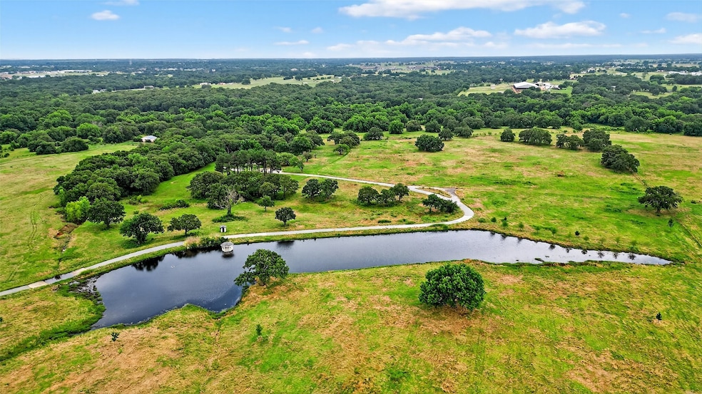
About This Lot
North Texas Executive retreat waiting for your finishing touches. 185 Plus acres with frontage on Bones Chapel Rd and Anderson Rd. Winding Mineral Creek flows throughout the property with mature Pecan and Oaks. Property is ready for your dream build with several picturesque sites with views abound. Located just minutes to Whitesboro, Sherman, Lake Texoma and the DFW metroplex. Several ponds located throughout the property all stocked with several species of fish. Property has two small houses for help, family or income producing.
Listing Agent
SANDERS REAL ESTATE Brokerage Phone: 903-564-3426 License #0501531 Listed on: 06/23/2025
Property Details
Property Type
- Land
Est. Annual Taxes
- $10,386
Lot Details
- 185.12 Acre Lot
- Lot Has A Rolling Slope
- Cleared Lot
- Zoning described as unzoned
Home Design
- Ranch Property
Schools
- Whitesboro Elementary School
- Whitesboro High School
Farming
- Agricultural
- Pasture
Utilities
- Cable TV Available
Listing and Financial Details
- Assessor Parcel Number 218748
Map
Home Values in the Area
Average Home Value in this Area
Tax History
| Year | Tax Paid | Tax Assessment Tax Assessment Total Assessment is a certain percentage of the fair market value that is determined by local assessors to be the total taxable value of land and additions on the property. | Land | Improvement |
|---|---|---|---|---|
| 2025 | $10,386 | $595,513 | $23,397 | $572,116 |
| 2024 | $10,386 | $656,376 | $0 | $0 |
| 2023 | $9,340 | $665,470 | $19,719 | $645,751 |
| 2022 | $10,029 | $630,889 | $10,771 | $620,118 |
| 2021 | $9,620 | $624,783 | $10,428 | $614,355 |
| 2020 | $9,252 | $499,717 | $11,210 | $488,507 |
| 2019 | $13,313 | $670,980 | $10,280 | $660,700 |
| 2018 | $13,034 | $643,150 | $9,325 | $633,825 |
| 2017 | $12,301 | $613,690 | $9,695 | $603,995 |
| 2016 | $11,083 | $539,304 | $9,638 | $529,666 |
| 2015 | $8,379 | $438,487 | $9,532 | $428,955 |
| 2014 | -- | $421,442 | $9,547 | $411,895 |
Property History
| Date | Event | Price | Change | Sq Ft Price |
|---|---|---|---|---|
| 06/23/2025 06/23/25 | For Sale | $8,999,000 | -- | -- |
Mortgage History
| Date | Status | Loan Amount | Loan Type |
|---|---|---|---|
| Closed | $1,500,000 | New Conventional | |
| Closed | $600,000 | Construction |
Source: North Texas Real Estate Information Systems (NTREIS)
MLS Number: 20978341
APN: 218748
Disclaimer: Certain information contained herein is derived from information provided by parties other than Homes.com. All information provided is deemed reliable, but is not guaranteed to be accurate and should be independently verified.
![]() Listing information provided in part by the North Texas Real Estate Information Systems, Inc, for personal, non-commercial use by viewers of this site and may not be reproduced or redistributed. All information is deemed reliable but not guaranteed. Copyright © NTREIS 2025. All rights reserved
Listing information provided in part by the North Texas Real Estate Information Systems, Inc, for personal, non-commercial use by viewers of this site and may not be reproduced or redistributed. All information is deemed reliable but not guaranteed. Copyright © NTREIS 2025. All rights reserved
- TBD Bones Chapel Rd
- 167 W Acres Rd
- 400 Wild Wood Ln
- 3285 Roland Rd
- 262 Briar Creek Rd
- 873 Anderson Rd
- US U S Highway 82
- 11362 U S Highway 82
- 316 Charlie Dr
- 707 N Union St
- 718 N Union St
- 20ac Us Hwy 377
- 704 N Union St
- 706 Abney St
- 115 D St
- 605 Abney St
- 701 Park Place
- 407 N Jordan St
- TBD Center Park Dr
- 703 W Main St
