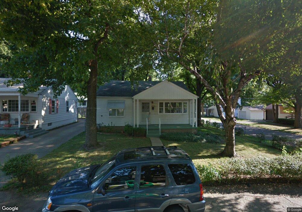
1052 Evans Ct Decatur, IL 62522
Garfield Park NeighborhoodEstimated Value: $38,000 - $55,000
Studio
--
Bath
896
Sq Ft
$49/Sq Ft
Est. Value
About This Home
This home is located at 1052 Evans Ct, Decatur, IL 62522 and is currently estimated at $44,134, approximately $49 per square foot. 1052 Evans Ct is a home located in Macon County with nearby schools including Stephen Decatur Middle School, St. Patrick School, and Teen Challenge-Home For Girls.
Ownership History
Date
Name
Owned For
Owner Type
Purchase Details
Closed on
Aug 26, 2018
Sold by
Henn Thomas and Henn Donna
Bought by
Wicker Joy
Current Estimated Value
Purchase Details
Closed on
Sep 14, 2012
Sold by
Aubort Mitchell Alan
Bought by
Henn Thomas and Henn Donna J
Purchase Details
Closed on
Mar 2, 2012
Sold by
Boylson Nancy A and Kuny Sally H
Bought by
Aubert Mitchell Alan
Purchase Details
Closed on
Jul 22, 2011
Sold by
Henry Mildred L
Bought by
Boylson Nancy A and Boylsonkuny Sally H
Create a Home Valuation Report for This Property
The Home Valuation Report is an in-depth analysis detailing your home's value as well as a comparison with similar homes in the area
Home Values in the Area
Average Home Value in this Area
Purchase History
| Date | Buyer | Sale Price | Title Company |
|---|---|---|---|
| Wicker Joy | -- | None Available | |
| Henn Thomas | $24,500 | None Available | |
| Aubert Mitchell Alan | $14,000 | None Available | |
| Boylson Nancy A | -- | None Available |
Source: Public Records
Tax History
| Year | Tax Paid | Tax Assessment Tax Assessment Total Assessment is a certain percentage of the fair market value that is determined by local assessors to be the total taxable value of land and additions on the property. | Land | Improvement |
|---|---|---|---|---|
| 2024 | $706 | $9,102 | $437 | $8,665 |
| 2023 | $726 | $8,780 | $422 | $8,358 |
| 2022 | $746 | $8,282 | $390 | $7,892 |
| 2021 | $750 | $7,735 | $365 | $7,370 |
| 2020 | $775 | $7,377 | $349 | $7,028 |
| 2019 | $784 | $7,377 | $349 | $7,028 |
| 2018 | $841 | $8,003 | $169 | $7,834 |
| 2017 | $861 | $8,217 | $174 | $8,043 |
| 2016 | $877 | $8,301 | $176 | $8,125 |
| 2015 | $833 | $8,154 | $173 | $7,981 |
| 2014 | $899 | $9,382 | $202 | $9,180 |
| 2013 | $929 | $9,735 | $210 | $9,525 |
Source: Public Records
Map
Nearby Homes
- 1034 N Oakland Ave
- 1059 W Packard St
- 977 N Oakland Ave
- 947 N Hill Ave
- 1213 W Marietta St
- 1329 N Walnut Grove Ave
- 1097 W Green St
- 960 W Green St
- 1429 N Walnut Grove Ave
- 979 W Cerro Gordo St
- 1124 W Cushing St
- 1557 W Center St
- 1653 N Maple Ave
- 1535 N Mcclellan Ave
- 1659 N Maple Ave
- 958 W William St
- 1415 N Dennis Ave
- 254 N Pine St
- 235 N Park Place
- 254 W Leafland Ave
- 1062 Evans Ct
- 1044 Kyle Ct
- 1053 Evans Ct
- 1024 Kyle Ct
- 1069 W Packard St
- 1039 W Packard St
- 1061 Evans Ct
- 1073 W Packard St
- 1014 Kyle Ct
- 1078 Evans Ct
- 1069 Evans Ct
- 1075 W Packard St
- 1081 Evans Ct
- 1062 W Packard St
- 1031 W Packard St
- 1052 N Oakland Ave
- 1054 W Marietta St
- 1060 W Marietta St
- 1056 W Packard St
- 1044 W Packard St
Your Personal Tour Guide
Ask me questions while you tour the home.