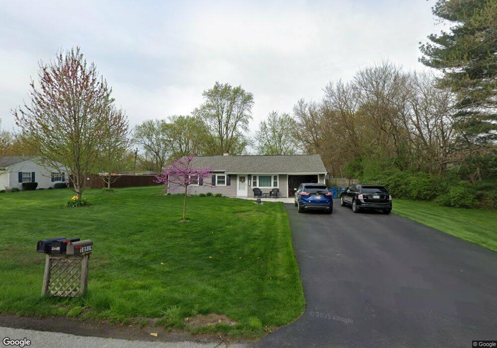
10522 Baker St Crown Point, IN 46307
Estimated Value: $235,997 - $282,000
3
Beds
1
Bath
1,224
Sq Ft
$210/Sq Ft
Est. Value
About This Home
This home is located at 10522 Baker St, Crown Point, IN 46307 and is currently estimated at $257,249, approximately $210 per square foot. 10522 Baker St is a home located in Lake County with nearby schools including Timothy Ball Elementary School, Robert Taft Middle School, and Crown Point High School.
Ownership History
Date
Name
Owned For
Owner Type
Purchase Details
Closed on
Jul 2, 2018
Bought by
Burgans Derik E
Current Estimated Value
Home Financials for this Owner
Home Financials are based on the most recent Mortgage that was taken out on this home.
Original Mortgage
$124,357
Outstanding Balance
$107,443
Interest Rate
4.55%
Estimated Equity
$149,806
Create a Home Valuation Report for This Property
The Home Valuation Report is an in-depth analysis detailing your home's value as well as a comparison with similar homes in the area
Home Values in the Area
Average Home Value in this Area
Purchase History
| Date | Buyer | Sale Price | Title Company |
|---|---|---|---|
| Burgans Derik E | -- | -- |
Source: Public Records
Mortgage History
| Date | Status | Borrower | Loan Amount |
|---|---|---|---|
| Open | Burgans Derik E | $124,357 | |
| Closed | Burgans Derik E | -- |
Source: Public Records
Tax History Compared to Growth
Tax History
| Year | Tax Paid | Tax Assessment Tax Assessment Total Assessment is a certain percentage of the fair market value that is determined by local assessors to be the total taxable value of land and additions on the property. | Land | Improvement |
|---|---|---|---|---|
| 2024 | $1,318 | $168,000 | $36,500 | $131,500 |
| 2023 | $1,330 | $159,900 | $36,500 | $123,400 |
| 2022 | $1,330 | $157,600 | $36,500 | $121,100 |
| 2021 | $1,165 | $148,800 | $28,100 | $120,700 |
| 2020 | $1,252 | $150,600 | $28,100 | $122,500 |
| 2019 | $1,329 | $149,400 | $28,100 | $121,300 |
| 2018 | $1,360 | $146,200 | $28,100 | $118,100 |
| 2017 | $1,266 | $137,800 | $28,100 | $109,700 |
| 2016 | $1,191 | $131,400 | $28,100 | $103,300 |
| 2014 | $1,137 | $137,700 | $28,200 | $109,500 |
| 2013 | $1,150 | $138,800 | $28,100 | $110,700 |
Source: Public Records
Map
Nearby Homes
- 10813 Lane St
- 10710 Porter St
- 7830 W 106th Ln
- 7770 W 106th Ln
- 3725 W 105th Ave
- 10729 Hanley St
- 5496 W 107th Ct
- 3604 W 104th Place
- 700 Meadow Ln
- 771 Kenmare Pkwy
- 767 Kenmare Pkwy
- 621 Pratt St
- 11217 Burr Parcel 2 St
- 11341 Lakewood St
- 5121 W 113th Ave
- 11224 Durbin Place
- 114 S Chase Dr
- 1667 Chalone Ct
- 301 Hoffman St
- 312 Summit Park Ct S
- 10528 Baker St
- 10518 Baker St
- 10523 Baker Place
- 10529 Baker Place
- 10519 Baker St
- 10608 Baker St
- 10523 Baker St
- 10515 Baker St
- 10527 Baker St
- 10603 Baker Place
- 10612 Baker St
- 10607 Baker St
- 10607 Baker Place
- 10505 Baker Place
- 10522 Baker Place
- 10528 Baker Place
- 10611 Baker St
- 10514 Baker Place
- 10611 Baker Place
- 10618 Baker St