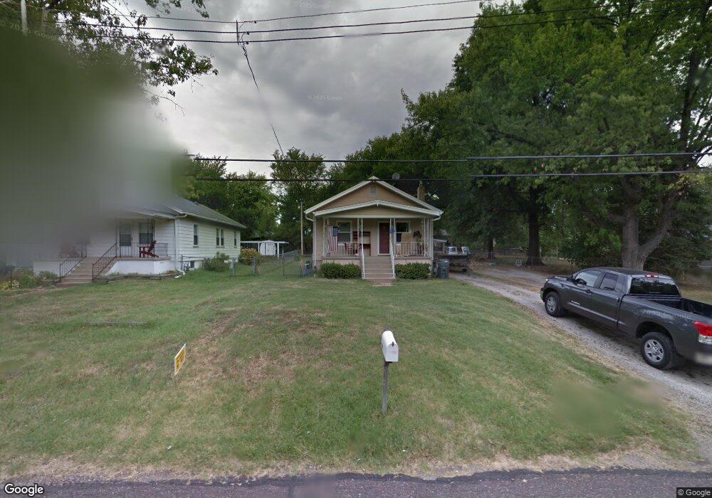
10533 Thorpe Ave Saint Louis, MO 63114
Estimated Value: $110,000 - $167,000
1
Bed
1
Bath
768
Sq Ft
$170/Sq Ft
Est. Value
About This Home
This home is located at 10533 Thorpe Ave, Saint Louis, MO 63114 and is currently estimated at $130,716, approximately $170 per square foot. 10533 Thorpe Ave is a home located in St. Louis County with nearby schools including Buder Elementary School, Hoech Middle School, and Ritenour Senior High School.
Ownership History
Date
Name
Owned For
Owner Type
Purchase Details
Closed on
May 15, 1998
Sold by
Dorran Walter R and Dorran Daisy M
Bought by
Roberts Wesley J and Roberts Christine A
Current Estimated Value
Home Financials for this Owner
Home Financials are based on the most recent Mortgage that was taken out on this home.
Original Mortgage
$37,321
Outstanding Balance
$7,299
Interest Rate
7.11%
Mortgage Type
FHA
Estimated Equity
$123,417
Create a Home Valuation Report for This Property
The Home Valuation Report is an in-depth analysis detailing your home's value as well as a comparison with similar homes in the area
Home Values in the Area
Average Home Value in this Area
Purchase History
| Date | Buyer | Sale Price | Title Company |
|---|---|---|---|
| Roberts Wesley J | -- | -- |
Source: Public Records
Mortgage History
| Date | Status | Borrower | Loan Amount |
|---|---|---|---|
| Open | Roberts Wesley J | $37,321 |
Source: Public Records
Tax History Compared to Growth
Tax History
| Year | Tax Paid | Tax Assessment Tax Assessment Total Assessment is a certain percentage of the fair market value that is determined by local assessors to be the total taxable value of land and additions on the property. | Land | Improvement |
|---|---|---|---|---|
| 2025 | $1,591 | $24,410 | $4,160 | $20,250 |
| 2024 | $1,591 | $19,490 | $3,190 | $16,300 |
| 2023 | $1,561 | $19,490 | $3,190 | $16,300 |
| 2022 | $1,555 | $17,180 | $3,670 | $13,510 |
| 2021 | $1,550 | $17,180 | $3,670 | $13,510 |
| 2020 | $1,289 | $13,250 | $3,670 | $9,580 |
| 2019 | $1,283 | $13,250 | $3,670 | $9,580 |
| 2018 | $1,010 | $9,270 | $3,210 | $6,060 |
| 2017 | $962 | $9,270 | $3,210 | $6,060 |
| 2016 | $969 | $9,010 | $2,870 | $6,140 |
| 2015 | $960 | $9,010 | $2,870 | $6,140 |
| 2014 | $1,393 | $13,430 | $740 | $12,690 |
Source: Public Records
Map
Nearby Homes
- 10651 Thorpe Ave
- 10515 Clarendon Ave
- 2703 Ashby Rd
- 3001 Ashby Rd
- 3005 Ashby Rd
- 10719 Thorpe Ave
- 3000 Ashby Rd
- 10730 Wurdack Ave
- 2454 Prouhet Ave
- 2450 Fowler Ave
- 10235 Midland Blvd
- 2430 Prouhet Ave
- 2412 Silkwood Dr
- 10627 Canter Way
- 3134 O Hare Dr
- 3113 Pearl Harbor Dr
- 10490 Canter Way
- 10525 Hobday Ave
- 10810 Hobday Ave
- 2729 Link Rd
- 10527 Thorpe Ave
- 10541 Thorpe Ave
- 10552 Decker Ave
- 10525 Thorpe Ave
- 10548 Decker Ave
- 10556 Decker Ave
- 10601 Thorpe Ave
- 10521 Thorpe Ave
- 10536 Thorpe Ave
- 10534 Thorpe Ave
- 10538 Thorpe Ave
- 10540 Decker Ave
- 10566 Decker Ave
- 10530 Thorpe Ave
- 10636 Decker Ave
- 10554 Thorpe Ave
- 10536 Decker Ave
- 10615 Thorpe Ave
- 10526 Thorpe Ave
- 10519 Thorpe Ave