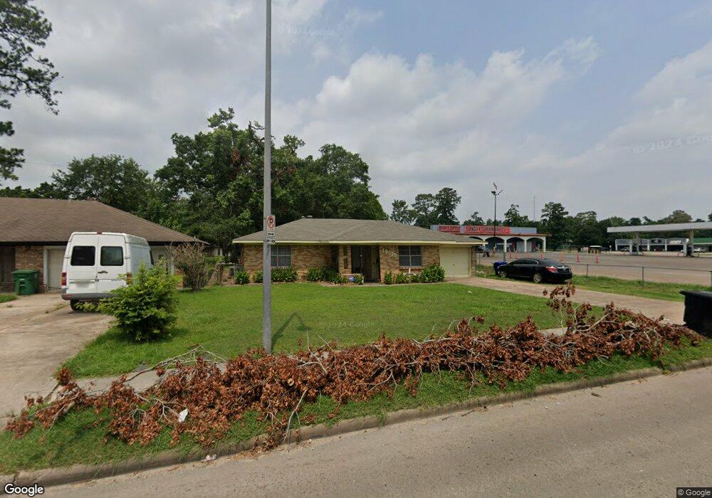
10535 Homestead Rd Houston, TX 77016
East Little York NeighborhoodEstimated Value: $141,000 - $166,000
3
Beds
1
Bath
1,099
Sq Ft
$143/Sq Ft
Est. Value
About This Home
This home is located at 10535 Homestead Rd, Houston, TX 77016 and is currently estimated at $157,105, approximately $142 per square foot. 10535 Homestead Rd is a home located in Harris County with nearby schools including Shadydale Elementary School, Forest Brook Middle, and North Forest High School.
Ownership History
Date
Name
Owned For
Owner Type
Purchase Details
Closed on
Mar 16, 1994
Sold by
Ledet Phillip and Ledet Lela
Bought by
Boudreaux James and Boudreaux Laura
Current Estimated Value
Home Financials for this Owner
Home Financials are based on the most recent Mortgage that was taken out on this home.
Original Mortgage
$35,050
Interest Rate
6.96%
Mortgage Type
Seller Take Back
Create a Home Valuation Report for This Property
The Home Valuation Report is an in-depth analysis detailing your home's value as well as a comparison with similar homes in the area
Home Values in the Area
Average Home Value in this Area
Purchase History
| Date | Buyer | Sale Price | Title Company |
|---|---|---|---|
| Boudreaux James | -- | -- |
Source: Public Records
Mortgage History
| Date | Status | Borrower | Loan Amount |
|---|---|---|---|
| Closed | Boudreaux James | $35,050 |
Source: Public Records
Tax History Compared to Growth
Tax History
| Year | Tax Paid | Tax Assessment Tax Assessment Total Assessment is a certain percentage of the fair market value that is determined by local assessors to be the total taxable value of land and additions on the property. | Land | Improvement |
|---|---|---|---|---|
| 2025 | $1,622 | $141,079 | $55,939 | $85,140 |
| 2024 | $1,622 | $146,723 | $39,486 | $107,237 |
| 2023 | $1,622 | $161,069 | $39,486 | $121,583 |
| 2022 | $1,611 | $152,397 | $39,486 | $112,911 |
| 2021 | $1,551 | $93,610 | $26,324 | $67,286 |
| 2020 | $1,465 | $78,142 | $17,769 | $60,373 |
| 2019 | $1,391 | $61,085 | $11,254 | $49,831 |
| 2018 | $0 | $49,987 | $11,254 | $38,733 |
| 2017 | $1,264 | $49,987 | $11,254 | $38,733 |
| 2016 | $1,193 | $47,172 | $11,254 | $35,918 |
| 2015 | $990 | $45,298 | $11,254 | $34,044 |
| 2014 | $990 | $38,510 | $11,254 | $27,256 |
Source: Public Records
Map
Nearby Homes
- 10538 Royal Oaks Dr
- 10526 Hollyglen Dr
- 10430 Royal Oaks Dr
- 10535 Hollyglen Dr
- 10434 Envoy St
- 10317 Kelburn Dr
- 7226 Gore Dr
- 5905 Langley Rd
- 7210 Colton St
- 10313 Blades St
- 10221 Bretton Dr
- 10201 Homestead Rd
- 7818 Laurel Gem Dr
- 7827 Laurel Gem Dr
- 7823 Laurel Gem Dr
- 7821 Laurel Gem Dr
- 7812 Laurel Gem Dr
- 7830 Laurel Gem Dr
- 7824 Laurel Gem Dr
- 7819 Laurel Gem Dr
- 10531 Homestead Rd
- 10527 Homestead Rd
- 10526 Rockaway Dr
- 10523 Homestead Rd
- 10530 Rockaway Dr
- 10534 Homestead Rd
- 10534 Homestead Rd Unit 1
- 10522 Rockaway Dr
- 10536 Homestead Rd
- 10530 Homestead Rd
- 10538 Homestead Rd
- 10542 Homestead Rd
- 10519 Homestead Rd
- 10518 Rockaway Dr
- 10522 Homestead Rd
- 10534 Rockaway Dr
- 10515 Homestead Rd
- 10518 Homestead Rd
- 10533 Kelburn Dr
- 10537 Kelburn Dr