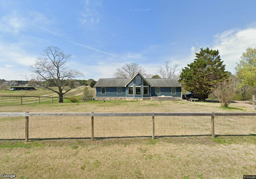
1054 Mcintire Rd Rock Spring, GA 30739
Rock Spring NeighborhoodEstimated Value: $310,000 - $341,000
Studio
2
Baths
1,554
Sq Ft
$209/Sq Ft
Est. Value
About This Home
This home is located at 1054 Mcintire Rd, Rock Spring, GA 30739 and is currently estimated at $324,928, approximately $209 per square foot. 1054 Mcintire Rd is a home located in Walker County with nearby schools including Rock Spring Elementary School, Lafayette High School, and Alice M Daley Adventist School.
Ownership History
Date
Name
Owned For
Owner Type
Purchase Details
Closed on
Apr 18, 2025
Sold by
Kephart Gray
Bought by
Kephart Gray and Kephart Wade
Current Estimated Value
Purchase Details
Closed on
Jan 22, 2021
Sold by
Holt Doris C
Bought by
Mccurdy Gray Anna
Purchase Details
Closed on
Aug 9, 2013
Sold by
Price James Curry
Bought by
Holt Doris C
Purchase Details
Closed on
Oct 14, 2011
Sold by
Price James C
Bought by
Pendley Debra P
Purchase Details
Closed on
Aug 14, 2006
Sold by
Price James C
Bought by
Haught Brian Keith
Purchase Details
Closed on
Jul 6, 2001
Sold by
Price James C and Price Mary
Bought by
Price James C
Purchase Details
Closed on
Dec 3, 1993
Sold by
Hall James B
Bought by
Price James C and Price Mary
Purchase Details
Closed on
Jan 1, 1972
Bought by
Hall James B
Create a Home Valuation Report for This Property
The Home Valuation Report is an in-depth analysis detailing your home's value as well as a comparison with similar homes in the area
Home Values in the Area
Average Home Value in this Area
Purchase History
| Date | Buyer | Sale Price | Title Company |
|---|---|---|---|
| Kephart Gray | -- | -- | |
| Mccurdy Gray Anna | -- | -- | |
| Holt Doris C | $132,500 | -- | |
| Pendley Debra P | -- | -- | |
| Haught Brian Keith | $62,000 | -- | |
| Price James C | -- | -- | |
| Price James C | $27,000 | -- | |
| Hall James B | -- | -- |
Source: Public Records
Tax History
| Year | Tax Paid | Tax Assessment Tax Assessment Total Assessment is a certain percentage of the fair market value that is determined by local assessors to be the total taxable value of land and additions on the property. | Land | Improvement |
|---|---|---|---|---|
| 2025 | $2,189 | $100,733 | $8,988 | $91,745 |
| 2024 | $2,276 | $100,733 | $8,988 | $91,745 |
| 2023 | $2,538 | $111,389 | $9,939 | $101,450 |
| 2022 | $1,440 | $92,212 | $4,394 | $87,818 |
| 2021 | $1,214 | $76,669 | $4,394 | $72,275 |
| 2020 | $620 | $51,095 | $4,570 | $46,525 |
| 2019 | $646 | $51,095 | $4,570 | $46,525 |
| 2018 | $1,352 | $51,095 | $4,570 | $46,525 |
| 2017 | $826 | $51,095 | $4,570 | $46,525 |
| 2016 | $516 | $51,280 | $4,570 | $46,710 |
| 2015 | $575 | $52,593 | $8,112 | $44,481 |
| 2014 | $466 | $52,593 | $8,112 | $44,481 |
| 2013 | -- | $62,451 | $8,112 | $54,339 |
Source: Public Records
Map
Nearby Homes
- 1306 Mcintire Rd
- 1314 Mcintire Rd
- 0 Georgia 95
- 1801 Colbert Hollow Rd
- 6391 Georgia 95
- 505 Round Pond Rd
- 322 Chloe Dr
- 190 Chloe Dr
- 329 Pinewood Dr
- 172 Pinewood Dr
- 876 Wood Station Rd
- 0 Tarvin Rd Unit 1523862
- 9 Stonecrest
- 155 Ash Ln
- 200 Ash Ln
- 15590 Alabama Hwy
- 0 Temperance Hall Rd Unit 10506446
- 0 Temperance Hall Rd Unit 1526704
- 146 Hinton Ln
- 1585 E Reed Rd
- 1128 Mcintire Rd
- 1119 Mcintire Rd
- 1106 Mcintire Rd
- 1098 Mcintyre Rd
- 1149 Mcintire Rd
- 1205 Mcintire Rd
- 1040 Mcintire Rd
- 1116 Mcintire Rd
- 68 Evans Hill Ln
- 1252 Mcintire Rd
- 1110 Mcintire Rd
- 180 Evans Hill Ln
- 848 Mcintire Rd
- 898 Mcintire Rd
- 1290 Mcintire Rd
- 62 Woods Meadow Dr
- 62 Woods Meadow Dr Unit LOT 15
- 23 Woods Meadow Dr
- 89 Woods Meadow Dr
- 181 Maple Leaf Dr
Your Personal Tour Guide
Ask me questions while you tour the home.