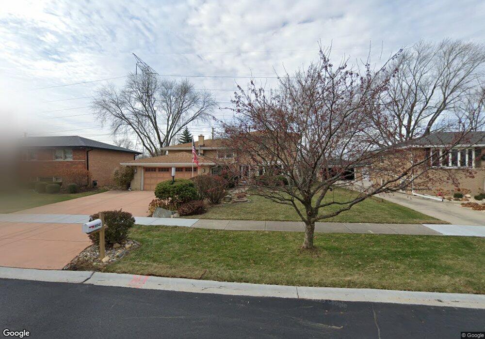
10542 S Michael Dr Palos Hills, IL 60465
Estimated Value: $381,000 - $503,000
5
Beds
3
Baths
2,572
Sq Ft
$177/Sq Ft
Est. Value
About This Home
This home is located at 10542 S Michael Dr, Palos Hills, IL 60465 and is currently estimated at $454,703, approximately $176 per square foot. 10542 S Michael Dr is a home located in Cook County with nearby schools including Sorrick Elementary School, Oak Ridge Elementary School, and H H Conrady Jr High School.
Ownership History
Date
Name
Owned For
Owner Type
Purchase Details
Closed on
Jun 12, 2019
Sold by
Jender Patricia Lynn
Bought by
Tisza George S and Tisza Loretta J
Current Estimated Value
Purchase Details
Closed on
Oct 16, 1996
Sold by
Jender Patricia Lynn and Tisza George S
Bought by
Jender Patricia Lynn and Patricia Lynn Jender Trust
Purchase Details
Closed on
Jul 2, 1996
Sold by
Jender Patricia Lynn
Bought by
Jender Patricia Lynn and Tisza George S
Purchase Details
Closed on
Jan 10, 1996
Sold by
Jender Patricia Lynn and Weist Patricia L
Bought by
Jender Patricia Lynn and Patricia Lynn Jender Trust
Create a Home Valuation Report for This Property
The Home Valuation Report is an in-depth analysis detailing your home's value as well as a comparison with similar homes in the area
Home Values in the Area
Average Home Value in this Area
Purchase History
| Date | Buyer | Sale Price | Title Company |
|---|---|---|---|
| Tisza George S | -- | Attorney | |
| Jender Patricia Lynn | -- | -- | |
| Jender Patricia Lynn | -- | -- | |
| Jender Patricia Lynn | -- | -- |
Source: Public Records
Tax History Compared to Growth
Tax History
| Year | Tax Paid | Tax Assessment Tax Assessment Total Assessment is a certain percentage of the fair market value that is determined by local assessors to be the total taxable value of land and additions on the property. | Land | Improvement |
|---|---|---|---|---|
| 2024 | $8,967 | $37,000 | $6,598 | $30,402 |
| 2023 | $7,436 | $37,000 | $6,598 | $30,402 |
| 2022 | $7,436 | $26,535 | $5,747 | $20,788 |
| 2021 | $7,263 | $26,534 | $5,746 | $20,788 |
| 2020 | $7,252 | $26,534 | $5,746 | $20,788 |
| 2019 | $8,002 | $29,383 | $5,321 | $24,062 |
| 2018 | $8,611 | $29,383 | $5,321 | $24,062 |
| 2017 | $8,325 | $29,383 | $5,321 | $24,062 |
| 2016 | $7,937 | $25,472 | $4,682 | $20,790 |
| 2015 | $7,782 | $25,472 | $4,682 | $20,790 |
| 2014 | $7,661 | $25,472 | $4,682 | $20,790 |
| 2013 | $7,092 | $25,259 | $4,682 | $20,577 |
Source: Public Records
Map
Nearby Homes
- 10440 S 75th Ct
- 10409 Sheffield Dr Unit 13
- 10531 S Roberts Rd Unit 2D
- 10300 S Kathy Ct
- 10820 Kathleen Ct Unit D
- 7810 W 102nd St
- 10233 Concord Ln Unit C
- 10324 S 81st Ave
- 10225 Camden Ln Unit K
- 7357 W 109th St
- 10226 S 81st Ave
- 10926 Circle Ct
- 10927 Circle Dr
- 8057 Valley Dr
- 10125 S 81st Ct
- 10441 S 83rd Ave
- 11050 S Roberts Rd
- 7801 W 111th St
- 7420 W 111th St Unit 501
- 7434 W 111th St Unit 812
- 10536 S Michael Dr
- 10548 S Michael Dr
- 10554 S Michael Dr
- 10530 S Michael Dr
- 10543 S Michael Dr
- 10537 S Michael Dr
- 10549 S Michael Dr
- 10524 S Michael Dr
- 10555 S Michael Dr
- 10606 S Michael Dr
- 10518 S Michael Dr
- 10601 S Michael Dr
- 10612 S Michael Dr
- 10536 S Terry Dr
- 10542 S Terry Dr
- 10530 S Terry Dr
- 10607 S Michael Dr
- 10512 S Michael Dr
- 10548 S Terry Dr
- 10513 S Michael Dr