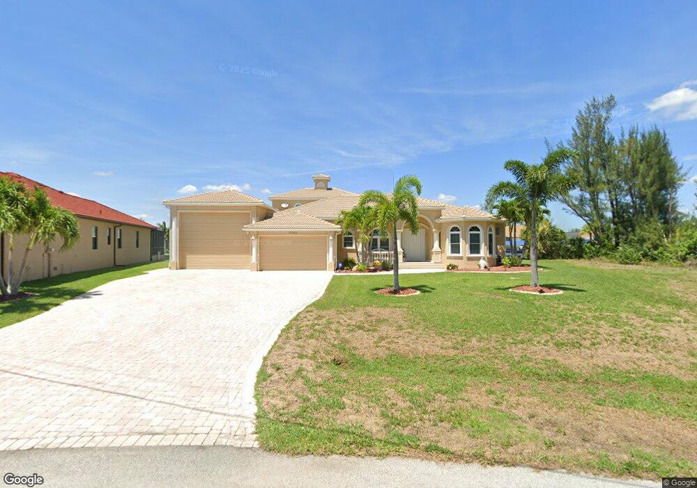
10544 Poughkeepsie Cir Port Charlotte, FL 33981
Gulf Cove NeighborhoodEstimated Value: $1,346,000 - $1,462,000
4
Beds
4
Baths
3,558
Sq Ft
$392/Sq Ft
Est. Value
About This Home
This home is located at 10544 Poughkeepsie Cir, Port Charlotte, FL 33981 and is currently estimated at $1,393,919, approximately $391 per square foot. 10544 Poughkeepsie Cir is a home located in Charlotte County with nearby schools including Myakka River Elementary School, L.A. Ainger Middle School, and Lemon Bay High School.
Ownership History
Date
Name
Owned For
Owner Type
Purchase Details
Closed on
Nov 20, 2014
Sold by
Suntrust Bank
Bought by
Morchesky Kenneth D and Morchesky Linda R
Current Estimated Value
Purchase Details
Closed on
Aug 22, 2014
Sold by
Peerce Patricia S
Bought by
Suntrust Bank
Purchase Details
Closed on
Dec 22, 2006
Sold by
Peerce Jon A and Peerce Patricia S
Bought by
Peerce Jon A and Peerce Patricia S
Purchase Details
Closed on
Apr 28, 2004
Sold by
National Recreational Properties Of Port
Bought by
Peerce Jon A and Peerce Patricia S
Home Financials for this Owner
Home Financials are based on the most recent Mortgage that was taken out on this home.
Original Mortgage
$152,000
Interest Rate
5.36%
Mortgage Type
Purchase Money Mortgage
Create a Home Valuation Report for This Property
The Home Valuation Report is an in-depth analysis detailing your home's value as well as a comparison with similar homes in the area
Home Values in the Area
Average Home Value in this Area
Purchase History
| Date | Buyer | Sale Price | Title Company |
|---|---|---|---|
| Morchesky Kenneth D | $415,000 | Consuegra Title Llc | |
| Suntrust Bank | $311,900 | None Available | |
| Peerce Jon A | -- | Attorney | |
| Peerce Jon A | $190,000 | -- |
Source: Public Records
Mortgage History
| Date | Status | Borrower | Loan Amount |
|---|---|---|---|
| Previous Owner | Peerce Jon A | $152,000 |
Source: Public Records
Tax History Compared to Growth
Tax History
| Year | Tax Paid | Tax Assessment Tax Assessment Total Assessment is a certain percentage of the fair market value that is determined by local assessors to be the total taxable value of land and additions on the property. | Land | Improvement |
|---|---|---|---|---|
| 2023 | $8,158 | $520,616 | $0 | $0 |
| 2022 | $7,906 | $509,195 | $0 | $0 |
| 2021 | $7,946 | $494,364 | $0 | $0 |
| 2020 | $7,828 | $487,538 | $0 | $0 |
| 2019 | $7,671 | $476,577 | $0 | $0 |
| 2018 | $7,150 | $467,691 | $0 | $0 |
| 2017 | $6,382 | $414,626 | $95,200 | $319,426 |
| 2016 | $9,346 | $523,871 | $0 | $0 |
| 2015 | $8,846 | $489,438 | $0 | $0 |
| 2014 | $7,967 | $411,034 | $0 | $0 |
Source: Public Records
Map
Nearby Homes
- 10522 Riverside Rd
- 10611 Riverside Rd
- 10454 Atenia St
- 10580 Poughkeepsie Cir
- 10413 Atenia St
- 10610 Riverside Rd
- 10443 Riverside Rd
- 10486 Poughkeepsie Cir
- 10628 Poughkeepsie Cir
- 10453 Poughkeepsie Cir
- 10471 Poughkeepsie Cir
- 10495 Atenia St
- 10426 Riverside Rd
- 10462 Poughkeepsie Cir
- 15017 Lyneburg Ave
- 10365 Atenia St
- 10378 Sunday Dr
- 10476 Atenia St
- 15040 Lyneburg Ave
- 15101 Brainbridge Cir
- 10534 Poughkeepsie Cir
- 10554 Poughkeepsie Cir
- 1369 Sarasota Rd
- 1338 Sarasota Rd
- 10562 Poughkeepsie Cir
- 10555 Poughkeepsie Cir
- 10526 Poughkeepsie Cir
- 10578 Riverside Rd
- 10430 Street
- 10563 Poughkeepsie Cir
- 10586 Riverside Rd
- 10570 Poughkeepsie Cir
- 10562 Riverside Rd
- 10554 Riverside Rd
- 10422 Atenia St
- 10510 Poughkeepsie Cir
- 10555 Riverside Rd
- 10595 Riverside Rd
- 10587 Riverside Rd