Estimated Value: $84,119 - $132,000
1
Bed
2
Baths
1,197
Sq Ft
$89/Sq Ft
Est. Value
About This Home
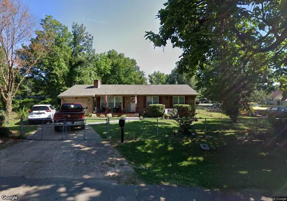
This home is located at 1055 Forrest Ave W, Wynne, AR 72396 and is currently estimated at $107,030, approximately $89 per square foot. 1055 Forrest Ave W is a home located in Cross County with nearby schools including Wynne Primary School, Wynne Intermediate School, and Wynne Junior High School.
Ownership History
Date
Name
Owned For
Owner Type
Purchase Details
Closed on
Nov 14, 2014
Sold by
Stone Financing Llc
Bought by
Mcdaniel Arlene and Mcdaniel Ricky
Current Estimated Value
Home Financials for this Owner
Home Financials are based on the most recent Mortgage that was taken out on this home.
Original Mortgage
$65,272
Outstanding Balance
$50,221
Interest Rate
4.12%
Mortgage Type
FHA
Estimated Equity
$56,809
Purchase Details
Closed on
Oct 7, 2005
Sold by
Cunningham Walter L and Cunningham Van
Bought by
Mcgill Terrance Lee
Home Financials for this Owner
Home Financials are based on the most recent Mortgage that was taken out on this home.
Original Mortgage
$64,490
Interest Rate
5.69%
Create a Home Valuation Report for This Property
The Home Valuation Report is an in-depth analysis detailing your home's value as well as a comparison with similar homes in the area
Home Values in the Area
Average Home Value in this Area
Purchase History
| Date | Buyer | Sale Price | Title Company |
|---|---|---|---|
| Mcdaniel Arlene | $66,500 | Janus Title | |
| Mcgill Terrance Lee | $65,000 | None Available |
Source: Public Records
Mortgage History
| Date | Status | Borrower | Loan Amount |
|---|---|---|---|
| Open | Mcdaniel Arlene | $65,272 | |
| Previous Owner | Mcgill Terrance Lee | $64,490 |
Source: Public Records
Tax History Compared to Growth
Tax History
| Year | Tax Paid | Tax Assessment Tax Assessment Total Assessment is a certain percentage of the fair market value that is determined by local assessors to be the total taxable value of land and additions on the property. | Land | Improvement |
|---|---|---|---|---|
| 2024 | $41 | $10,100 | $1,110 | $8,990 |
| 2023 | $41 | $10,100 | $1,110 | $8,990 |
| 2022 | $91 | $10,100 | $1,110 | $8,990 |
| 2021 | $91 | $10,100 | $1,110 | $8,990 |
| 2020 | $69 | $10,100 | $1,110 | $8,990 |
| 2019 | $48 | $8,550 | $1,060 | $7,490 |
| 2018 | $73 | $8,550 | $1,060 | $7,490 |
| 2017 | $73 | $8,550 | $1,060 | $7,490 |
| 2016 | $73 | $8,550 | $1,060 | $7,490 |
| 2015 | $73 | $8,550 | $1,060 | $7,490 |
| 2014 | $146 | $10,020 | $960 | $9,060 |
Source: Public Records
Map
Nearby Homes
- 813 Childress Dr
- 0 Brittney Cir Unit 43670
- 0 Brittney Cir Unit 25030957
- 1002 Brittney Cir
- 0 Cr 760
- 624 C St
- 136 Matthew Addition Cove
- 714 Church St N
- 513 Forrest Ave E
- 1910 Union Ave W
- 514 Poplar Ave E
- 704 Front St S
- 607 Bruce St N
- 411 N Bruce St
- 810 Forrest Ave E
- 908 Block St S
- 903 Levesque Ave E
- 106 Eldridge Ct
- 919 Hamilton Ave E
- 1783 Hart
- 1057 Forrest Ave W
- 1058 Poplar Ave W
- 1053 Forrest Ave W
- 1056 Forrest Ave W
- 641 N St
- 631 N St
- 1063 Forrest Ave W
- 1048 Poplar Ave W
- 1054 Forrest Ave W
- 1017 Forrest Ave W
- 1064 Forrest Ave W
- 1050 Forrest Ave W
- 1065 Forrest Ave W
- 1036 Poplar Ave W
- 1032 Poplar Ave W
- 101 M St
- 1040 Poplar Ave W
- 618 O St
- 1062 Forrest Ave W
- 1062 Forrest Ave W