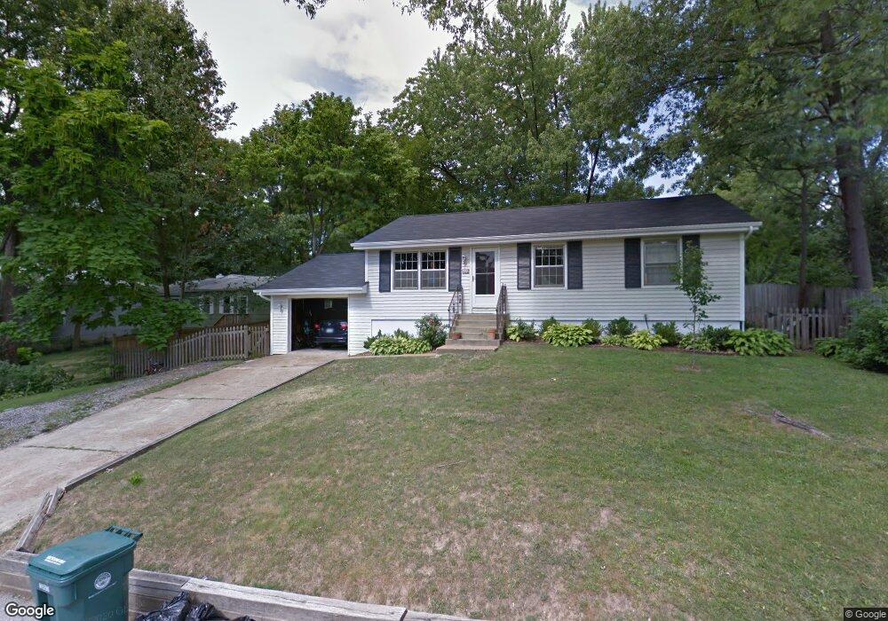
1055 Kenmore Dr Saint Louis, MO 63122
Estimated Value: $338,569 - $374,000
3
Beds
1
Bath
1,040
Sq Ft
$344/Sq Ft
Est. Value
About This Home
This home is located at 1055 Kenmore Dr, Saint Louis, MO 63122 and is currently estimated at $358,142, approximately $344 per square foot. 1055 Kenmore Dr is a home located in St. Louis County with nearby schools including North Glendale Elementary School, Nipher Middle School, and Kirkwood Senior High School.
Ownership History
Date
Name
Owned For
Owner Type
Purchase Details
Closed on
Apr 18, 2005
Sold by
Starkey Wayne E
Bought by
Buettner Jeffrey and Buettner Tatyana
Current Estimated Value
Home Financials for this Owner
Home Financials are based on the most recent Mortgage that was taken out on this home.
Original Mortgage
$136,000
Outstanding Balance
$70,682
Interest Rate
5.89%
Mortgage Type
Fannie Mae Freddie Mac
Estimated Equity
$287,460
Create a Home Valuation Report for This Property
The Home Valuation Report is an in-depth analysis detailing your home's value as well as a comparison with similar homes in the area
Home Values in the Area
Average Home Value in this Area
Purchase History
| Date | Buyer | Sale Price | Title Company |
|---|---|---|---|
| Buettner Jeffrey | -- | -- |
Source: Public Records
Mortgage History
| Date | Status | Borrower | Loan Amount |
|---|---|---|---|
| Open | Buettner Jeffrey | $136,000 |
Source: Public Records
Tax History Compared to Growth
Tax History
| Year | Tax Paid | Tax Assessment Tax Assessment Total Assessment is a certain percentage of the fair market value that is determined by local assessors to be the total taxable value of land and additions on the property. | Land | Improvement |
|---|---|---|---|---|
| 2025 | $3,157 | $52,910 | $46,890 | $6,020 |
| 2024 | $3,157 | $50,100 | $39,060 | $11,040 |
| 2023 | $3,107 | $50,100 | $39,060 | $11,040 |
| 2022 | $2,907 | $43,710 | $37,340 | $6,370 |
| 2021 | $2,870 | $43,710 | $37,340 | $6,370 |
| 2020 | $3,126 | $45,830 | $37,340 | $8,490 |
| 2019 | $3,127 | $45,830 | $37,340 | $8,490 |
| 2018 | $2,931 | $37,930 | $28,140 | $9,790 |
| 2017 | $2,928 | $37,930 | $28,140 | $9,790 |
| 2016 | $2,141 | $27,860 | $21,890 | $5,970 |
| 2015 | $2,139 | $27,860 | $21,890 | $5,970 |
| 2014 | $1,921 | $24,440 | $11,060 | $13,380 |
Source: Public Records
Map
Nearby Homes
- 1 Dickson Ct
- 1306 Glendale Gardens Dr Unit B
- 1306 Glendale Gardens Dr Unit C
- 641 Brookhaven Ct
- 830 Victoria Place
- 1095 N Sappington Rd
- 551 Brookhaven Ct
- 826 Chelsea Ave
- 858 Chelsea Ave
- 754 Brownell Ave
- 1025 Glenmoor Ln
- 1509 Andrew Dr
- 1030 Sylvan Place
- 931 Brownell Ave
- 65 Ridge Line Dr
- 987 Dwyer Ave
- 438 N Sappington Rd Unit B
- 436 N Sappington Rd Unit C
- 946 Dwyer Ave
- 832 Fuhrmann Terrace
- 649 Lewiston Dr
- 647 Lewiston Dr
- 1220 Kenmore Dr
- 651 Lewiston Dr
- 645 Lewiston Dr
- 1051 Kenmore Dr
- 1125 Glenway Dr
- 640 Tarrymore Ln
- 1230 Kenmore Dr
- 1105 Glenway Dr
- 634 Tarrymore Ln
- 648 Lewiston Dr
- 648UC Lewiston Dr
- 655 Lewiston Dr
- 1292 Kenmore Dr
- 647 Warrenton Dr
- 1093 Glenway Dr
- 641 Warrenton Dr
- 1141 Glenway Dr
- 1 Tbb-W Njl