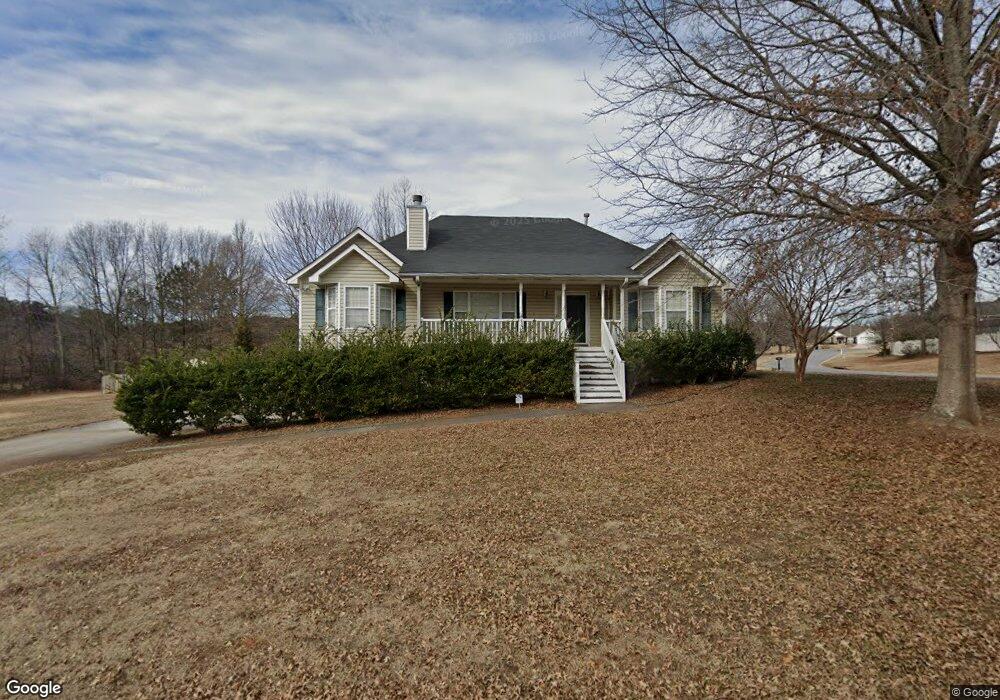
1055 Mustang Dr Dallas, GA 30157
Estimated Value: $322,924 - $371,000
3
Beds
2
Baths
1,788
Sq Ft
$193/Sq Ft
Est. Value
About This Home
This home is located at 1055 Mustang Dr, Dallas, GA 30157 and is currently estimated at $344,481, approximately $192 per square foot. 1055 Mustang Dr is a home located in Paulding County with nearby schools including Allgood Elementary School, Herschel Jones Middle School, and Paulding County High School.
Ownership History
Date
Name
Owned For
Owner Type
Purchase Details
Closed on
Feb 20, 2015
Sold by
Taylor Nancy A
Current Estimated Value
Purchase Details
Closed on
Dec 7, 2012
Sold by
Taylor Tommy R
Bought by
Taylor Nancy A
Home Financials for this Owner
Home Financials are based on the most recent Mortgage that was taken out on this home.
Original Mortgage
$98,561
Interest Rate
3.37%
Mortgage Type
FHA
Create a Home Valuation Report for This Property
The Home Valuation Report is an in-depth analysis detailing your home's value as well as a comparison with similar homes in the area
Home Values in the Area
Average Home Value in this Area
Purchase History
| Date | Buyer | Sale Price | Title Company |
|---|---|---|---|
| -- | -- | -- | |
| Taylor Nancy A | -- | -- |
Source: Public Records
Mortgage History
| Date | Status | Borrower | Loan Amount |
|---|---|---|---|
| Previous Owner | Taylor Nancy A | $98,561 |
Source: Public Records
Tax History Compared to Growth
Tax History
| Year | Tax Paid | Tax Assessment Tax Assessment Total Assessment is a certain percentage of the fair market value that is determined by local assessors to be the total taxable value of land and additions on the property. | Land | Improvement |
|---|---|---|---|---|
| 2024 | $2,891 | $119,468 | $12,000 | $107,468 |
| 2023 | $3,126 | $122,448 | $12,000 | $110,448 |
| 2022 | $2,656 | $103,748 | $12,000 | $91,748 |
| 2021 | $2,438 | $85,748 | $8,000 | $77,748 |
| 2020 | $2,410 | $82,992 | $8,000 | $74,992 |
| 2019 | $2,102 | $71,624 | $8,000 | $63,624 |
| 2018 | $1,959 | $66,880 | $8,000 | $58,880 |
| 2017 | $1,899 | $64,040 | $8,000 | $56,040 |
| 2016 | $1,833 | $62,480 | $8,000 | $54,480 |
| 2015 | $1,542 | $51,960 | $8,000 | $43,960 |
| 2014 | $1,600 | $52,560 | $8,000 | $44,560 |
| 2013 | -- | $41,040 | $8,000 | $33,040 |
Source: Public Records
Map
Nearby Homes
- 39 Bent Creek Ct
- 180 Kensington Path
- 138 Ponderosa Dr
- 158 Laurel Farms Ln
- 1496 Villa Rica Hwy
- 1997 Villa Rica Hwy
- 72 Victorian Cir
- 297 Jewel Cole Rd
- Amelia Plan at Laurel Farms - Designer Collection
- Morgan Plan at Laurel Farms - Designer Collection
- Maxwell Plan at Laurel Farms - Designer Collection
- Edenton Plan at Laurel Farms - Designer Collection
- Wilmington Plan at Laurel Farms - Designer Collection
- Camden Plan at Laurel Farms - Designer Collection
- 127 Laurel Farms Ln
- 128 Laurel Farms Ln
- 148 Laurel Farms Ln
- 125 Laurel Farms Ln
- 138 Laurel Farms Ln
- 115 Laurel Farms Ln
- 0 Bent Creek Place Unit 7403879
- 0 Bent Creek Place Unit 7628457
- 25 Bent Creek Place
- 1019 Mustang Dr
- 1068 Mustang Dr
- 1097 Mustang Dr
- 1020 Mustang Dr
- 1110 Mustang Dr
- 31 Bent Creek Trail
- 60 Bent Creek Place
- 35 Bent Creek Trail
- 28 Bent Creek Trail
- 1121 Mustang Dr
- 65 Bent Creek Place
- 0 Bent Creek Ct Unit 8820182
- 0 Bent Creek Ct Unit 8690431
- 0 Bent Creek Ct
- 89 Bent Creek Place
- 89 Bent Creek Place
- 80 Bent Creek Place