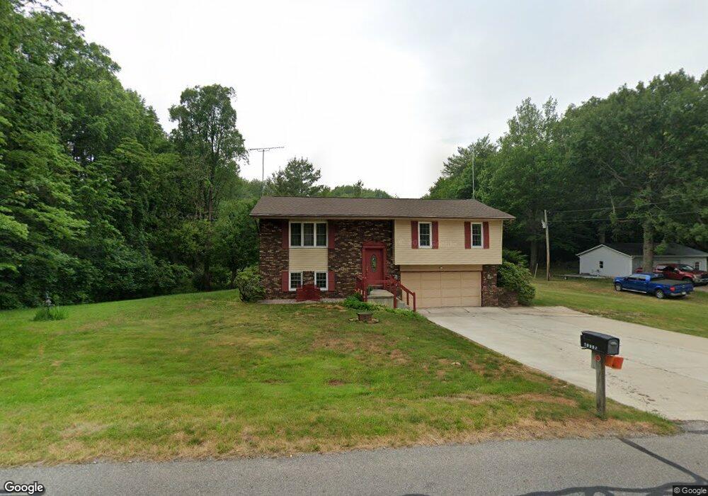
10557 Muckshaw Rd Plymouth, IN 46563
Estimated Value: $222,000 - $263,076
3
Beds
2
Baths
1,672
Sq Ft
$145/Sq Ft
Est. Value
About This Home
This home is located at 10557 Muckshaw Rd, Plymouth, IN 46563 and is currently estimated at $242,769, approximately $145 per square foot. 10557 Muckshaw Rd is a home located in Marshall County with nearby schools including Plymouth High School, St. Michael School, and St. Michael's Catholic School.
Ownership History
Date
Name
Owned For
Owner Type
Purchase Details
Closed on
Feb 21, 2006
Sold by
Schultz Mark A and Schultz Shannon L
Bought by
Babcock David D and Babcock Rosalie A
Current Estimated Value
Home Financials for this Owner
Home Financials are based on the most recent Mortgage that was taken out on this home.
Original Mortgage
$80,000
Outstanding Balance
$45,383
Interest Rate
6.33%
Mortgage Type
New Conventional
Estimated Equity
$197,386
Purchase Details
Closed on
May 24, 1999
Sold by
Berger Wade A and Berger Lisa A
Bought by
Schultz Mark A and Schultz Shannon L
Create a Home Valuation Report for This Property
The Home Valuation Report is an in-depth analysis detailing your home's value as well as a comparison with similar homes in the area
Home Values in the Area
Average Home Value in this Area
Purchase History
| Date | Buyer | Sale Price | Title Company |
|---|---|---|---|
| Babcock David D | -- | None Available | |
| Schultz Mark A | $93,000 | -- |
Source: Public Records
Mortgage History
| Date | Status | Borrower | Loan Amount |
|---|---|---|---|
| Open | Babcock David D | $80,000 |
Source: Public Records
Tax History Compared to Growth
Tax History
| Year | Tax Paid | Tax Assessment Tax Assessment Total Assessment is a certain percentage of the fair market value that is determined by local assessors to be the total taxable value of land and additions on the property. | Land | Improvement |
|---|---|---|---|---|
| 2024 | $1,087 | $167,300 | $39,400 | $127,900 |
| 2022 | $1,087 | $154,600 | $36,400 | $118,200 |
| 2021 | $914 | $129,800 | $30,400 | $99,400 |
| 2020 | $916 | $125,100 | $29,200 | $95,900 |
| 2019 | $868 | $122,700 | $28,600 | $94,100 |
| 2018 | $823 | $119,300 | $27,800 | $91,500 |
| 2017 | $706 | $116,000 | $27,200 | $88,800 |
| 2016 | $657 | $112,700 | $26,500 | $86,200 |
| 2014 | $528 | $104,100 | $25,700 | $78,400 |
Source: Public Records
Map
Nearby Homes
- 10535 Muckshaw Rd
- 10599 Muckshaw Rd
- 10600 Muckshaw Rd
- 13060 Nutmeg Ridge Dr
- 10649 Muckshaw Rd
- 13080 Nutmeg Ridge Dr
- 10640 Muckshaw Rd
- 13110 Nutmeg Ridge Dr
- 13051 Nutmeg Ridge Dr
- 13154 Nutmeg Trail
- 13128 Nutmeg Trail
- 13001 Nutmeg Ridge Dr
- 13073 Nutmeg Ridge Dr
- 13101 Nutmeg Ridge Dr
- 13164 Nutmeg Trail
- 10650 Muckshaw Rd
- 10660 Muckshaw Rd
- 13200 Nutmeg Trail
- 13129 Nutmeg Ridge Dr
- 13122 Nutmeg Ridge Dr