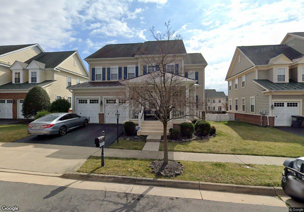
10563 Andrew Humphreys Ct Bristow, VA 20136
Estimated Value: $790,000 - $835,000
4
Beds
4
Baths
3,298
Sq Ft
$245/Sq Ft
Est. Value
About This Home
This home is located at 10563 Andrew Humphreys Ct, Bristow, VA 20136 and is currently estimated at $809,369, approximately $245 per square foot. 10563 Andrew Humphreys Ct is a home located in Prince William County with nearby schools including T. Clay Wood Elementary School, E.H. Marsteller Middle School, and Brentsville District High School.
Ownership History
Date
Name
Owned For
Owner Type
Purchase Details
Closed on
Dec 28, 2005
Sold by
Centex Homes
Bought by
Gubesch Michael
Current Estimated Value
Home Financials for this Owner
Home Financials are based on the most recent Mortgage that was taken out on this home.
Original Mortgage
$464,800
Outstanding Balance
$263,105
Interest Rate
6.39%
Mortgage Type
New Conventional
Estimated Equity
$546,264
Create a Home Valuation Report for This Property
The Home Valuation Report is an in-depth analysis detailing your home's value as well as a comparison with similar homes in the area
Home Values in the Area
Average Home Value in this Area
Purchase History
| Date | Buyer | Sale Price | Title Company |
|---|---|---|---|
| Gubesch Michael | $581,035 | -- |
Source: Public Records
Mortgage History
| Date | Status | Borrower | Loan Amount |
|---|---|---|---|
| Open | Gubesch Michael | $464,800 |
Source: Public Records
Tax History Compared to Growth
Tax History
| Year | Tax Paid | Tax Assessment Tax Assessment Total Assessment is a certain percentage of the fair market value that is determined by local assessors to be the total taxable value of land and additions on the property. | Land | Improvement |
|---|---|---|---|---|
| 2025 | $6,763 | $744,300 | $208,600 | $535,700 |
| 2024 | $6,763 | $680,000 | $198,700 | $481,300 |
| 2023 | $6,659 | $640,000 | $164,400 | $475,600 |
| 2022 | $6,623 | $598,000 | $164,400 | $433,600 |
| 2021 | $6,393 | $524,700 | $142,400 | $382,300 |
| 2020 | $7,609 | $490,900 | $142,400 | $348,500 |
| 2019 | $7,198 | $464,400 | $142,400 | $322,000 |
| 2018 | $5,744 | $475,700 | $142,400 | $333,300 |
| 2017 | $5,844 | $475,200 | $142,400 | $332,800 |
| 2016 | $5,677 | $465,900 | $135,900 | $330,000 |
| 2015 | $5,311 | $458,000 | $128,700 | $329,300 |
| 2014 | $5,311 | $426,000 | $119,000 | $307,000 |
Source: Public Records
Map
Nearby Homes
- 10554 Andrew Humphreys Ct
- 10423 Rifle Rd
- 12021 Spring Beauty Rd
- 10512 Blazing Star Loop
- 12054 Nokesville Rd
- 12151 Hayfield Ct
- 12204 Hoop Ct
- 12048 Elliots Oak Place
- 12127 & 12131 Vint Hill Rd
- 9579 Scales Place
- 9656 Bedder Stone Place
- 10941 Samuel Trexler Dr
- Hampton II Plan at Parkgate Estates
- 10028 Boreland Ct
- 12417 Nokesville Rd
- 12750 Brewland Way
- 10045 Pentland Hills Way
- 9218 Dawkins Crest Cir
- 9475 Sarah Mill Terrace
- 9381 Crestview Ridge Dr
- 10567 Andrew Humphreys Ct
- 10559 Andrew Humphreys Ct
- 10571 Andrew Humphreys Ct
- 10530 Poagues Battery Dr
- 10536 Poagues Battery Dr
- 10524 Poagues Battery Dr
- 11871 Frank Haskell Ct
- 11877 Frank Haskell Ct
- 10562 Andrew Humphreys Ct
- 11865 Frank Haskell Ct
- 10540 Poagues Battery Dr
- 10558 Andrew Humphreys Ct
- 10568 Andrew Humphreys Ct
- 10544 Poagues Battery Dr
- 10520 Poagues Battery Dr
- 10579 Andrew Humphreys Ct
- 10550 Andrew Humphreys Ct
- 10594 Andrew Humphreys Ct
- 11895 Frank Haskell Ct
- 10529 Poagues Battery Dr