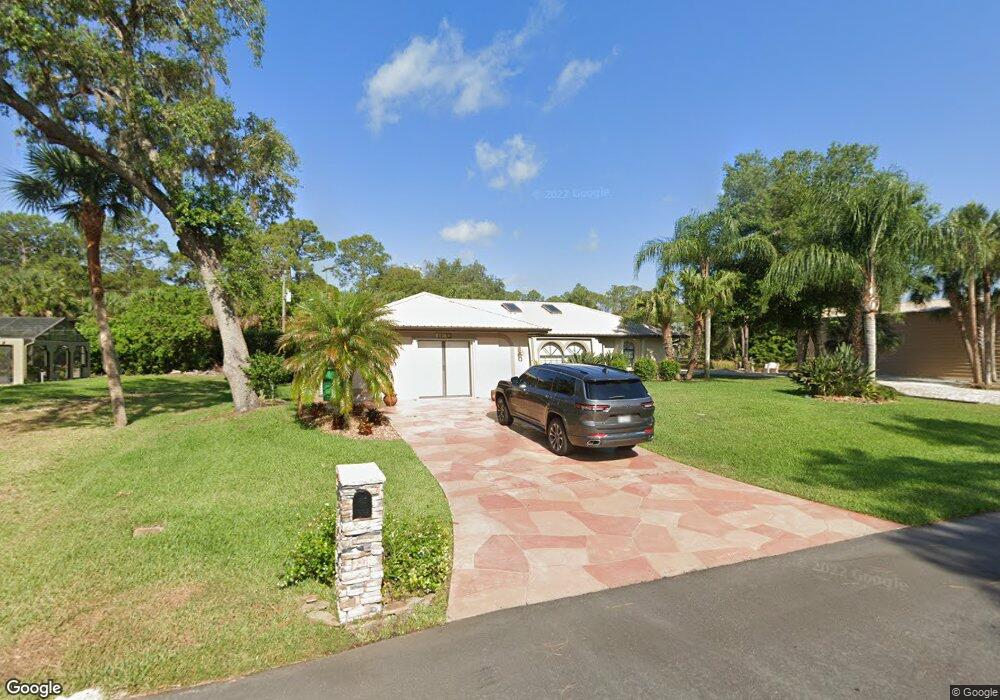
1057 Cabot St Port Charlotte, FL 33953
Northwest Port Charlotte NeighborhoodEstimated Value: $342,700 - $417,000
3
Beds
2
Baths
1,992
Sq Ft
$185/Sq Ft
Est. Value
About This Home
This home is located at 1057 Cabot St, Port Charlotte, FL 33953 and is currently estimated at $368,675, approximately $185 per square foot. 1057 Cabot St is a home located in Charlotte County with nearby schools including Liberty Elementary School, Murdock Middle School, and Port Charlotte High School.
Ownership History
Date
Name
Owned For
Owner Type
Purchase Details
Closed on
Jul 23, 2012
Sold by
Boyce Keith
Bought by
Ham Donald R and Ham Ann P
Current Estimated Value
Purchase Details
Closed on
Sep 22, 2011
Sold by
Ham Donald R and Ham Ann P
Bought by
Ham Donald R and Ham Ann P
Purchase Details
Closed on
May 12, 1998
Sold by
Atlantic Gulf Com Corp
Bought by
Ham Donald R and Ham Ann P
Home Financials for this Owner
Home Financials are based on the most recent Mortgage that was taken out on this home.
Original Mortgage
$97,150
Interest Rate
7.04%
Create a Home Valuation Report for This Property
The Home Valuation Report is an in-depth analysis detailing your home's value as well as a comparison with similar homes in the area
Home Values in the Area
Average Home Value in this Area
Purchase History
| Date | Buyer | Sale Price | Title Company |
|---|---|---|---|
| Ham Donald R | $8,000 | Siesta Title & Escrow Llc | |
| Ham Donald R | -- | Attorney | |
| Ham Donald R | $17,700 | -- |
Source: Public Records
Mortgage History
| Date | Status | Borrower | Loan Amount |
|---|---|---|---|
| Previous Owner | Ham Donald R | $97,150 |
Source: Public Records
Tax History Compared to Growth
Tax History
| Year | Tax Paid | Tax Assessment Tax Assessment Total Assessment is a certain percentage of the fair market value that is determined by local assessors to be the total taxable value of land and additions on the property. | Land | Improvement |
|---|---|---|---|---|
| 2023 | $2,345 | $113,709 | $0 | $0 |
| 2022 | $2,228 | $110,397 | $0 | $0 |
| 2021 | $1,930 | $97,445 | $0 | $0 |
| 2020 | $1,874 | $96,100 | $0 | $0 |
| 2019 | $1,785 | $93,939 | $0 | $0 |
| 2018 | $1,653 | $92,187 | $0 | $0 |
| 2017 | $1,629 | $90,291 | $0 | $0 |
| 2016 | $1,610 | $88,434 | $0 | $0 |
| 2015 | $1,592 | $87,819 | $0 | $0 |
| 2014 | $1,372 | $87,122 | $0 | $0 |
Source: Public Records
Map
Nearby Homes
- 1072 Cabot St
- 1105 Cabot St
- 15074 Faulkner Ave
- 1112 Cornelius Blvd
- 15090 Rebecca Ave
- 1166 Chagrin Ln
- 1234 Lotus St
- 15248 Malcolm Ave
- 15106 Gulistan Ave
- 15098 Gulistan Ave
- 15152 Gulistan Ave
- 15247 Faulkner Ave
- 15105 Faulkner Ave
- 14435 Grenoble Ave
- 15074 Carousel Ln
- 430 Cornelius Blvd
- 1355 Cornelius Blvd
- 2090 Cornelius Blvd
- 1097 Cornelius Blvd
- 1056 Cornelius Blvd
- 1065 Cabot St
- 1048 Cornelius Blvd
- 1056 Cabot St
- 1081 Cabot St
- Gulistan Ave
- 1032 Cornelius Blvd
- 15040 Faulkner Ave
- 15058 Malcolm Ave
- 1065 Cornelius Blvd
- 1088 Cornelius Blvd
- 1073 Cornelius Blvd
- 15057 Gulistan Ave
- 1097 Cabot St
- 1017 Cabot St
- 1096 Cornelius Blvd
- 15065 Malcolm Ave
- 1009 Cabot St
- 1025 & 1033 Cornelius Blvd
- 1064 Shearer St
- 1040 Shearer St