Estimated Value: $430,000 - $735,000
--
Bed
--
Bath
1
Sq Ft
$550,860/Sq Ft
Est. Value
About This Home
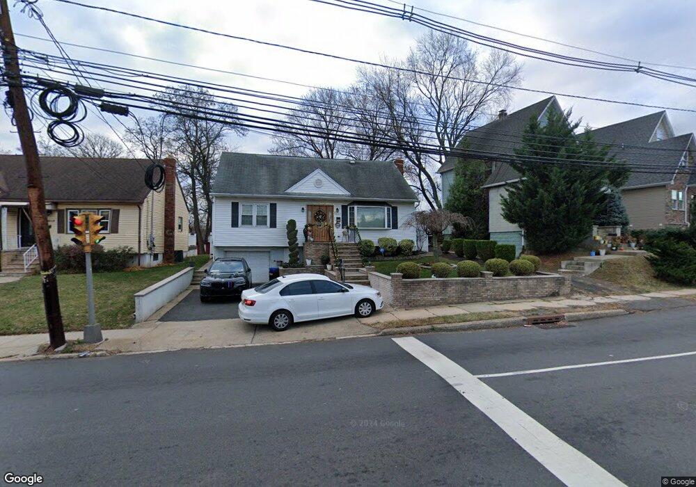
This home is located at 1057 Salem Rd, Union, NJ 07083 and is currently estimated at $550,860, approximately $550,860 per square foot. 1057 Salem Rd is a home located in Union County with nearby schools including Livingston Elementary School and Union High School.
Ownership History
Date
Name
Owned For
Owner Type
Purchase Details
Closed on
Apr 22, 2016
Sold by
Miguel A Martinez
Bought by
Pereira Angelo and Pereira Rosa
Current Estimated Value
Home Financials for this Owner
Home Financials are based on the most recent Mortgage that was taken out on this home.
Original Mortgage
$267,400
Outstanding Balance
$211,803
Interest Rate
3.59%
Estimated Equity
$339,057
Purchase Details
Closed on
Mar 10, 2000
Sold by
Martinez Anna M
Bought by
Martinez Miguel A
Purchase Details
Closed on
Jul 17, 1995
Sold by
Gousman Evelyn
Bought by
Martinez Miguel A and Martinez Anna M
Create a Home Valuation Report for This Property
The Home Valuation Report is an in-depth analysis detailing your home's value as well as a comparison with similar homes in the area
Home Values in the Area
Average Home Value in this Area
Purchase History
| Date | Buyer | Sale Price | Title Company |
|---|---|---|---|
| Pereira Angelo | -- | -- | |
| Martinez Miguel A | -- | -- | |
| Martinez Miguel A | $153,000 | -- |
Source: Public Records
Mortgage History
| Date | Status | Borrower | Loan Amount |
|---|---|---|---|
| Open | Pereira Angelo | $267,400 | |
| Closed | Pereira Angelo | -- |
Source: Public Records
Tax History Compared to Growth
Tax History
| Year | Tax Paid | Tax Assessment Tax Assessment Total Assessment is a certain percentage of the fair market value that is determined by local assessors to be the total taxable value of land and additions on the property. | Land | Improvement |
|---|---|---|---|---|
| 2025 | $10,259 | $45,900 | $20,700 | $25,200 |
| 2024 | $9,946 | $45,900 | $20,700 | $25,200 |
| 2023 | $9,946 | $45,900 | $20,700 | $25,200 |
| 2022 | $9,600 | $45,900 | $20,700 | $25,200 |
| 2021 | $9,368 | $45,900 | $20,700 | $25,200 |
| 2020 | $9,181 | $45,900 | $20,700 | $25,200 |
| 2019 | $9,057 | $45,900 | $20,700 | $25,200 |
| 2018 | $8,903 | $45,900 | $20,700 | $25,200 |
| 2017 | $8,771 | $45,900 | $20,700 | $25,200 |
| 2016 | $8,185 | $43,900 | $20,700 | $23,200 |
| 2015 | $8,049 | $43,900 | $20,700 | $23,200 |
| 2014 | $7,869 | $43,900 | $20,700 | $23,200 |
Source: Public Records
Map
Nearby Homes
- 169 Valley View Rd
- 969 Arnet Ave
- 1322 Marcella Dr
- 314 Fitzpatrick St
- 1370 Beverly Rd
- 292 Crann St
- 875 Salem Rd
- 1393 Cornell Place
- 1048 Chester St
- 507 Locust Ave
- 790 Green Ln Unit A1
- 365 Broadwell Ave
- 257 Herbert Ave
- 795 Colonial Arms Rd
- 1084 Woodland Ave
- 553 Harvard Ave
- 383 Conant St
- 393 Harvard Ave
- 1040 Cranbrook Rd
- 328 Minute Arms Rd