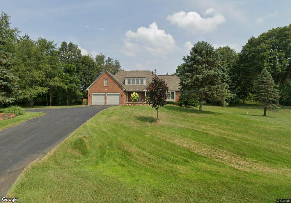
10570 Liberty Way Davisburg, MI 48350
Rose Township NeighborhoodEstimated Value: $439,808 - $496,000
3
Beds
3
Baths
2,008
Sq Ft
$231/Sq Ft
Est. Value
About This Home
This home is located at 10570 Liberty Way, Davisburg, MI 48350 and is currently estimated at $463,452, approximately $230 per square foot. 10570 Liberty Way is a home located in Oakland County with nearby schools including Holly High School.
Ownership History
Date
Name
Owned For
Owner Type
Purchase Details
Closed on
Jan 31, 2023
Sold by
Troxell Susan K and Troxell Frank B
Bought by
Troxell Susan K
Current Estimated Value
Purchase Details
Closed on
Jan 2, 2014
Sold by
Troxell Frank B
Bought by
Troxell Susan K and Troxell Frank B
Purchase Details
Closed on
Oct 15, 1997
Sold by
Building Company
Bought by
Troxell Frank B
Home Financials for this Owner
Home Financials are based on the most recent Mortgage that was taken out on this home.
Original Mortgage
$70,000
Interest Rate
7.65%
Create a Home Valuation Report for This Property
The Home Valuation Report is an in-depth analysis detailing your home's value as well as a comparison with similar homes in the area
Home Values in the Area
Average Home Value in this Area
Purchase History
| Date | Buyer | Sale Price | Title Company |
|---|---|---|---|
| Troxell Susan K | -- | Land Title | |
| Troxell Susan K | -- | None Available | |
| Troxell Frank B | $38,900 | -- |
Source: Public Records
Mortgage History
| Date | Status | Borrower | Loan Amount |
|---|---|---|---|
| Previous Owner | Troxell Frank B | $70,000 |
Source: Public Records
Tax History Compared to Growth
Tax History
| Year | Tax Paid | Tax Assessment Tax Assessment Total Assessment is a certain percentage of the fair market value that is determined by local assessors to be the total taxable value of land and additions on the property. | Land | Improvement |
|---|---|---|---|---|
| 2024 | $2,657 | $193,740 | $0 | $0 |
| 2023 | $2,534 | $186,290 | $0 | $0 |
| 2022 | $3,066 | $164,830 | $0 | $0 |
| 2021 | $2,733 | $151,050 | $0 | $0 |
| 2020 | $2,319 | $148,110 | $0 | $0 |
| 2019 | $2,651 | $145,730 | $0 | $0 |
| 2018 | $2,595 | $133,180 | $0 | $0 |
| 2017 | $2,548 | $133,180 | $0 | $0 |
| 2016 | $2,533 | $127,370 | $0 | $0 |
| 2015 | -- | $116,770 | $0 | $0 |
| 2014 | -- | $97,920 | $0 | $0 |
| 2011 | -- | $88,890 | $0 | $0 |
Source: Public Records
Map
Nearby Homes
- 3015 Patriot Square
- 10461 Eagle Rd
- 207 Linda Ln
- 102 Forest Way
- 113 Forest Way
- 300 Samantha Way
- 303 Samantha Way
- 298 Samantha Way
- 304 Samantha Way
- 312 Samantha Way
- 112 Forest Way
- 309 Samantha Way
- 123 Forest Way
- 10705 Deer Ridge Trail
- 00 Deer Ridge Trail
- 13705 Davisburg Rd
- 00 Tamryn Blvd
- 7812 Fountain Hills Ln
- 13175 Hummingbird Ridge
- 12800 Fountain Square
- 3000 Davisburg Rd
- 10600 Liberty Way Unit 6
- 10575 Liberty Way
- 3080 Davisburg Rd
- 10535 Liberty Way Unit 3
- 10605 Liberty Way
- 10540 Liberty Way
- 3160 Davisburg Rd
- 10564 Eagle Rd
- 10520 Liberty Way
- 3250 Davisburg Rd
- 10590 Eagle Rd
- 10570 Eagle Rd
- 10500 Liberty Way
- 3300 Davisburg Rd
- 2975 Patriot Square
- 10470 Liberty Way
- 10435 Liberty Way
- 10457 Eagle Rd
- 10601 Eagle Rd