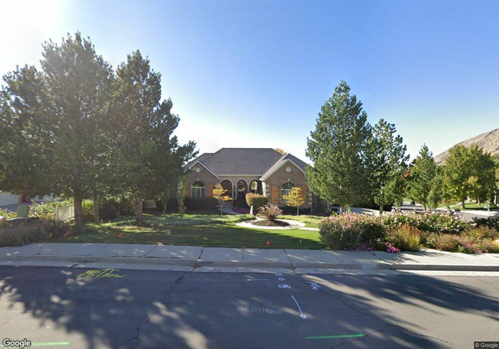
1058 S 2500 E Springville, UT 84663
East Hobble Creek NeighborhoodEstimated Value: $944,000 - $984,153
5
Beds
4
Baths
5,224
Sq Ft
$185/Sq Ft
Est. Value
About This Home
This home is located at 1058 S 2500 E, Springville, UT 84663 and is currently estimated at $966,051, approximately $184 per square foot. 1058 S 2500 E is a home located in Utah County with nearby schools including Brookside School, Springville High School, and Springville Junior High School.
Ownership History
Date
Name
Owned For
Owner Type
Purchase Details
Closed on
Feb 21, 2017
Sold by
Mckelvey William J and Mc Kelvey Amber
Bought by
Mckelvey Holdings Llc
Current Estimated Value
Purchase Details
Closed on
Nov 5, 2015
Sold by
Mckelvey William
Bought by
Mckelvey Amber
Purchase Details
Closed on
Mar 14, 2014
Sold by
Mckelvey Amber
Bought by
Mckelvey William J and Mc Kelvey Amber
Purchase Details
Closed on
Jun 16, 2004
Sold by
Mckelvey William
Bought by
Mckelvey Amber
Purchase Details
Closed on
May 26, 1998
Sold by
Weiser Russel and Weiser Nancy
Bought by
Mckelvey William and Mckelvey Amber
Home Financials for this Owner
Home Financials are based on the most recent Mortgage that was taken out on this home.
Original Mortgage
$340,500
Outstanding Balance
$66,705
Interest Rate
7.13%
Estimated Equity
$899,346
Create a Home Valuation Report for This Property
The Home Valuation Report is an in-depth analysis detailing your home's value as well as a comparison with similar homes in the area
Home Values in the Area
Average Home Value in this Area
Purchase History
| Date | Buyer | Sale Price | Title Company |
|---|---|---|---|
| Mckelvey Holdings Llc | -- | None Available | |
| Mckelvey Amber | -- | None Available | |
| Mckelvey William J | -- | None Available | |
| Mckelvey Amber | -- | -- | |
| Mckelvey William | -- | -- |
Source: Public Records
Mortgage History
| Date | Status | Borrower | Loan Amount |
|---|---|---|---|
| Open | Mckelvey William | $340,500 |
Source: Public Records
Tax History
| Year | Tax Paid | Tax Assessment Tax Assessment Total Assessment is a certain percentage of the fair market value that is determined by local assessors to be the total taxable value of land and additions on the property. | Land | Improvement |
|---|---|---|---|---|
| 2025 | $4,523 | $461,835 | -- | -- |
| 2024 | $4,523 | $463,375 | $0 | $0 |
| 2023 | $4,419 | $453,200 | $0 | $0 |
| 2022 | $4,154 | $418,330 | $0 | $0 |
| 2021 | $3,732 | $585,100 | $201,000 | $384,100 |
| 2020 | $3,539 | $537,800 | $174,800 | $363,000 |
| 2019 | $3,364 | $520,500 | $159,500 | $361,000 |
| 2018 | $3,435 | $507,100 | $146,100 | $361,000 |
| 2017 | $3,350 | $262,625 | $0 | $0 |
| 2016 | $3,042 | $233,860 | $0 | $0 |
| 2015 | $2,816 | $221,320 | $0 | $0 |
| 2014 | $2,551 | $199,210 | $0 | $0 |
Source: Public Records
Map
Nearby Homes
- 2541 Stonebury Loop Rd
- 1052 Cove Dr
- 829 S 2200 E
- 2881 Thirty Oaks Dr Unit 6
- 2881 Thirty Oaks Dr
- 1092 Valley Sage Dr
- 1096 Valley Sage Dr
- 715 E 1700 N
- 59 E 775 S Unit 21
- 52 E 775 S Unit 19
- 1839 River Bottom Rd
- 1567 N 600 E Unit 26
- 1447 N 1350 St E Unit 5
- 1577 N 1350 St E Unit 1
- 1477 N 1350 St E Unit 4
- 1547 N 1350 St E Unit 2
- 1511 N 1350 St E Unit 3
- 1548 N 1350 St E Unit 11
- 1578 N 1350 St E Unit 12
- 24 Quiet Meadow Ln
- 2524 Stonebury Loop Rd
- 1060 S 2500 E
- 949 S 2400 E
- 944 S 2400 E
- 971 S 2500 E
- 971 S 2500 E Unit 1
- 1080 S 2500 E
- 1055 S 2500 E
- 1071 S 2350 E Unit 210
- 955 S 2500 E
- 948 S 2400 E
- 1075 S 2500 E
- 955 S 2400 E
- 955 S 2400 E
- 959 S 2400 E
- 2445 Canyon Rd
- 1051 S 2350 E Unit 209
- 965 S 2400 E
- 1140 S 2500 E
- 951 S 2500 E
Your Personal Tour Guide
Ask me questions while you tour the home.