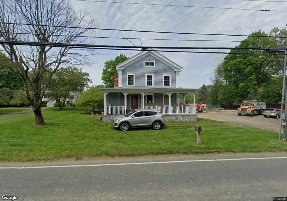
1059 Daniels Farm Rd Trumbull, CT 06611
Daniel Farm District NeighborhoodEstimated Value: $647,000 - $785,086
2
Beds
1
Bath
1,485
Sq Ft
$497/Sq Ft
Est. Value
About This Home
This home is located at 1059 Daniels Farm Rd, Trumbull, CT 06611 and is currently estimated at $738,272, approximately $497 per square foot. 1059 Daniels Farm Rd is a home located in Fairfield County with nearby schools including Daniels Farm School, Hillcrest Middle School, and Trumbull High School.
Ownership History
Date
Name
Owned For
Owner Type
Purchase Details
Closed on
Sep 30, 2010
Sold by
Suita Joseph
Bought by
Rodrigues Antonio R and Rodrigues Irene
Current Estimated Value
Home Financials for this Owner
Home Financials are based on the most recent Mortgage that was taken out on this home.
Original Mortgage
$240,287
Outstanding Balance
$158,725
Interest Rate
4.37%
Mortgage Type
FHA
Estimated Equity
$579,547
Create a Home Valuation Report for This Property
The Home Valuation Report is an in-depth analysis detailing your home's value as well as a comparison with similar homes in the area
Home Values in the Area
Average Home Value in this Area
Purchase History
| Date | Buyer | Sale Price | Title Company |
|---|---|---|---|
| Rodrigues Antonio R | $160,000 | -- |
Source: Public Records
Mortgage History
| Date | Status | Borrower | Loan Amount |
|---|---|---|---|
| Open | Rodrigues Antonio R | $240,287 |
Source: Public Records
Tax History Compared to Growth
Tax History
| Year | Tax Paid | Tax Assessment Tax Assessment Total Assessment is a certain percentage of the fair market value that is determined by local assessors to be the total taxable value of land and additions on the property. | Land | Improvement |
|---|---|---|---|---|
| 2025 | $13,038 | $353,150 | $148,120 | $205,030 |
| 2024 | $12,584 | $350,420 | $148,120 | $202,300 |
| 2023 | $8,881 | $251,370 | $148,120 | $103,250 |
| 2022 | $8,739 | $251,370 | $148,120 | $103,250 |
| 2021 | $8,918 | $244,020 | $135,170 | $108,850 |
| 2020 | $4,057 | $244,020 | $135,170 | $108,850 |
| 2018 | $8,532 | $244,020 | $135,170 | $108,850 |
| 2017 | $8,360 | $244,020 | $135,170 | $108,850 |
| 2016 | $8,192 | $244,020 | $135,170 | $108,850 |
| 2015 | $6,313 | $185,900 | $135,200 | $50,700 |
| 2014 | $6,178 | $185,900 | $135,200 | $50,700 |
Source: Public Records
Map
Nearby Homes
- 1209 Daniels Farm Rd
- 121 Lewis Rd
- 119 Lewis Rd
- 93 Putting Green Rd N
- 184 Hurd Rd
- 118 Greenbrier Rd
- 36 Moose Hill Rd
- 43 Moose Hill Rd
- 3 Pam Bar Dr
- 184 Putting Green Rd
- 6 Brookview Dr
- 18 Skating Pond Rd
- 31 Parlor Rock Rd
- 101 Royals Ct
- 57 Gray Rock Rd
- 230 Fitch Pass
- 14 Oakland Dr
- 14 Gisella Rd
- 6680 Main St
- 0 Main St
- 1057 Daniels Farm Rd
- 1035 Daniels Farm Rd
- 1075 Daniels Farm Rd
- 1069 Daniels Farm Rd
- 1054 Daniels Farm Rd
- 1089 Daniels Farm Rd
- 1040 Daniels Farm Rd
- 14 Lewis Rd
- 1021 Daniels Farm Rd
- 19 Highwood Place
- 22 Lewis Rd
- 5 Wildfire Ln
- 1097 Daniels Farm Rd
- 15 Highwood Place
- 15 Hillsboro Rd
- 11 Highwood Place
- 23 Highwood Place
- 9 Wildfire Ln
- 30 Lewis Rd
- 1003 Daniels Farm Rd