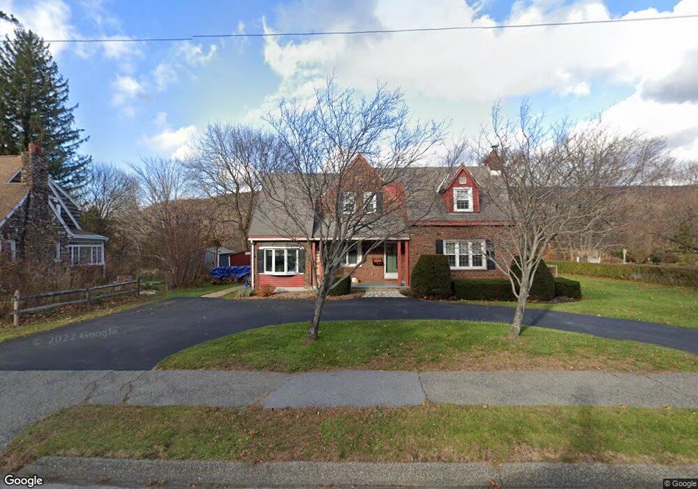
1059 State Rd North Adams, MA 01247
Estimated Value: $278,000 - $311,974
3
Beds
2
Baths
1,753
Sq Ft
$168/Sq Ft
Est. Value
About This Home
This home is located at 1059 State Rd, North Adams, MA 01247 and is currently estimated at $294,244, approximately $167 per square foot. 1059 State Rd is a home located in Berkshire County with nearby schools including Greylock Elementary School, Drury High School, and Pine Cobble School.
Ownership History
Date
Name
Owned For
Owner Type
Purchase Details
Closed on
Aug 16, 2018
Sold by
Stpierre Roger E and St Pierre Donna A
Bought by
Hanna Elizabeth A and Stpierre Matthew R
Current Estimated Value
Purchase Details
Closed on
Oct 11, 1985
Bought by
Stpierre Roger E and Stpierre Donna A
Create a Home Valuation Report for This Property
The Home Valuation Report is an in-depth analysis detailing your home's value as well as a comparison with similar homes in the area
Home Values in the Area
Average Home Value in this Area
Purchase History
| Date | Buyer | Sale Price | Title Company |
|---|---|---|---|
| Hanna Elizabeth A | -- | -- | |
| Stpierre Roger E | -- | -- |
Source: Public Records
Mortgage History
| Date | Status | Borrower | Loan Amount |
|---|---|---|---|
| Previous Owner | Stpierre Roger E | $20,000 |
Source: Public Records
Tax History Compared to Growth
Tax History
| Year | Tax Paid | Tax Assessment Tax Assessment Total Assessment is a certain percentage of the fair market value that is determined by local assessors to be the total taxable value of land and additions on the property. | Land | Improvement |
|---|---|---|---|---|
| 2025 | $5,148 | $308,100 | $33,700 | $274,400 |
| 2024 | $4,832 | $281,900 | $30,800 | $251,100 |
| 2023 | $4,642 | $262,700 | $30,800 | $231,900 |
| 2022 | $4,154 | $224,200 | $30,800 | $193,400 |
| 2021 | $3,862 | $207,500 | $28,600 | $178,900 |
| 2020 | $3,564 | $191,400 | $28,400 | $163,000 |
| 2019 | $3,384 | $177,100 | $28,400 | $148,700 |
| 2018 | $3,126 | $175,800 | $29,900 | $145,900 |
| 2017 | $3,076 | $174,100 | $29,600 | $144,500 |
| 2016 | $2,979 | $171,300 | $29,600 | $141,700 |
| 2015 | $2,877 | $172,400 | $30,600 | $141,800 |
Source: Public Records
Map
Nearby Homes
- 20 Kateley Ln
- 131 Luce Rd
- 217 Main St
- 17 Phelps Ave
- 1 State Rd
- 46 Cobble View Rd
- 14 Orchard Ln
- 15 Orchard Ln
- 0 Holly Ln
- 39 Foucher Ave
- 108 Berkshire Dr
- 505 Barbour St
- 5 Windflower Way
- 189 Stratton Rd Unit E2
- 189 Stratton Rd Unit E3
- 227 Protection Ave
- 16 Windflower Way
- 25 Taft St
- 2 River Run
- 2 River Run Rd