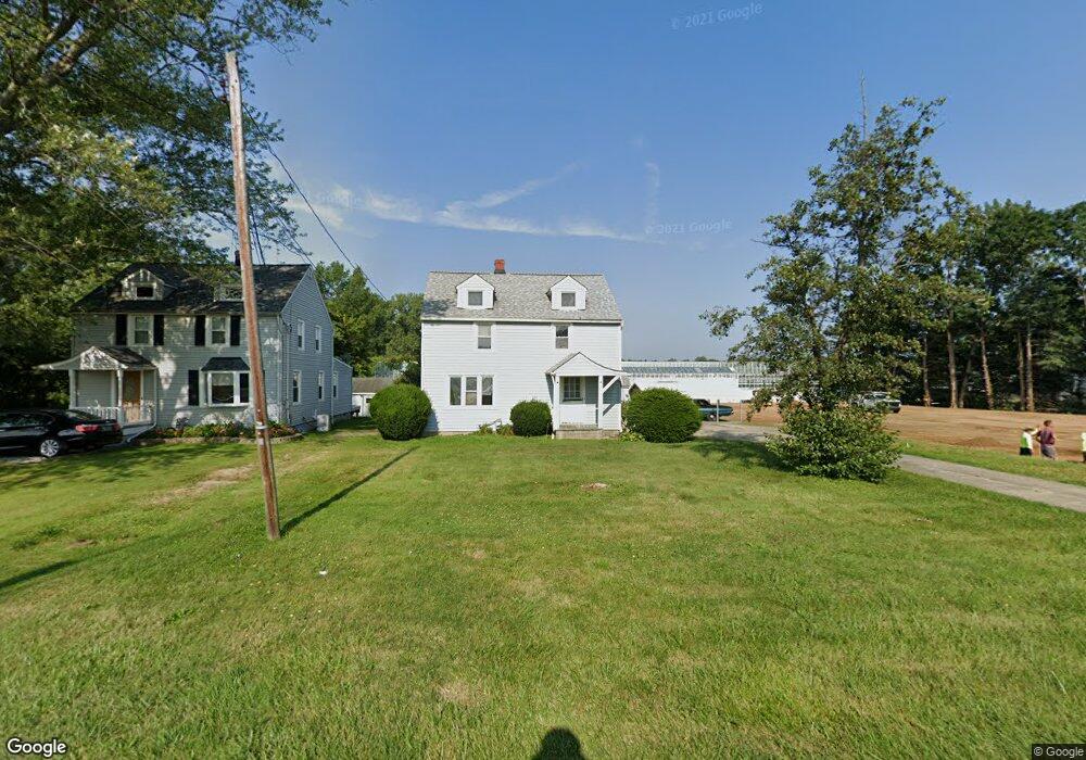
10598 E River Rd Columbia Station, OH 44028
Estimated Value: $216,070 - $336,000
3
Beds
2
Baths
1,200
Sq Ft
$210/Sq Ft
Est. Value
About This Home
This home is located at 10598 E River Rd, Columbia Station, OH 44028 and is currently estimated at $251,518, approximately $209 per square foot. 10598 E River Rd is a home located in Lorain County with nearby schools including Copopa Elementary School, Columbia Middle School, and Columbia High School.
Ownership History
Date
Name
Owned For
Owner Type
Purchase Details
Closed on
Aug 6, 2004
Sold by
Molina Mildred and Kalinoski Karen E
Bought by
Nichols Samuel E
Current Estimated Value
Home Financials for this Owner
Home Financials are based on the most recent Mortgage that was taken out on this home.
Original Mortgage
$113,050
Outstanding Balance
$59,010
Interest Rate
6.8%
Mortgage Type
Purchase Money Mortgage
Estimated Equity
$192,508
Purchase Details
Closed on
May 3, 1996
Sold by
Green Circle Growers Inc
Bought by
Molina Jack A and Molina Mildred
Create a Home Valuation Report for This Property
The Home Valuation Report is an in-depth analysis detailing your home's value as well as a comparison with similar homes in the area
Home Values in the Area
Average Home Value in this Area
Purchase History
| Date | Buyer | Sale Price | Title Company |
|---|---|---|---|
| Nichols Samuel E | $119,000 | Midland Title Security Inc | |
| Molina Jack A | $2,200 | -- |
Source: Public Records
Mortgage History
| Date | Status | Borrower | Loan Amount |
|---|---|---|---|
| Open | Nichols Samuel E | $113,050 |
Source: Public Records
Tax History Compared to Growth
Tax History
| Year | Tax Paid | Tax Assessment Tax Assessment Total Assessment is a certain percentage of the fair market value that is determined by local assessors to be the total taxable value of land and additions on the property. | Land | Improvement |
|---|---|---|---|---|
| 2024 | $2,498 | $55,657 | $17,248 | $38,409 |
| 2023 | $2,240 | $43,519 | $17,112 | $26,408 |
| 2022 | $2,188 | $43,519 | $17,112 | $26,408 |
| 2021 | $2,209 | $43,519 | $17,112 | $26,408 |
| 2020 | $2,134 | $37,740 | $14,840 | $22,900 |
| 2019 | $2,122 | $37,740 | $14,840 | $22,900 |
| 2018 | $2,152 | $37,740 | $14,840 | $22,900 |
| 2017 | $2,164 | $35,450 | $14,790 | $20,660 |
| 2016 | $2,179 | $35,450 | $14,790 | $20,660 |
| 2015 | $2,179 | $35,450 | $14,790 | $20,660 |
| 2014 | $2,186 | $35,450 | $14,790 | $20,660 |
| 2013 | $2,194 | $35,450 | $14,790 | $20,660 |
Source: Public Records
Map
Nearby Homes
- Lehigh Plan at Ashford Cove
- Anderson Plan at Ashford Cove
- Ballenger Plan at Ashford Cove
- Columbia Plan at Ashford Cove
- Hudson Plan at Ashford Cove
- 0 E River Rd Unit 5120285
- Belleville Plan at The Estates of Columbia Ridge
- Ash Lawn Plan at The Estates of Columbia Ridge
- Brennan Plan at The Estates of Columbia Ridge
- Lyndhurst Plan at The Estates of Columbia Ridge
- Alden Plan at The Estates of Columbia Ridge
- Vanderburgh Plan at The Estates of Columbia Ridge
- Buchanan Plan at The Estates of Columbia Ridge
- 31525 Blooming Ln
- 9749 E River Rd N
- 24835 W Northwood Dr
- 24628 Sprague Rd
- 12584 Caribou Ct
- 24848 River Glen Dr
- 26179 Raintree Blvd Unit D8
- 10604 E River Rd
- 10668 E River Rd
- 10556 East River Rd
- 10506 East River Rd
- 10496 East River Rd
- 1046 Ashford Ct
- 1046 Ashford Ct
- 1012 Ashford Ct Unit 12567059296185469056
- 1012 Ashford Ct Unit 741385461945046346
- 1012 Ashford Ct Unit 11675758979163202223
- 1012 Ashford Ct Unit 16155993735473650946
- 1012 Ashford Ct Unit 16422360460814205118
- 1030 Ashford Ct
- 10476 East River Rd
- 10515 E River Rd
- 10706 East River Rd
- 10475 East River Rd
- 10756 E River Rd
- 10732 E River Rd
- 10786 East River Rd