Estimated Value: $102,000 - $157,000
3
Beds
1
Bath
960
Sq Ft
$138/Sq Ft
Est. Value
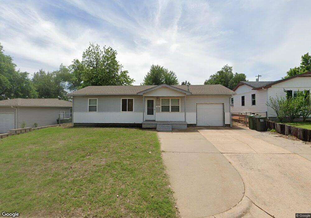
About This Home
This home is located at 106 Asbill Ave, Yukon, OK 73099 and is currently estimated at $132,259, approximately $137 per square foot. 106 Asbill Ave is a home located in Canadian County with nearby schools including Myers Elementary School, Independence Elementary School, and Yukon Middle School.
Ownership History
Date
Name
Owned For
Owner Type
Purchase Details
Closed on
Oct 28, 2011
Sold by
Daffern Michelle Deann
Bought by
Jackson William
Current Estimated Value
Home Financials for this Owner
Home Financials are based on the most recent Mortgage that was taken out on this home.
Original Mortgage
$59,063
Outstanding Balance
$40,720
Interest Rate
4.25%
Mortgage Type
FHA
Estimated Equity
$91,539
Purchase Details
Closed on
Jul 23, 1997
Sold by
Smith Robin J
Purchase Details
Closed on
Dec 27, 1989
Purchase Details
Closed on
Aug 31, 1989
Purchase Details
Closed on
May 15, 1989
Create a Home Valuation Report for This Property
The Home Valuation Report is an in-depth analysis detailing your home's value as well as a comparison with similar homes in the area
Home Values in the Area
Average Home Value in this Area
Purchase History
| Date | Buyer | Sale Price | Title Company |
|---|---|---|---|
| Jackson William | $59,000 | None Available | |
| -- | $41,000 | -- | |
| -- | -- | -- | |
| -- | $25,000 | -- | |
| -- | -- | -- |
Source: Public Records
Mortgage History
| Date | Status | Borrower | Loan Amount |
|---|---|---|---|
| Open | Jackson William | $59,063 |
Source: Public Records
Tax History Compared to Growth
Tax History
| Year | Tax Paid | Tax Assessment Tax Assessment Total Assessment is a certain percentage of the fair market value that is determined by local assessors to be the total taxable value of land and additions on the property. | Land | Improvement |
|---|---|---|---|---|
| 2024 | $793 | $8,316 | $1,161 | $7,155 |
| 2023 | $793 | $8,316 | $1,232 | $7,084 |
| 2022 | $796 | $8,316 | $1,802 | $6,514 |
| 2021 | $799 | $8,316 | $1,820 | $6,496 |
| 2020 | $789 | $8,316 | $1,980 | $6,336 |
| 2019 | $775 | $8,167 | $1,980 | $6,187 |
| 2018 | $752 | $7,929 | $1,980 | $5,949 |
| 2017 | $792 | $8,300 | $1,980 | $6,320 |
| 2016 | $766 | $8,074 | $1,980 | $6,094 |
| 2015 | -- | $7,823 | $1,980 | $5,843 |
| 2014 | -- | $7,762 | $1,837 | $5,925 |
Source: Public Records
Map
Nearby Homes
- 117 Asbill Ave
- 0 Landon Ln
- 1005 S 3rd St
- 11200 SW 32nd St
- 301 Fay Ave
- 114 Larry Ave
- 14512 Rochefort Ln
- 14524 Giverny Ln
- 14500 Giverny Ln
- 201 Vine St
- 11501 NW 97th St
- 1805 Janeen St
- 904 Glenwood Dr
- 501 Queensboro Place
- 1308 Holly Ave
- 810 Ridgeway Dr
- 508 Kingston Dr
- 1421 Spring Creek Dr
- 414 Yukon Ave
- 10401 NW 33rd St
- 104 Asbill Ave
- 108 Asbill Ave
- 110 Asbill Ave
- 107 Asbill Ave
- 102 Asbill Ave
- 105 Asbill Ave
- 109 Asbill Ave
- 111 Asbill Ave
- 105 Belisle Ave
- 107 Belisle Ave
- 109 Belisle Ave
- 1200 S Cornwell Dr
- 103 Asbill Ave
- 103 Belisle Ave
- 101 Asbill Ave
- 113 Asbill Ave
- 114 Asbill Ave
- 101 Belisle Ave
- 110 Belisle Ave
- 115 Asbill Ave