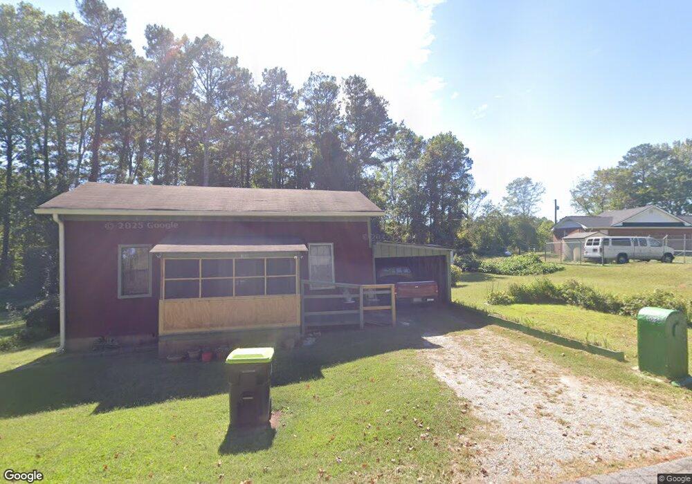
106 Hayes Glass Dr Bremen, GA 30110
Estimated Value: $146,000 - $209,000
2
Beds
1
Bath
956
Sq Ft
$183/Sq Ft
Est. Value
About This Home
This home is located at 106 Hayes Glass Dr, Bremen, GA 30110 and is currently estimated at $174,667, approximately $182 per square foot. 106 Hayes Glass Dr is a home located in Haralson County with nearby schools including Jones Elementary School, Bremen 4th & 5th Grade Academy, and Bremen Middle School.
Ownership History
Date
Name
Owned For
Owner Type
Purchase Details
Closed on
Nov 2, 2007
Sold by
Carter Beatrice Elder
Bought by
Elder Tony Wade
Current Estimated Value
Purchase Details
Closed on
Oct 2, 2007
Sold by
Favors Linda A
Bought by
Favors Eric Jerome
Purchase Details
Closed on
Sep 12, 1992
Sold by
Carter Beatrice Elder
Bought by
Carter Beatrice Elder Favors Linda
Purchase Details
Closed on
Sep 10, 1988
Sold by
Elder Wade Estate By Carter Beatrice Eld
Bought by
Carter Beatrice Elder
Create a Home Valuation Report for This Property
The Home Valuation Report is an in-depth analysis detailing your home's value as well as a comparison with similar homes in the area
Home Values in the Area
Average Home Value in this Area
Purchase History
| Date | Buyer | Sale Price | Title Company |
|---|---|---|---|
| Elder Tony Wade | -- | -- | |
| Favors Eric Jerome | -- | -- | |
| Carter Beatrice Elder Favors Linda | -- | -- | |
| Carter Beatrice Elder | -- | -- |
Source: Public Records
Tax History Compared to Growth
Tax History
| Year | Tax Paid | Tax Assessment Tax Assessment Total Assessment is a certain percentage of the fair market value that is determined by local assessors to be the total taxable value of land and additions on the property. | Land | Improvement |
|---|---|---|---|---|
| 2024 | $287 | $10,235 | $6,420 | $3,815 |
| 2023 | $279 | $9,267 | $5,400 | $3,867 |
| 2022 | $82 | $8,539 | $5,400 | $3,139 |
| 2021 | $85 | $8,410 | $5,400 | $3,010 |
| 2020 | $87 | $8,591 | $5,400 | $3,191 |
| 2019 | $86 | $8,217 | $5,400 | $2,817 |
| 2018 | $87 | $8,217 | $5,400 | $2,817 |
| 2017 | $92 | $7,784 | $5,400 | $2,384 |
| 2016 | $128 | $10,322 | $5,400 | $4,922 |
| 2015 | $127 | $10,222 | $5,400 | $4,822 |
| 2014 | $172 | $12,848 | $8,000 | $4,848 |
Source: Public Records
Map
Nearby Homes
- 6315 Highway 78
- 735 Tallapoosa St W
- 522 Atlantic Ave
- 0 Sewell Rd Unit 10624236
- 0 Sewell Rd Unit 7665305
- 273 Sewell Rd
- 225 Edwards St
- 0 Mt Zion St Unit 7399245
- 330 Kensington Cir
- 311 Kensington Cir
- 707 Mill Stone Way
- 319 Stonebridge Blvd
- 321 Stonebridge Blvd
- 111 Bryan St W
- 101 Bush Creek Way
- 201 Stonebridge Blvd
- 223 Gordon St
- 0 Stonebridge Blvd Unit 143588
- 627 Tallapoosa St W
- 641 Tallapoosa St W
- 649 Tallapoosa St W
- 0 Tallapoosa St Unit 7186909
- 0 Tallapoosa St Unit 7034784
- 0 Tallapoosa St
- W Tallapoosa St
- 718 Atlanta St
- 769 Atlantic Ave
- 706 Atlanta St
- 704 Atlantic Ave
- 704 Atlantic Ave
- 700 Atlantic Ave
- 613 Tallapoosa St W
- 634 Atlantic Ave
- 621 Atlantic Ave
- 630 Atlantic Ave
- 152 Robinson St
- 150 Robinson St
- 150 Hayes Glass Dr