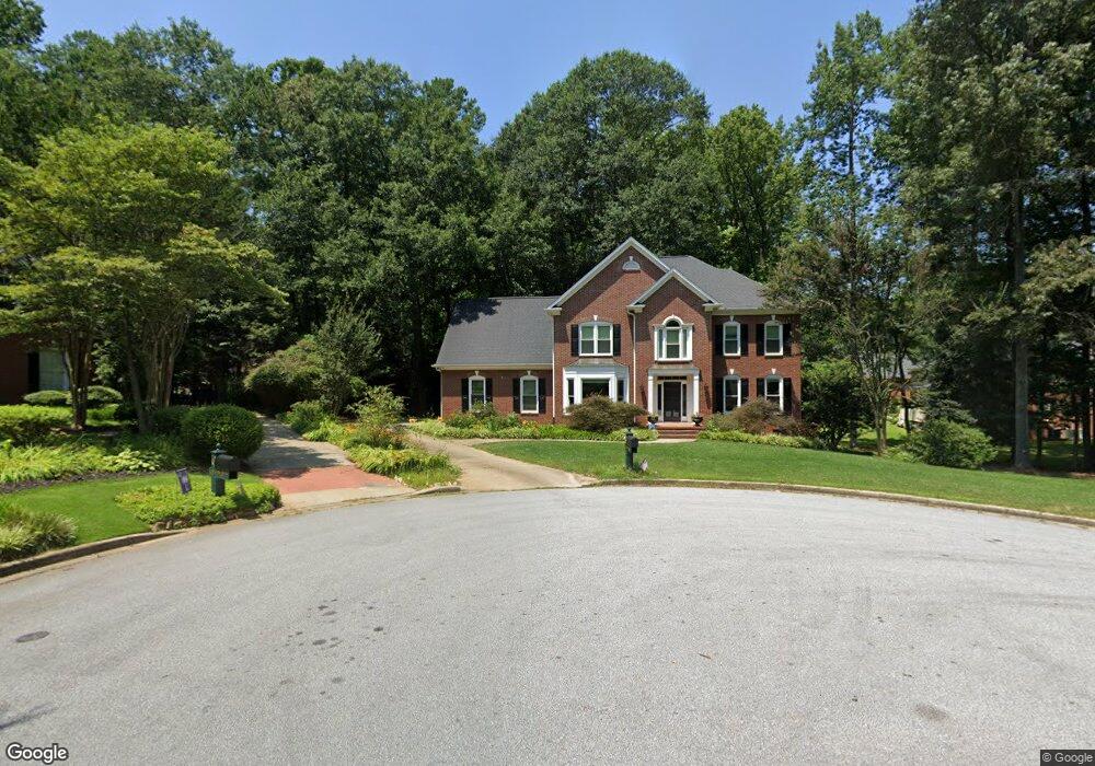
106 Maple Brook Ct Simpsonville, SC 29681
Estimated Value: $562,482 - $766,000
4
Beds
3
Baths
3,208
Sq Ft
$208/Sq Ft
Est. Value
About This Home
This home is located at 106 Maple Brook Ct, Simpsonville, SC 29681 and is currently estimated at $666,621, approximately $207 per square foot. 106 Maple Brook Ct is a home located in Greenville County with nearby schools including Monarch Elementary, Mauldin Middle School, and Mauldin High School.
Ownership History
Date
Name
Owned For
Owner Type
Purchase Details
Closed on
May 22, 2009
Sold by
White Gordon R and White Lisa C
Bought by
Kirk Brian E and Kirk Christy P
Current Estimated Value
Home Financials for this Owner
Home Financials are based on the most recent Mortgage that was taken out on this home.
Original Mortgage
$275,200
Outstanding Balance
$171,238
Interest Rate
4.89%
Mortgage Type
New Conventional
Estimated Equity
$495,383
Create a Home Valuation Report for This Property
The Home Valuation Report is an in-depth analysis detailing your home's value as well as a comparison with similar homes in the area
Home Values in the Area
Average Home Value in this Area
Purchase History
| Date | Buyer | Sale Price | Title Company |
|---|---|---|---|
| Kirk Brian E | $344,000 | -- |
Source: Public Records
Mortgage History
| Date | Status | Borrower | Loan Amount |
|---|---|---|---|
| Open | Kirk Brian E | $275,200 |
Source: Public Records
Tax History
| Year | Tax Paid | Tax Assessment Tax Assessment Total Assessment is a certain percentage of the fair market value that is determined by local assessors to be the total taxable value of land and additions on the property. | Land | Improvement |
|---|---|---|---|---|
| 2025 | $2,700 | $19,060 | $3,980 | $15,080 |
| 2024 | $2,700 | $16,570 | $2,800 | $13,770 |
| 2023 | $2,597 | $16,570 | $2,800 | $13,770 |
| 2022 | $2,531 | $16,570 | $2,800 | $13,770 |
| 2021 | $2,533 | $16,570 | $2,800 | $13,770 |
| 2020 | $2,647 | $16,570 | $2,800 | $13,770 |
| 2019 | $2,299 | $14,350 | $2,300 | $12,050 |
| 2018 | $2,359 | $14,350 | $2,300 | $12,050 |
| 2017 | $2,362 | $14,350 | $2,300 | $12,050 |
| 2016 | $2,283 | $358,760 | $57,500 | $301,260 |
| 2015 | $2,288 | $358,760 | $57,500 | $301,260 |
| 2014 | $1,902 | $311,970 | $50,000 | $261,970 |
Source: Public Records
Map
Nearby Homes
- 4 Flagstone Ct
- 103 Silver Fox Trail
- 207 Poplar Ridge Rd
- 104 Laurel Oak Trail
- 218 Lovelace Ct
- 135 Adams Creek Place
- 325 Stillwater Ct
- 104 Morell Dr
- 1 Morell Dr
- 5 Kinglet Ct
- 5 Bathurst Ln
- 1202 Plantation Dr
- 2 Ivory Arch Ct
- 313 Squires Creek Rd
- 301 Cypress Hill Ct Unit (Cypresshill)
- 114 Gilderview Dr
- 712 Spring Lake Loop
- 102 Spring Lake Loop
- 17 Gilder Point Ct
- 3 Cedarhill Ct
- 104 Maple Brook Ct
- 108 Maple Brook Ct
- 102 Maple Brook Ct
- 107 Maple Brook Ct
- 5 Black Pine Ct
- 111 Maple Brook Ct
- 109 Maple Brook Ct
- 110 Maple Brook Ct
- 111 Hidden Oak Terrace
- 105 Maple Brook Ct
- 103 Maple Brook Ct
- 1 Black Pine Ct
- 101 Maple Brook Ct
- 7 Black Pine Ct
- 1 Castlegate Ct
- 2 Castlegate Ct
- 110 Hidden Oak Terrace
- 109 Hidden Oak Terrace
- 6 Flagstone Ct
- 1116 River Walk Dr
Your Personal Tour Guide
Ask me questions while you tour the home.